Karim Ullah High School

Last updated

Karim Ullah High School is a secondary school at Daganbhuiyan Upazila in Feni District in Bangladesh. [1] The school is situated in the Matubhuiyan Union of the upazila. The school operates with Class VI to Class X. The school is a MPO-Index based institution. There is a large pond along with a beautiful ancient mosque in front of the school. Unlike other educational institutions the school has its huge playground behind its academic building.

Daganbhuiyan Upazila Upazila in Chittagong Division, Bangladesh

Dagonbhuiyan is an Upazila of Feni District in the Division of Chittagong, Bangladesh.

Feni District District in Chittagong Division, Bangladesh

Feni is a district located in the South-Eastern part of Bangladesh Administrative division of Chittagong. As of 2015, the district's estimated population stood at 1,437,371, making it the ninth-most populous district in Chittagong Division. Feni was the part of Greater Noakhali. The administrative hub of the district is in Feni Sadar, in the central section of the district. The original name of the district was Shamshernagar, which served as a sub-district under the district of Noakhali until 15 February 1984. The district consists of six sub-districts: Sonagazi, Fulgazi, Parshuram, Daganbhuiyan, Chhagalnaiya and Feni Sadar.

Bangladesh Country in South Asia

Bangladesh, officially the People's Republic of Bangladesh, is a sovereign country in South Asia. It shares land borders with India and Myanmar (Burma). The country's maritime territory in the Bay of Bengal is roughly equal to the size of its land area. Bangladesh is the world's eighth most populous country as well as its most densely-populated, to the exclusion of small island nations and city-states. Dhaka is its capital and largest city, followed by Chittagong, which has the country's largest port. Bangladesh forms the largest and easternmost part of the Bengal region. Bangladeshis include people from a range of ethnic groups and religions. Bengalis, who speak the official Bengali language, make up 98% of the population. The politically dominant Bengali Muslims make the nation the world's third largest Muslim-majority country. Islam is the official religion of Bangladesh.

There is Feni Little River flowing just beside the school playground. There are various types of extra-curricular activities held in the school premises every year such as debate, annual sport, observing many national and international days, participating science fair and scouting, student scholarship programs.

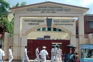
Structure

The academic institutes are classified in two types, one is a two-storied building and the other is a tin shed building.

Related Research Articles

Nangalkot Upazila Upazila in Chittagong Division, Comilla Bangladesh

Nangalkot is an Upazila, a administrative unit, of the Comilla District in the Division of Chittagong, Bangladesh. It is a rural area with no urban settlements. It has 11 unions, the lowest of administrative units in Bangladesh. It is one of the 16 upazilas, the second tier of administrative units, of the Comilla District.

Feni Sadar Upazila Upazila in Chittagong Division, Bangladesh

Feni Sadar is an Upazila of Feni District in the Division of Chittagong, Bangladesh. The district headquarters and all other administrative offices are located here. One of the main attractions of Feni Sadar is the shrine of the historically famous Pagla Miah, an 18th-century Muslim saint. Other historic sites include Rajajhee's Dighee and Bijoysingh Dighee, two large ponds of historical significance.

Sonagazi Upazila Upazila in Chittagong Division, Bangladesh

Sonagazi is an Upazila (sub-district) of Feni District in the Division of Chittagong, Bangladesh.

Companiganj Upazila, Noakhali Upazila in Chittagong Division, Bangladesh

Companiganj is an Upazila of Noakhali District in the Division of Chittagong, Bangladesh.

Senbagh Upazila Upazila in Chittagong Division, Bangladesh

Senbag is an upazila of Noakhali District in the Division of Chittagong, Bangladesh. Senbag is located within an area of 155.83 square kilometres (60.2 sq mi), which is enclosed by Nangalkot upazila, Noakhali Sadar and Companiganj upazilas (south), Daganbhuyiyan upazila, Feni (east), with Begumganj and Laksam upazilas.

Kalaroa Upazila Upazila in Khulna Division, Bangladesh

Kalaroa is an upazila of Satkhira District in the Division of Khulna, Bangladesh

Nasirabad Government High School

Nasirabad Government High School is one of the best government high schools in Bangladesh situated at East Nasirabad area in Chittagong, the port-city and the second largest city of the country. It is a male-only school with about 3000 students and conducts is educational activities in two different shifts of the day.

Matubhuiyan is a union parishad under Daganbhuiyan Upazila, Feni District, Chittagong Division, Bangladesh. It was established in 1959.

Chittagong Collegiate School and College

Chittagong Collegiate School and College is a government educational institution in Chittagong, the southern port city in Bangladesh. It provides education from 5th to 12th grade. Established in 1836, it is one of the oldest and one of the best educational institutes in the country. In 2016 Chittagong Collegiate School and College celebrated its 180 years of establishment.

Narayanganj High School & College, is one of the oldest educational institutions of Narayanganj. Since its establishment in 1885, Narayanganj High School served the motherland in many ways.

Agriculture Training Institute is a combined Government Technical College in Noakhali, a city in Bangladesh. It was established in 1947. It is situated in Chowrasta, Begumganj Upazila, Noakhali. This is an Agricultural Diploma institute.

Nilphamari Government High School is a government secondary school in Bangladesh in the city center of Nilphamari, headquarters of Nilphamari Sadar Upazila and Nilphamari District. In 2008 the school made a grand celebration of its 125th date of foundation.

Feni, Bangladesh Place in Chittagong Division, Bangladesh

Feni is a populated place in the Chittagong Division of southeastern Bangladesh. It is the headquarters of Feni Sadar Upazila and Feni District. Feni is the oldest municipality of this region, established in 1958.

Farhadabad High School

Farhadabad High School is an educational institution of Farhadabad Union of Hathazari Upazila in Chittagong, the southern port city in Bangladesh.It provides education for about 1500 students from 6th to 10th grade.Established in 1966,it is one of the oldest educational institutes in Hathazari upazila. In 2013,it celebrated its 45 year of establishment.

Board of Intermediate and Secondary Education, Comilla

The Board of Intermediate and Secondary Education, Cumilla is an autonomous organization that is responsible for holding public examinations in the Cumilla District and five nearby districts of Cumilla Division. The board was established in 1962 under the East Pakistan Intermediate and Secondary Education (Amendment) Ordinance, 1962.

Union Technical High School is a secondary educational institution situated at the village of Satani in Titas Upazila, Comilla District, Bangladesh. It was established in 1993. More than 1000 students from the nearby villages study in this school. The school provides education for five academic years. There is a large playground in front of the school.

Fatickchari Coronation Model High School is an old school in Bangladesh. It is situated at Fatickchari Upazila in Chittagong District. It is also known as Boys School, and also known as Boro (Great) School.

Lakshmipur-2 is a constituency represented in the Jatiya Sangsad of Bangladesh since 2019 by independent politician Shahidul Islam.

References

  1. "Secondary School" (XLS). Ministry of Education. Retrieved July 15, 2014.

Coordinates: 22°56′55″N91°19′45″E / 22.9486°N 91.3293°E / 22.9486; 91.3293

Geographic coordinate system Coordinate system

A geographic coordinate system is a coordinate system that enables every location on Earth to be specified by a set of numbers, letters or symbols. The coordinates are often chosen such that one of the numbers represents a vertical position and two or three of the numbers represent a horizontal position; alternatively, a geographic position may be expressed in a combined three-dimensional Cartesian vector. A common choice of coordinates is latitude, longitude and elevation. To specify a location on a plane requires a map projection.