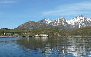
Skutvika or Skutvik is a small village in the municipality of Hamarøy in Nordland county, Norway. The village is situated at the southwestern extreme of the Hamarøya peninsula, about 90 kilometres (56 mi) north of the town of Bodø, 95 kilometres (59 mi) southwest of the town of Narvik, and 40 kilometres (25 mi) south of the town of Svolvær. To the west and south of Skutvik is the Økssundet, a sound connecting the Sagfjorden and Vestfjorden. The landscape in the immediate vicinity of the village is dominated by hills, while further north a row of mountains rises up to 950 metres (3,120 ft) above sea level.

Fjerdvatnet or Kråkmovatnet (Norwegian) or Skilggajávri (Lule Sami) is a lake in the municipality of Hamarøy in Nordland county, Norway. The European route E06 highway runs along the eastern shore of the lake. The lake lies about 12 kilometres (7.5 mi) southeast of the village of Tømmerneset. The large lake Rekvatnet lies just to the east and the lake Sandnesvatnet lies just to the north of this lake.
Kaldvågvatnet or Kallvågvatnet is a lake in the municipality of Hamarøy in Nordland county, Norway. It is located about 7 kilometres (4.3 mi) east of the municipal centre, Oppeid. The lake Skilvatnet lies immediately east of this lake.
Kilvatnet (Norwegian) or Ráhpukjávrre (Lule Sami) is a lake in the municipalities of Hamarøy and Tysfjord in Nordland county, Norway. The lake is located about 4 kilometres (2.5 mi) east of the village of Ulvsvåg.
Livsejávrre is a lake in the municipality of Hamarøy in Nordland county, Norway. It is located about 20 kilometres (12 mi) southeast of the village of Mørsvikbotn and about 6 kilometres (3.7 mi) west of the border with Sweden. The ending -jávrre is the Lule Sami language word for lake.
Reinoksvatnet (Norwegian) or Hierggejávrre (Lule Sami) is a lake in the municipality of Hamarøy in Nordland county, Norway. It is located about 20 kilometres (12 mi) east of the village of Mørsvikbotn and less than 2 kilometres (1.2 mi) west of the border with Sweden.
Rotvatnet or Nervatnet (Norwegian) or Ruohtsajávrre (Lule Sami) is a lake in the municipality of Hamarøy in Nordland county, Norway. The lake lies just west of the village of Tømmerneset. The European route E06 highway runs along the eastern shore of the lake. The lake Strindvatnet lies to the south of this lake.
Sandnesvatnet (Norwegian) or Sáttonjárgjávrre (Lule Sami) is a lake in the municipality of Hamarøy in Nordland county, Norway. The European route E06 highway runs along the eastern and northern shores of the lake. The lake lies about 5 kilometres (3.1 mi) southeast of the village of Tømmerneset. The lake Strindvatnet lies just to the northwest and the lake Fjerdvatnet lies to the south of the lake.
Šluŋkkajávri or Sluņkajávrre is a lake in the municipality of Hamarøy in Nordland county, Norway. The lake lies about 20 kilometres (12 mi) southeast of the village of Tømmerneset. The large lake Rekvatnet lies just to the west of this lake. The ending -jávri or -jávrre is the Sami language word for lake.
Oppeid or Oppeide is the administrative centre of Hamarøy Municipality in Nordland county, Norway. The village is located about 90 kilometres (56 mi) southwest of the town of Narvik. It is located right next to the village of Presteid on a small isthmus of land between the Kaldvågfjorden and the Presteidfjorden. The village is home to the Knut Hamsun videregående skole, a museum, and cafe.
Finnøya is an island in Hamarøy Municipality in Nordland county, Norway. The island is situated northwest of the village of Innhavet with which it is connected by bridge. The mountainous island has an area of 68 square kilometres (26 sq mi) and the highest point is the 436-metre (1,430 ft) tall mountain Straumfjellet. In 2016, the island of Finnøya had a population of 75.
Tranøy or Tranøya is a village and ancient trade centre in the municipality of Hamarøy in Nordland county, Norway. It is located on the end of a peninsula about 14 kilometres (8.7 mi) north of the municipal centre, Oppeid. The Tranøy Lighthouse is located west of the village on a small islet connected to the mainland by a pedestrian bridge.

Tømmerneset is a village in the municipality of Hamarøy in Nordland county, Norway. It's located on the eastern shore of the lake Rotvatnet, about 50 kilometres (31 mi) south of the municipal centre, Oppeid. Tømmerneset is the site of Tømmernes Church. The village area is located where County Road 835 branches off from the European Road E6 highway.

Presteid is a village in the municipality of Hamarøy in Nordland county, Norway. It is located immediately east of the village of Oppeid, along the Presteidfjorden. Presteid is part of the Oppeid urban area which has a population (2018) of 551.

Hamarøy Church is a parish church of the Church of Norway in Hamarøy Municipality in Nordland county, Norway. It is located in the village of Presteid. It is the church for the Hamarøy parish which is part of the Ofoten prosti (deanery) in the Diocese of Sør-Hålogaland. The white, modern, concrete church was built in a fan-shaped style in 1974 by the architect Nils Toft. The church seats about 400 people.
Sagfjord Church is a parish church of the Church of Norway in Hamarøy Municipality in Nordland county, Norway. It is located in the village of Karlsøy on the island of Finnøya. It is the church for the Sagfjord parish which is part of the Ofoten prosti (deanery) in the Diocese of Sør-Hålogaland. The white, wooden church was built in a long church style in 1886 by the architect S. Mathisen. The church seats about 130 people.

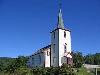
Tømmerneset Church is a parish church of the Church of Norway in Hamarøy Municipality in Nordland county, Norway. It is located in the village of Tømmerneset. It is the church for the Sagfjord parish which is part of the Ofoten prosti (deanery) in the Diocese of Sør-Hålogaland. The white, wooden church was built in a long church style in 1952 by the architect Eiliv Dahl. The church seats about 110 people.
Tranøy or Tranøya may refer to:

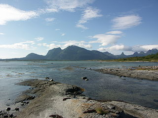
Sagfjorden (Norwegian) or Rivtakvuodna (Northern Sami) is a fjord in Nordland county, Norway. The 38-kilometre (24 mi) long fjord forms part of the boundary between the municipalities of Hamarøy and Steigen. There are several large islands in the fjord as well: Finnøya to the north and Lundøya and Engeløya at the mouth of the fjord where it joins the Vestfjorden.


