
The Tian Shan, also known as the Tengri Tagh or Tengir-Too, meaning the "Mountains of God/Heaven", is a large system of mountain ranges in Central Asia. The highest peak is Jengish Chokusu at 7,439 metres (24,406 ft) high. Its lowest point is the Turpan Depression, which is 154 m (505 ft) below sea level.

The Ili River is a river in Northwest China and Southeastern Kazakhstan. It flows from the Ili Kazakh Autonomous Prefecture of the Xinjiang Uighur Autonomous Region to the Almaty Region in Kazakhstan.

The Dzungarian Alatau is a mountain range that lies on the boundary of the Dzungaria region of China and the Zhetysu region of Kazakhstan. It has a length of 450 km (280 mi) and a maximum elevation of 4,464 m (14,646 ft).

Almaty Region, formerly known as the Alma-Ata Region until 1993, is a region in Kazakhstan, located in the southeastern part of the country. Its capital, from 1997 to 2022 was the city of Taldyqorğan. But with the new creation of Jetysu Region in 2022, Taldyqorğan was chosen to be its capital, and the capital of Almaty Region was moved to the city of Qonaev.

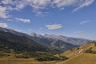
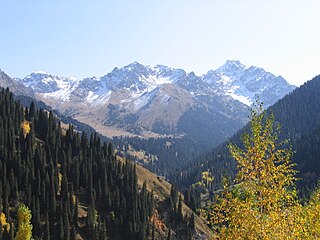
Ile Alatau, also spelt as Trans-Ili Alatau, is a part of the Northern Tian Shan mountain system in Kazakhstan and Kyrgyzstan. It is the northernmost mountain range of Tian Shan, stretching for about 350 km (220 mi) with a maximal elevation of 4,973 m (16,316 ft). The term "Alatau" refers to a kind of mountain. The range is bounded in the north by the Ili Depression of the Ili River, hence the name.
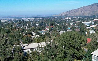
Talgar is a town in Almaty Region, southeastern Kazakhstan. It is the administrative center of Talgar District. The town is located between Almaty and Esik, 25 km from Almaty and several kilometres east of Birlik. Population: 45,529 ; 43,353.

Ile-Alatau National Park is a national park in Kazakhstan. It was created in 1996 and covers about 200,000 ha. It is situated in the Trans-Ili Alatau mountains south of Almaty between Gorge Turgen in the east and Chemolgan River in the west. The national park borders Almaty Nature Reserve, which is located around Pik Talgar.

Big Almaty Lake is natural alpine reservoir. It is located in the Trans-Ili Alatau mountains, 15 km south from the center of Almaty in Kazakhstan. The lake is 2511 meters above sea level.

Kolsay Lakes National Park is located on the north slope of the Tian Shan Mountains, southeast Kazakhstan. Often referred to as "Pearls of Tien Shan", the park's main feature are the Kolsay Lakes located between the Raiymbek District and Talgar District of Almaty Region. The scenic Lake Kaindy is also within the park. The park boundary is 120 kilometres (75 mi) southeast of Almaty. Lakes of landslide-tectonic origin, approximately formed in 1887 and 1911 on the Kaindy and Kolsay rivers.

Zhongar-Alatau National Park, also Jungar Alatau, or Dzungurian Alatau, was created in 2010 to protect the unique ecology of the Dzungarian Alatau, an isolated, glaciated mountain range in Kazakhstan, on the southeastern border with China. One stated reason for creating the park is to protect forests of wild fruit trees, including apricots, barberry, cherries, and currants. Approximately 1% of the land area of the park is forested with Sievers Apple trees, which are the progenitors of all cultured apple varieties in the world. The park is 300 km long (west-to-east), and spreads across Aksu District, Sarkand District and Alakol District of Almaty Region, 300 km northeast of the regional city of Almaty.
Kok Zhailau is a plateau in the Trans-Ili Alatau. It is located at an altitude of 1,450 m (4,760 ft) to 1,740 m (5,710 ft) between the Small and Big Almaty gorges, 10 km from the city of Almaty.

Konstantin Grigorievich Makarevich was a Soviet and Kazakhstani glaciologist. He made a significant scientific contribution to the development and popularization of glaciology. He headed the Soviet glaciological expedition on the Tuyuksu glacier from 1956 to 1992 and was the founder of the Tuyuksu glaciological station. For more than 20 years, he was as an official representative of the Soviet Union in the World Glacier Monitoring Service (WGMS). He authored more than 200 scientific articles, monographs, regional and autobiographical books, and essays. Two glaciers and two passes in the Trans-Ili and Dzhungarian Alatau are named after him. He was a veteran of World War II, an order-bearer.
The waterfall is located in a deep and narrow rock canyon in Kazakhstan, 400 meters from the main gorge. The canyon has a narrow possibility that it is necessary to move along the riverbed. A stream of water escapes from the rock wall at a height of about 20 meters. In terms of its height, water consumption and power, the Big Shymbulak waterfall is comparable to the Medvezhy waterfall in the Turgen gorge. Heavy spring precipitation also helps to increase the power of the waterfall, compared with the summer or autumn period, it is not easy to get close to the waterfall, in a few seconds you get soaked to the skin, and all this thanks to water dust. But if you cross the river, then there is not a large observation deck on the hill, where it is relatively dry. Flowing down, the water dug a deep bath at the bottom of the gorge, up to 2 meters deep. The water in this reservoir is very cold even on the hottest day, as it has a glacial origin. Spruce forests in the gorge are absent throughout its entire length. In the lower belt grows apricot and shrubs, barberry, rose hips, and other Shrubs are very prickly. For multi-day hikes, this is a big minus — the lack of firewood. Shrub vegetation is present on the slopes up to the heights of 2200–2400 m of the confluence with the Maybulak river.

Kairak Falls is a waterfall on the Kairak River in the Enbekshikazakh District in the south of Almaty Region of Kazakhstan on the right tributary of the Turgen River. The source of the river is located in the glaciers of the central part of the Zailiysky Alatau ridge, near the border of Enbekshikazakh and Talgar districts of Almaty region. It flows through the territory of the Ile-Alatau National Park, the prevailing direction of flow is north — northwest. Approximately about ten thousand years ago, the right tributary of the Turgen Bozgul river broke through a tunnel in the rocks, thereby forming the most powerful and unique waterfall in the T-ili Alatau. The Kairak waterfall is located on the northern slope of the Zailiysky Alatau mountain range in the OI-Karagay tract. The waterfall is located at an altitude of 2,130 m (6,990 ft) above sea level. The height of the water fall is about 55 m (180 ft), with thresholds 74 m (243 ft). The height exceeds the famous Niagara Falls in North America at 53 m (174 ft) The waterfall got its name not by chance. Kairak-translated from the Kazakh language-is a "sharpener", it literally cut its way into the gorge.

Ayusay gorge is a left branch from the Big Almaty gorge (BAU), about 6–7 km long, starting a little East of the top of the Big Almaty peak. The monument is located on the territory of the state national natural Park Ile-Alatau.
The Monakhovo gorge is a canyon in Kazakhstan. It is so named because in the early 1920s Orthodox schemers hid in caves here from the Bolsheviks. They were huddled in a crevice in the rock where they had built a small Church. But either by someone's report, or by carelessness, they were noticed by the authorities. The monks were shot, and the cave with the Church inside was blown up. Now there is only a shallow passage at the entrance to the rock's hiding place.
Butakovsky gorge is located on the Northern slope of the Zailiysky Alatau ridge in the watershed of The Little (Malaya) Almatinka basin and the Left Talgar, Kazakhstan.
Almaty State Natural Reserve is a 71,700 ha (177,000-acre) nature reserve in the Almaty Region, Kazakhstan, in the central part of the Trans-Ili Alatau ridge. In 1966, the “Singing Mountain” desert area was added to the reserve, but in January 1983 the natural monument was placed under the jurisdiction of the Kapchagai Hunting Sector. The area is located within the territory of the Altyn-Emel National Park.
The Medeu gorge is a territory located in the valley of Malaya Almatinka River, in foothills of Trans-Ili Alatau ridge at an altitude of 1520–1750 meters, 14 km to the southeast of center of Almaty. The natural boundaries of gorge territory are: Kimasar mountain spur separating the basins of Malaya Almatinka and Butakovka rivers, to the east - Kabyrgatau separating the gorges of Kimasar and Sarysai rivers, to the south-west - Kumbel peak. On territory of the gorge in 1966 a mudflow protection Medeu Dam was built, below which is located the Medeu high-mountain sports complex. The Medeo hotel was formerly located near the Medeu rink, until it was demolished in the early 2000s.
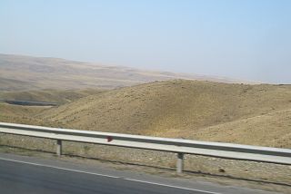
The Chu-Ili Range is a mountain range in Kazakhstan. Administratively it is part of the Almaty and Zhambyl regions.