Kastro tis Orias (ballad)

Last updated

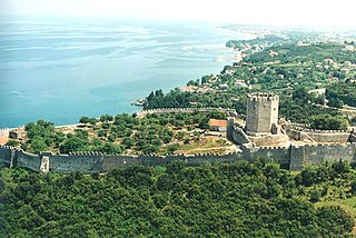
The Kastro tis Orias (Greek : Κάστρο της Ωριάς, "Castle of the Fair Maiden") or Kastro tis Marous (Κάστρο της Μαρούς, "Castle of Maria") is a Greek ballad about a fair maiden who fell from the battlements of her castle to her death when it was taken by an enemy, typically Saracens or Ottomans. In many versions, it has been known throughout the Greek world since the Middle Ages. The name has been applied to many fortifications across the Greek world (cf. Kastro tis Orias).

Greek language language spoken in Greece, Cyprus and Southern Albania

Greek is an independent branch of the Indo-European family of languages, native to Greece, Cyprus and other parts of the Eastern Mediterranean and the Black Sea. It has the longest documented history of any living Indo-European language, spanning more than 3000 years of written records. Its writing system has been the Greek alphabet for the major part of its history; other systems, such as Linear B and the Cypriot syllabary, were used previously. The alphabet arose from the Phoenician script and was in turn the basis of the Latin, Cyrillic, Armenian, Coptic, Gothic, and many other writing systems.

The Greeks or Hellenes are an ethnic group native to Greece, Cyprus, southern Albania, Italy, Turkey, Egypt and, to a lesser extent, other countries surrounding the Mediterranean Sea. They also form a significant diaspora, with Greek communities established around the world.

Ballad form of verse, often a narrative set to music

A ballad is a form of verse, often a narrative set to music. Ballads derive from the medieval French chanson balladée or ballade, which were originally "danced songs". Ballads were particularly characteristic of the popular poetry and song of Ireland and Britain from the later medieval period until the 19th century. They were widely used across Europe, and later in Australia, North Africa, North America and South America. Ballads are often 13 lines with an ABABBCBC form, consisting of couplets of rhymed verse, each of 14 syllables. Another common form is ABAB or ABCB repeated, in alternating 8 and 6 syllable lines.

The ballad may originally have been based on the Sack of Amorium (838); the characteristics of the citadel of Amorium (near modern Emirdağ, Turkey) seem to be mentioned, especially in the version called "To Kastro tis Marous". [1]

Sack of Amorium historical event

The Sack of Amorium by the Abbasid Caliphate in mid-August 838 was one of the major events in the long history of the Arab–Byzantine Wars. The Abbasid campaign was led personally by the Caliph al-Mu'tasim, in retaliation to a virtually unopposed expedition launched by the Byzantine emperor Theophilos into the Caliphate's borderlands the previous year. Mu'tasim targeted Amorium, a Byzantine city in western Asia Minor, because it was the birthplace of the ruling Byzantine dynasty and, at the time, one of Byzantium's largest and most important cities. The caliph gathered an exceptionally large army, which he divided in two parts, which invaded from the northeast and the south. The northeastern army defeated the Byzantine forces under Theophilos at Anzen, allowing the Abbasids to penetrate deep into Byzantine-held Asia Minor and converge upon Ancyra, which they found abandoned. After sacking the city, they turned south to Amorium, where they arrived on 1 August. Faced with intrigues at Constantinople and the rebellion of the large Khurramite contingent of his army, Theophilos was unable to aid the city.

Amorium ancient City, today in Turkey

Amorium was a city in Phrygia, Asia Minor which was founded in the Hellenistic period, flourished under the Byzantine Empire, and declined after the Arab sack of 838. It was situated on the Byzantine military road from Constantinople to Cilicia. Its ruins and höyük are located under and around the modern village of Hisarköy, 13 kilometers east of the district center, Emirdağ, Afyonkarahisar Province, Turkey.

Emirdağ City in Turkey

Emirdağ is a town and district of Afyonkarahisar Province in Turkey, between the city of Afyon and Eskişehir. The district covers an area of 2,009 km², and the population (2014) is 38,269 of which 19,093 live in the town of Emirdağ itself. The mayor is Cengiz Pala (AKP).

Plot

A castle is besieged for many years. One of the besiegers, whose mother is Greek, disguises himself as a pregnant Greek woman who wants to give birth or as a monk who wants to take refuge. The lady of the castle (the "fair maiden") takes pity and orders the gate to be opened. The besiegers pour in and the trickster chases after her as his prize, but she throws herself off the ramparts and dies.

Notes

  1. Aikaterinē Christophilopoulou, Byzantine History, 1986, ISBN   9025610447 2:249


Related Research Articles

Kastro-Kyllini Place in Greece

Kastro-Kyllini is a former municipality in Elis, West Greece, Greece. Since the 2011 local government reform it is part of the municipality Andravida-Kyllini, of which it is a municipal unit. The municipal unit has an area of 49.322 km2. The population was 3,622 in 2011. The municipality Kastro-Kyllini was created in 1999 as part of the Kapodistrias reform from the formerly independent communities Kyllini, Kato Panagia, Kastro and Neochori, that became municipal districts. After the 2011 Kallikratis reform, these municipal districts became (dependent) communities. Its seat of administration was the small port town of Kyllini.

Military history of Greece

The military history of Greece is the history of the wars and battles of the Greek people in Greece, the Balkans and the Greek colonies in the Mediterranean Sea and the Black Sea since classical antiquity.

Grand Ma[i]gne or Vieux Ma[i]gne was a Frankish castle in the Mani Peninsula, Greece. It was built, according to the Chronicle of the Morea, ca. 1248–1250 AD by William II Villehardouin, the Prince of Achaea in order to control the Slavic tribe of the Melingoi, living on Mount Taygetos. He was captured by the Byzantines in 1259 at the Battle of Pelagonia, and had to give up the castle as part of his ransom.

Chios, North Aegean Place in Greece

Chios is the main town and a former municipality on the island of Chios, North Aegean, Greece. Since the 2011 local government reform, it is part of the municipality Chios, of which it is a municipal unit. The municipal unit has an area of 22.823 km2. It is located on the eastern coast of the island facing the Turkish coastal town of Çeşme. The town has a population of 26,850 (2011) and is the administrative capital and main port of both the island and of the regional unit of Chios. Chios town is one of eight municipal units on the island.

"The Fair Flower of Northumberland" is a folk ballad.

"The Broomfield Hill", "The Broomfield Wager" "The Merry Broomfield", "The Green Broomfield", "A Wager, a Wager", or "The West Country Wager" (Child 43, Roud 34) is a traditional English folk ballad.

Galata, Cyprus Place in Nicosia District, Cyprus

Galata is a village in the Solea valley, located about 60 km west of the capital Nicosia, at an altitude of 620 m in the Troodos Mountains of Cyprus. It is a popular summer tourist destination for its cooler climate in the summer months. It is also well known on the island for its fruit produce. In Galata there is Panagia tis Podithou, church, which is a UNESCO World Heritage Site along with nine other Painted Churches in the Troödos Region.

Cynaetha or Kynaitha, or Cynaethae or Kynaithai (Κύναιθαι), was a town in the north of ancient Arcadia, situated upon the northern slope of the Aroanian Mountains, which divided its territory from those of Cleitor and Pheneus. It was the northernmost town of Arcadia; the inhabitants of Cynaetha were the only Arcadians who lived beyond the natural boundaries of Arcadia. Their valley sloped down towards the Corinthian Gulf; and the river which flowed through it fell into the Corinthian Gulf a little to the east of Bura: this river was called in ancient times Erasinus or Buraicus, now the river of Vouraikos. The climate and situation of Cynaetha are described by Polybius as the most disagreeable in all Arcadia. The same author observes that the character of the Cynaethians presented a striking contrast to that of the other Arcadians, being a wicked and cruel race, and so much disliked by the rest of their countrymen, that the latter would scarcely hold any intercourse with them. He attributes their depravity to their neglect of music, which had tended to humanize the other Arcadians, and to counteract the natural rudeness engendered by their climate. Accordingly, he regarded the terrible misfortune which overtook the Cynaethians in the Social War, when their city was destroyed by the Aetolians, as a righteous punishment for their wickedness. Although Strabo mentions Cynaetha as one of the Arcadian towns no longer existing in his time, it must have been restored at some period after its destruction by the Aetolians, as it was visited by Pausanias, who noticed in the agora altars of the gods, a sanctuary of Dionysus, and a statue of the emperor Hadrian. The Cynaetheans gave to Olympia the statue of Zeus which held a thunderbolt in his hand. At the distance of two stadia from the town was a fountain of cold water, called Alyssus (Άλυσσος), because it was said to cure rabies.

Salmeniko Castle human settlement in Greece

The Salmeniko Castle or Orgia or Oria Castle was a castle at the foot of Panachaiko mountain, in the modern municipality of Aigialeia, Achaea, Greece.

Patras Castle

The Patras Fortress was built around the mid-6th century above the ruins of the ancient acropolis, on a low outlying hill of the Panachaiko Mountain and ca. 800 m from the sea. The castle covers 22,725 m² and consists of a triangular outer wall, strengthened by towers and gates and further protected originally by a moat, and an inner compound on the northeastern corner, also protected by a moat.

Princess Argjiro or Argyro is a legendary figure in Albanian and Greek mythology. She is supposed to have lived in the 15th century.

Platamon Castle fortification

The Platamon Castle, an important part of the history of Pieria, is a Crusader castle in northern Greece (Macedonia) and is located southeast of Mount Olympus, in a strategic position which controls the exit of the Tempe valley, through which passes the main road connecting Macedonia with Thessaly and southern Greece. The tower (donjon), which overlooks the highway, is an imposing medieval fortress.

Kastro tis Orias may refer to:

Dryalos (Δρύαλος) or Dry (Δρυ) is a village in the municipal unit of Oitylo, Laconia, Peloponnese, Greece.

Kastro, Thasos

Kastro is a small village in the interior of the Greek island of Thassos. It is believed to be the oldest village on the island. The village name comes from the old castle that existed here to protect the inhabitants. The village is located in the centre of the island, at a height of 450–500 m above sea level. It can be reached from Limenaria on an asphalt road or from Theologos on dirt road.

Siderokastron was a medieval fortified settlement on Mount Oeta in Central Greece.

Skiathos Castle or simply Kastro is a medieval fortified site on the northern tip of the island of Skiathos in Greece, which was the main settlement of the island from the mid-14th century to 1829. It is now abandoned and a protected site.

Assos Castle castle in Greece

The Assos Castle is a Venetian fortification on Cephalonia island in western Greece.

Oktonia Place in Greece

Oktonia is a hillside village found in the east-central area of Evia Island, belonging to the Municipality of Kimi-Aliveri. Located near the lower side of the Gulf of Kimi, the village is composed of four communities, Alonia, Panochori, Katochori and Panagia, covering a large area. It is 145 km from Athens, a distance covered in about 2.5 hours by car, making it a destination for both winter and summer holidays. According to the census of 2011, Oktonia has 455 permanent inhabitants.