
The Katy Trail is a rail trail that runs through the Uptown and Oak Lawn areas of Dallas, Texas (USA). It follows the former rail bed of the Missouri-Kansas-Texas Railroad, previously known as the MKT road or "Katy".
The Katy Trail is a rail trail that runs through the Uptown and Oak Lawn areas of Dallas, Texas (USA). It follows the former rail bed of the Missouri-Kansas-Texas Railroad, previously known as the MKT road or "Katy".
This article's tone or style may not reflect the encyclopedic tone used on Wikipedia.(January 2022) |
In Dallas, abandoned railroad tracks that once divided the downtown core are being transformed into the unifying Katy Trail, a linear, 3.5-mile long (5.6 km) landscaped trail system that runs through the most densely-developed section of the city. Construction on the trail began in the spring of 2000. As of 2022, several features have already been completed, including the 12-foot wide (3.7 m) primary trail, two of four planned entrance plazas, and four of the six planned pedestrian bridges. Construction was completed in 2007 on the Thomsen Overlook plaza, overlooking Reverchon Park. An 8-foot wide (2.4 m) secondary jogging trail has 1 mile (1.6 km) left of construction, which will be completed once more funding is secured. The work is being carried out by The Friends of Katy Trail under a master plan created by The SWA Group office in Dallas. [1]

The trail consists of a 12-foot-wide (3.7 m) concrete path for pedestrians and cyclists that runs 3.5 miles (5.6 km) from American Airlines Center in Victory Park to Mockingbird Station (a DART light rail station) near Southern Methodist University. A soft, recycled rubber track, used for running, parallels the concrete path.
This adaptive re-use of unused railroad tracks unifies several important Dallas districts and provides a major recreational amenity for the more than 300,000 people who live and work within a mile of the trail (The Southernmost Trail-head is 0.5 miles (800 m) from downtown Dallas at the American Airlines Center). This new, partly completed linear greenway is already popular among pedestrians and nature-lovers, both Dallas residents and visitors.
The Katy Trail is also directly responsible for an upsurge in property values and retail-restaurant sales in adjacent neighborhoods and developments. [2] On April 21, 2006, The Dallas Morning News called Katy Trail "one of our city’s favorite outdoor spaces".[ attribution needed ] Katy Trail has become such a popular jogging location that some Dallas citizens quip, "The trains don’t run here anymore...Dallas does."[ attribution needed ]
The trail's life began when the Union Pacific Railroad, which had bought the Katy, donated the abandoned lines to the city in 1993. The train tracks that are now the location of the Katy Trail, formed the major eastbound route through Dallas of the former Missouri-Kansas-Texas (MKT or "Katy") Railroad, which shut down this segment of its network in the late 1980s. The stations, which had served Dallas residents on their trips east for so many years, were torn down, but the tracks remained.
In the early 1980s, The Katy was initially considered for DART's Red and Blue lines to the Northeast, but the current route beneath Central Expressway was chosen instead.
By the early 1990s, Dallas residents, businesspeople, and city and county officials proposed restoring the greenbelt along the railroad route and creating an urban park as part of the national Rails-to-Trails Conservancy program, established in 1986 and based in Washington, D.C.


Since Friends of the Katy Trail was formed in 1997, this trail has become a civic point of pride in Dallas. The trail, though a public park, is privately maintained. Each year, Friends of the Katy Trail runs an Annual Support Campaign to solicit donations for the trail. In 2007, the capital campaign (which raised funds for both ongoing trail maintenance and trail expansion) netted a high of more than $2 million, while in other years it has fluctuated closer to $1 million. Although private donations are a major source of support for trail maintenance, they are complemented by government and foundation grants. [3]
The Katy Trail is intended to provide an effective way of connecting the various Dallas city parks running from White Rock Lake to the Trinity River Project park system along the Trinity River. The rail trail runs alongside Reverchon Park and the parks system along Turtle Creek, a tributary of the Trinity River.
Originally, the Dallas Park & Recreation Department planned a basic concrete pathway system along the railroad right of way. The Friends of the Katy Trail have greatly expanded that vision by hiring The SWA Group, an international landscape architecture, planning, and urban design firm, to create a $23 million master plan for two trails and an urban park connecting the West End district to Mockingbird Station.

Katy Trail is aspiring to have a 3.5-mile-long (5.6 km), 12-foot-wide (3.7 m) concrete path for bicyclists and in-line skaters, an adjacent 3.1-mile-long (5.0 km), 8-foot-wide (2.4 m) soft-surface track for pedestrians, four major entrance plazas, ADA-compliant entrances, benches, landscaping, and drinking fountains for all users, including pets. It will be connected to the Trinity Strand Trail. [4]
The planting plan is dominated by native Texas trees and plants, including chinkapin and Lacey oaks, perennial grasses, Flame Acanthus, and numerous species of native salvias and other plans which support water conservation.
For years, the abandoned railroad tracks have been left in a state of disrepair, but the master plan includes strategies to transform negative public perceptions of the Katy Trail through landscaping, lighting, and in particular, the design of nine public spaces at important crossings and intersections. For night-time safety without adding light pollution, reflective shield lamps atop 25-foot (7.6 m) poles direct light onto the trail. The public spaces also have more intimate lighting and distinctive light fixtures.
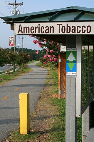
The American Tobacco Trail (ATT) is a 22.6-mile (36.4 km) long Rails-to-Trails project located in the Research Triangle region of North Carolina, running along an abandoned railroad bed originally built for the American Tobacco Company in the 1970s. The route crosses through portions of Durham County, Chatham County, and Wake County. The ATT is part of the East Coast Greenway and is open to pedestrians, cyclists, equestrians and other non-motorized users.

The Katy Trail State Park is a state park in the U.S. state of Missouri that contains the Katy Trail, the country's longest continuous recreational rail trail. It runs 240 miles (390 km), largely along the northern bank of the Missouri River, in the right-of-way of the former Missouri–Kansas–Texas Railroad. Open year-round from sunrise to sunset, it serves hikers, joggers, and cyclists. Its hard, flat surface is of "limestone pug".
The Missouri–Kansas–Texas Railroad was a Class I railroad company in the United States, with its last headquarters in Dallas, Texas. Established in 1865 under the name Union Pacific Railroad (UP), Southern Branch, it came to serve an extensive rail network in Texas, Oklahoma, Kansas, and Missouri. In 1988, it merged with the Missouri Pacific Railroad; today, it is part of UP.

A rail trail is a shared-use path on railway right of way. Rail trails are typically constructed after a railway has been abandoned and the track has been removed but may also share the right of way with active railways, light rail, or streetcars, or with disused track. As shared-use paths, rail trails are primarily for non-motorized traffic including pedestrians, bicycles, horseback riders, skaters, and cross-country skiers, although snowmobiles and ATVs may be allowed. The characteristics of abandoned railways—gentle grades, well-engineered rights of way and structures, and passage through historical areas—lend themselves to rail trails and account for their popularity. Many rail trails are long-distance trails, while some shorter rail trails are known as greenways or linear parks.
The Monon Trail is a rail trail located entirely within the state of Indiana. The Monon Railroad was a popular railroad line connecting the cities of Chicago and Indianapolis, with stops at major settlements along its route. After the decline of railroad travel and the sale of the company in 1987, the portion of the line between Indianapolis and Delphi, Indiana, was abandoned.

A greenway is usually a shared-use path along a strip of undeveloped land, in an urban or rural area, set aside for recreational use or environmental protection. Greenways are frequently created out of disused railways, canal towpaths, utility company rights of way, or derelict industrial land. Greenways can also be linear parks, and can serve as wildlife corridors. The path's surface may be paved and often serves multiple users: walkers, runners, bicyclists, skaters and hikers. A characteristic of greenways, as defined by the European Greenways Association, is "ease of passage": that is that they have "either low or zero gradient", so that they can be used by all "types of users, including mobility impaired people".
The Baltimore & Annapolis Trail is a 13.3-mile (21.4 km) rail trail in Anne Arundel County, Maryland. The trail starts at Boulter's Way in Arnold and ends near Baltimore Light Rail's Glen Burnie station in Glen Burnie. Starting near Annapolis at Jonas Green Park, the trail passes (northward) through Arnold, Severna Park, Millersville, Pasadena, and Glen Burnie. The Baltimore & Annapolis Trail follows the route of the Baltimore & Annapolis Railroad from which it derives its name. Proposed in 1972 by Jim Hague, it opened on Oct 7, 1990 as the second rail trail in Maryland.

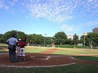
Hermann Park is a 445-acre (180-hectare) urban park in Houston, Texas, situated at the southern end of the Museum District. The park is located to the immediate north end of the MD Anderson Cancer Center at Texas Medical Center and Brays Bayou, east of Rice University, and slightly west of the Third Ward. Hermann Park is home to numerous cultural institutions including the Houston Zoo, Miller Outdoor Theatre, the Houston Museum of Natural Science, and the Hermann Park Golf Course, which became one of the first desegregated public golf courses in the United States in 1954. The park also features the Mary Gibbs and Jesse H. Jones Reflection Pool, numerous gardens, picnic areas, and McGovern Lake, an 8-acre (32,000 m2) recreational lake.
This article is about transportation systems in and around Dallas, Texas (USA).
The Klickitat Trail is a 31-mile (50 km) rail trail along the Klickitat River in southern Washington in the Columbia River Gorge. The cycling and hiking trail offers river and canyon views throughout its length. It follows an old railroad corridor that at one time linked the towns of Lyle and Goldendale.
Reverchon Park is a public park in the Oak Lawn area of Dallas, Texas. It was named for the French botanist Julien Reverchon.

The Cape Cod Rail Trail (CCRT) is a 25.5-mile (41.0 km) paved rail trail located on Cape Cod in Massachusetts. The trail route passes through the towns of Yarmouth, Dennis, Harwich, Brewster, Orleans, Eastham, and Wellfleet. It connects to the 6-plus mile (10 km) Old Colony Rail Trail leading to Chatham, the 2 mile Yarmouth multi-use trail, and 8 miles (13 km) of trails within Nickerson State Park. Short side trips on roads lead to national seashore beaches including Coast Guard Beach at the end of the Nauset Bike Trail in Cape Cod National Seashore. The trail is part of the Claire Saltonstall Bikeway.

The Wallkill Valley Rail Trail is a 23.7-mile (38.1 km) rail trail and linear park that runs along the former Wallkill Valley Railroad rail corridor in Ulster County, New York, United States. It stretches from Gardiner through New Paltz, Rosendale and Ulster to the Kingston city line, just south of a demolished, concrete Conrail railroad bridge that was located on a team-track siding several blocks south of the also-demolished Kingston New York Central Railroad passenger station. The trail is separated from the Walden–Wallkill Rail Trail by two state prisons in Shawangunk, though there have been plans to bypass these facilities and to connect the Wallkill Valley Rail Trail with other regional rail-trails. The northern section of the trail forms part of the Empire State Trail.
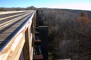
High Bridge Trail State Park is a rail trail in Southside Virginia converted from a rail line last belonging to Norfolk Southern.

The Camp Chase Railway is a short-line switching and terminal railroad in and near Columbus, Ohio, United States, running past the former Camp Chase. The company was formed as the Camp Chase Industrial Railroad in 1994 as a spin-off of Conrail. Through trackage rights, the railroad interchanges with Norfolk Southern Railway and CSX at Buckeye Yard. The Camp Chase bike trail follows alongside the railroad for 12 miles and is one the few trails in the United States that runs within an active railroad right-of-way.

The Palatka-Lake Butler State Trail (PLB) corridor stretches nearly 47 miles (76 km) from the vicinity of Lake Butler, Florida to Palatka, Florida. The project is located along the former Georgia Southern and Florida Railway right-of-way and the trail is being constructed on top of the existing abandoned railroad bed through Putnam, Clay, Bradford, and Union counties.

The Frederik Meijer M-6 Trail, formerly called the M-6 Trail, is a rail trail in Kent County, Michigan. It connects the Paul Henry–Thornapple Rail Trail with the Kent Trails in Byron Township, Michigan.

The Northaven Trail is a 8.2 mile hike/bike commuter and recreational trail that runs through the northern neighborhoods in Dallas, Texas. Currently, the trail connects the neighborhoods from Central Expressway (US75) to Denton Drive and the Dallas DART station. It provides a recreational resource for the area as well as providing east / west transportation alternatives. The trail is part of the greater Dallas Parks Department and part of the Texas Department of Transportation’s and Dallas City Council's plan to increase alternative means of transportation throughout the city.