At 824,292 km2 (318,261 sq mi), Namibia is the world's thirty-fourth largest country. After Mongolia, Namibia is the second least densely populated country in the world.
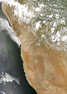
The Namib is a coastal desert in Southern Africa. The name Namib is of Khoekhoegowab origin and means "vast place". According to the broadest definition, the Namib stretches for more than 2,000 kilometres (1,200 mi) along the Atlantic coasts of Angola, Namibia, and South Africa, extending southward from the Carunjamba River in Angola, through Namibia and to the Olifants River in Western Cape, South Africa. The Namib's northernmost portion, which extends 450 kilometres (280 mi) from the Angola-Namibia border, is known as Moçâmedes Desert, while its southern portion approaches the neighboring Kalahari Desert. From the Atlantic coast eastward, the Namib gradually ascends in elevation, reaching up to 200 kilometres (120 mi) inland to the foot of the Great Escarpment. Annual precipitation ranges from 2 millimetres (0.079 in) in the most arid regions to 200 millimetres (7.9 in) at the escarpment, making the Namib the only true desert in southern Africa. Having endured arid or semi-arid conditions for roughly 55–80 million years, the Namib may be the oldest desert in the world and contains some of the world's driest regions, with only western South America's Atacama Desert to challenge it for age and aridity benchmarks.

The Herero Wars were a series of colonial wars between the German Empire and the Herero people of German South West Africa. They took place between 1904 and 1908.

Lüderitz is a town in the ǁKaras Region of southern Namibia. It lies on one of the least hospitable coasts in Africa. It is a port developed around Robert Harbour and Shark Island.

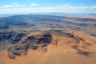
The Namib-Naukluft Park is a national park in western Namibia, situated between the coast of the Atlantic Ocean and the edge of the Great Escarpment. It encompasses part of the Namib Desert, the Naukluft mountain range, and the lagoon at Sandwich Harbour. The best-known area of the park and one of the main visitor attractions in Namibia is Sossusvlei, a clay pan surrounded by dunes, and Sesriem, a small canyon of the Tsauchab. The desert research station of Gobabeb is situated within the park.

Franz Adolf Eduard Lüderitz was a German merchant and the founder of German South West Africa, Imperial Germany's first colony. The coastal town of Lüderitz, located in the ǁKaras Region of southern Namibia, is named after him.
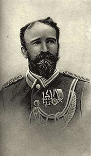
Curt Karl Bruno von François was a German geographer, cartographer, Schutztruppe officer and commissioner of the imperial colonial army of the German Empire, particularly in German South West Africa where he was responsible on behalf of Kaiser for the foundation of the city of Windhoek on 18 October 1890 and the harbor of Swakopmund on 4 August 1892.

Duwisib Castle, sometimes spelt Duwiseb or Duweseb, is a grand pseudo-medieval looking fortress in the hills of the semi-arid Southern Namib region of Namibia, 72 km southwest of Maltahöhe, Hardap Region. It was built in 1909 to serve as the residence of Hans Heinrich von Wolf, a German military officer. Since 1979 the castle has been owned by the government.

The Swakop River is a major river in western central Namibia. Its river source is in the Khomas Highland. From there it flows westwards through the town of Okahandja, the historic mission station at Gross Barmen, and the settlement of Otjimbingwe. It then crosses the Namib desert and reaches the Atlantic Ocean at Swakopmund. The Swakop is an ephemeral river; its run-off is roughly 40 million cubic metres per annum.

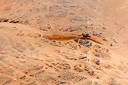
The Tsau ǁKhaeb (Sperrgebiet) National Park, formerly known as Sperrgebiet is a diamond mining area in southwestern Namibia, in the Namib Desert. It spans the Atlantic Ocean-facing the coast from Oranjemund on the border with South Africa, to around 72 kilometres (45 mi) north of Lüderitz, a distance of 320 km (200 mi) north. It extends to around 100 km (62 mi) inland, and its total area of 26,000 km2 (10,000 sq mi), makes up three percent of Namibia's land mass. However, mining only takes place in five percent of the Sperrgebiet, with most of the area acting as a buffer zone. Members of the public are banned from entering most of the area, despite the creation of a national park there in 2004.

Lüderitz railway station is a railway station serving the town of Lüderitz in Namibia. It was erected in 1904.

Grasplatz is a defunct railway station in the south of Namibia on the currently decommissioned Aus–Lüderitz line. It is the place where in 1908 railway worker Zacharias Lewala found the first diamond in German South-West Africa and handed it over to his foreman August Stauch. Stauch's subsequent investigation triggered a diamond rush.
August Stauch was a German prospector who discovered a diamond deposits near Lüderitz, in German South West Africa.
Zacharias Lewala was a Namibian worker, considered to have started a diamond rush in the area of Lüderitz in the former colony of German South West Africa, now Namibia, with his discovery of a diamond on 14 April 1908.

Dikwillem (Afrikaans) or Dicker Wilhelm (German), also known as Garub-Berg or Garubberg, is a mountain in Namibia. With an elevation of 1496 meters and lying within the Namib desert, the mountain is visible from a great distance from all directions. It is about 15 kilometers north of the National Road B4 and about 80 kilometers east of Lüderitz.
Tsaus Mountains is a mountain range within Diamond Restricted Area also called Sperrgebiet located in the southwestern part of Namibia. It reaches a height of 1,107 m.

Aurus is a mountain at the eastern border of the Diamond Restricted Area also called Sperrgebiet, in the southwestern part of Namibia. It reaches a height of 1,050 m. Its expansion is about 5 km × 4 km.

The Klinghardt Mountains are a Namibian mountain range in the Diamond Restricted Area, also called Sperrgebiet. The Klinghardt Mountains are located approximately 90 km south-southeast of Lüderitz and extend over an area of about 350 km2. East of the Klinghardt Mountains is the mountain Höchster.

Höchster is a mountain in the Diamond Restricted Aerea, also called Sperrgebiet, in the southwestern part of Namibia. It reaches a height of 1,070 m. Its expansion is about 5 km × 4 km.

Heioab is a mountain in the Diamond Restricted Aerea, also called Sperrgebiet, in the southwestern part of Namibia. It reaches a height of 1,090 m. Its extent is about 7 km × 10 km.