
The Province of Como is a province in the north of the Lombardy region of Italy and borders the Swiss cantons of Ticino and Grigioni to the North, the Italian provinces of Sondrio and Lecco to the East, the Province of Monza and Brianza to the south and the Province of Varese to the West. The city of Como is its capital — other large towns, with more than 10,000 inhabitants, include Cantù, Erba, Mariano Comense and Olgiate Comasco. Campione d'Italia also belongs to the province and is enclaved in the Swiss canton of Ticino.
The Shag River is located in Otago in the South Island of New Zealand. It rises in the Kakanui Range, flowing southeast for 50 kilometres (31 mi) before reaching the Pacific Ocean on the south side of Shag Point east of Palmerston. The Dunback Branch railway that operated from the 1880s to 1989 largely followed the route of the river from its junction with the Main South Line near Shag Point township to its terminus in Dunback.

The Maniototo Plain, usually simply known as The Maniototo, is an elevated inland region in Otago, New Zealand. The region roughly surrounds the upper reaches of the Taieri River and the Manuherikia River. It is bounded by the Kakanui Range to the north and the Rock and Pillar Range to the southeast. It has a harsh, dry climate, ranging from over 30 °C in mid-summer to -15 °C in mid-winter.

Hampden, a rural township in North Otago, New Zealand, lies close to the North Otago coast, 35 kilometres south of Oamaru and 80 kilometres north of the city of Dunedin, to both of which it is connected by State Highway 1.
Danseys Pass is a mountain pass located in the Kakanui Mountains, between Central Otago and North Otago, in the South Island of New Zealand.
Beaumont is a small town in inland Otago, in the South Island of New Zealand. It is located on the Clutha River six kilometres southeast of Raes Junction, between Roxburgh and Balclutha. Beaumont is connected to Milton and Roxburgh by State Highway 8.

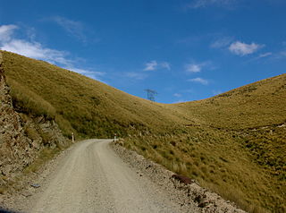
The Kakanui Range is a range of high hills located inland from Oamaru in the South Island of New Zealand. The range forms a boundary between the valley of the Waitaki River to the north and the high plateau known as the Maniototo and the upper watershed of the Taieri River to the southwest. The highest point in the Kakanui Range is Mount Pisgah, at 1643 m (5394 ft).
The lowland longjaw galaxias is a galaxiid of the genus Galaxias, found only in the South Island of New Zealand, in the Kauru River, a tributary of the Kakanui River in north Otago, and in parts of the upper Waitaki catchment. It grows to a length of up to 7 cm.
Weston is a township situated 5 km (3.1 mi) inland from Oamaru, South Island, New Zealand. It is regarded as one of the more affluent townships of the Waitaki District and had a population of 730 in the 2006 census.
Maheno is a small North Otago township south of Oamaru in New Zealand. The area has 75 residents. A number of the town's streets are named after places in Tyne and Wear, England, such as Whickham, Felling, Heworth and Jarrow.
The Otekaieke River is a river in New Zealand, a tributary of the Waitaki River.
The Sinclair River is a river of the Canterbury Region of New Zealand's South Island. It flows south from the Jollie Range and is one of the headwaters of the Clyde River, part of the upper Rangitata River system.

The Von River is a river in New Zealand, flowing into Lake Wakatipu. It was named after explorer Nicholas von Tunzelmann

The Waiho River is a river of the West Coast Region of New Zealand's South Island. It is fed by the meltwater of the Franz Josef Glacier and skirts the main township of Franz Josef to its south, where its river bed is crossed by SH6 on a long single-lane bridge. Due to changes in rainfall and snow melt, the river's water flow varies greatly. In a severe rain storm on 26 March 2019, the bridge was destroyed after 400 millimetres (16 in) of rain had fallen. The bridge and one abutment was rebuilt, and the road link reopened after 18 days. The works cost NZ$6m.
Kia Ora is a small dairy farming locality in North Otago, centred on Kia Ora Hall. It is located 10 kilometres west of Oamaru and a similar distance north of Maheno. The nearest watercourse is Robbs Crossing River, a small tributary of the Kakanui River.

The Wains Hotel Building is a historic hotel building in Dunedin, New Zealand.


