The Bear Island River is a river of Minnesota. The river flows through the southeast portion of Morse Township in northern Saint Louis County.
The Beaver River is a river of Minnesota. The river flows through the southwest part of Morse Township in northern Saint Louis County. It is a tributary of the Bear Island River.
The Beaver River is a 23.4-mile-long (37.7 km) river in Lake County, Minnesota. It flows into Lake Superior.
The Birch River (Minnesota) is a river of Minnesota.
The Burntside River is a river of Minnesota. The river flows through the west–central portion of Morse Township in northern Saint Louis County.

The Caribou River is a 15.0-mile-long (24.1 km) river in northern Minnesota, the United States. It rises in a swamp about .6 miles (1 km) south of Morris Lake and two miles (3.2 km) east of Echo Lake, near the Lake/Cook County line, at an altitude about 1620 feet above sea level. It descends some 1,020 feet in elevation as it flows south to its mouth at Lake Superior, also near the eastern border of Lake County.
The Dead River is a river of Minnesota. The river flows through the north–central part of Morse Township in northern Saint Louis County, and is a tributary of the Burntside River.
The Dunka River is a river of Minnesota.
The Greenwood River is a river of Minnesota. It is a tributary of the Stony River.
The Isabella River is a river of Minnesota.
The Island River is a river of Minnesota.
The Little Manitou River is a 1.8-mile-long (2.9 km) stream in Lake County, Minnesota. It flows directly into Lake Superior.
The Little Marais River is a river of Minnesota.
The Sand River is a river of Minnesota. It is a tributary of the Stony River.
The Shagawa River is a river of Minnesota. The river flows through the east–central part of Morse Township in northern Saint Louis County.
The Snake River is a river of Minnesota. It is a tributary of the Isabella River.
The South Kawishiwi River is a river of Minnesota.
The Stony River (Minnesota) is a river of Minnesota. It flows into the Rainy River.
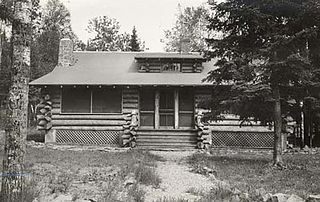
The Kawishiwi Field Laboratory, in Superior National Forest near Ely, Minnesota, usually known as K-Lab, hosted one of the longest running wolf population studies in the United States. It was designed by Forest Service architects following principles laid out by national Forest Service consulting architect W. Ellis Groben. It was built by the Civilian Conservation Corps in the 1930s. It served as the Halfway Ranger Station of the United States Forest Service until the 1960s and has since been used by other organizations, including the United States Geological Service and the International Wolf Center.
Stewart River is a stream in Lake County, in the U.S. state of Minnesota.

