
Ehime Prefecture is a prefecture of Japan located on the island of Shikoku. Ehime Prefecture has a population of 1,334,841 and has a geographic area of 5,676 km2. Ehime Prefecture borders Kagawa Prefecture to the northeast, Tokushima Prefecture to the east, and Kōchi Prefecture to the southeast.

Iyo is a city located in Ehime Prefecture, Japan. As of 31 March 2022, the city had an estimated population of 35,888 in 16169 households and a population density of 180 persons per km². The total area of the city is 194.44 square kilometres (75.07 sq mi).
Hōjō was a city located in Ehime Prefecture, Japan. The city was founded on November 1, 1958.
Onsen was a district located in Ehime Prefecture, Japan.
Masaki is a town located in Iyo District, Ehime Prefecture, Japan. As of 1 September 2022, the town had an estimated population of 30,411 in 13768 households and a population density of 1500 persons per km². The total area of the town is 20.41 square kilometres (7.88 sq mi). It is the smallest municipality in terms of area in Ehime Prefecture.

Tobe is a town located in Iyo District, Ehime Prefecture, Japan. As of 28 February 2022, the town had an estimated population of 20,485 in 9385 households and a population density of 200 persons per km2. The total area of the town is 101.59 square kilometres (39.22 sq mi).
Iyo is a district located in Ehime Prefecture, Japan. The district contains two towns: Masaki and Tobe. As of 2004 the estimated population is 52,832 with a total area of 121.89 km2.

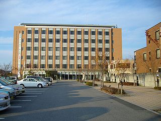
Tōon is a city located in Ehime Prefecture, Japan. As of 1 September 2022, the city had an estimated population of 33,276 in 15571 households and a population density of 160 persons per km². The total area of the city is 211.30 square kilometres (81.58 sq mi). The city name may be romanized as 'Toon', 'Tôon', 'Tōon' or 'Tohon'.
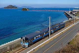
The Yosan Line is the principal railway line on the island of Shikoku in Japan, connecting the major cities of Shikoku, and via the Honshi-Bisan Line, with Honshu. It is operated by the Shikoku Railway Company, and is aligned approximately parallel with the Inland Sea coast, connecting the prefectural capitals of Takamatsu and Matsuyama and continuing on to Uwajima. The name of the line comes from Iyo (伊予) and Sanuki (讃岐), the old names of Ehime and Kagawa, respectively.
Matsuyama Station is a passenger railway station located in the city of Matsuyama, Ehime Prefecture, Japan. It is operated by JR Shikoku and has the station number "Y46".

Matsuyama is the capital city of Ehime Prefecture, on the island of Shikoku, in Japan and is also Shikoku's largest city. As of 1 October 2022, the city had an estimated population of 505,948 in 243,541 households and a population density of 1200 persons per km2. The total area of the city is 429.35 square kilometres (165.77 sq mi).
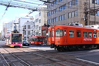
The Iyo Railway Co., Ltd. is the main transport provider in Matsuyama, Ehime, Shikoku, Japan. The company operates railway, tram, and bus lines, and also has many subsidiaries, which include a bank, department stores, travel agencies, and various other businesses.
Ukena District was a district located in central Iyo Province(Ehime Prefecture). Due to the 1878 Land Reforms, the district was separated into 2 districts written below.

Iyo-Matsuyama Domain was a feudal domain under the Tokugawa shogunate of Edo period Japan, in what is now central Ehime Prefecture on the island of Shikoku. It was centered around Matsuyama Castle, and was ruled throughout most of its history by the shinpan daimyō Hisamatsu-Matsudaira clan. Iyo-Matsuyama Domain was dissolved in the abolition of the han system in 1871 and is now part of Ehime Prefecture.

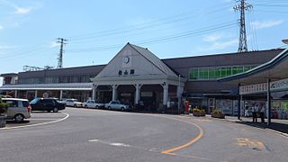
Iyo-Hōjō Station is a passenger railway station located in the city of Matsuyama, Ehime Prefecture, Japan. It is operated by JR Shikoku and has the station number "Y48".

Iyo Province was a province of Japan in the area of northwestern Shikoku. Iyo bordered on Sanuki Province to the northeast, Awa to the east, and Tosa to the south. Its abbreviated form name was Yoshū (予州). In terms of the Gokishichidō system, Iyo was one of the provinces of the Nankaidō circuit. Under the Engishiki classification system, Iyo was ranked as one of the "upper countries" (上国) in terms of importance, and one of the "far countries" (遠国) in terms of distance from the capital. The provincial capital was located in what is now the city of Imabari, but its exact location is still unknown. The ichinomiya of the province is the Ōyamazumi Shrine located on the island of Ōmishima in what is now part of Imabari. The people spoke Iyo dialect.

Yuzuki Castle was a former Japanese castle located in the city of Matsuyama, Ehime Prefecture, Japan. During the Muromachi period, it was the stronghold of the Kōno clan, who ruled Iyo Province under the Muromachi shogunate. The ruins of the castle were area designated a National Historic Site.

Matsuyama Castle , was a Sengoku period Japanese castle located in what is now part of the town of Yoshimi, Hiki District, Saitama, in the Kantō region of Japan. Its ruins have been protected as a National Historic Site, since 2008. It is also referred to as Musashi-Matsuyama Castle, to distinguish it from the more famous Bitchū Matsuyama Castle or Iyo Matsuyama Castle.