War and continuing fighting severely damaged Cambodia's transportation system — a system that had been inadequately developed in peacetime. The country's weak infrastructure hindered emergency relief efforts and created tremendous problems of procurement of supplies in general and of distribution. Cambodia received Soviet technical assistance and equipment to support the maintenance of the transportation network.
FUNCINPEC, National United Front for an Independent, Neutral, Peaceful and Cooperative Cambodia in English, is a royalist political party in Cambodia. Founded in 1981 by Norodom Sihanouk, it started off as a resistance movement against the People's Republic of Kampuchea (PRK) government. In 1982, it formed a resistance pact, the Coalition Government of Democratic Kampuchea (CGDK), together with the Khmer People's National Liberation Front (KPNLF) and the Khmer Rouge. It was one of the signatory parties of the 1991 Paris Peace Accords, which paved the way for the formation of the United Nations Transitional Authority in Cambodia (UNTAC). In 1992, FUNCINPEC became a political party and participated in the 1993 general elections organised by UNTAC. It won the elections, and formed a coalition government with the Cambodian People's Party (CPP), with which it jointly headed. Norodom Ranariddh, Sihanouk's son who had succeeded him as the party president, became First Prime Minister while Hun Sen, who was from the CPP, became Second Prime Minister.
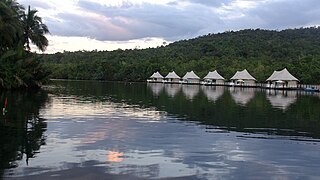
Koh Kong is a province (khaet) of Cambodia. The name means "Kŏng Island Province". Its capital is Khemarak Phoumin. The province was called Patchanta Khiri Khet from 1795 to 1904.

Kbal Spean is an Angkorian era archaeological site on the southwest slopes of the Kulen Hills to the northeast of Angkor in Siem Reap District, Siem Reap Province, Cambodia. It is situated along a 150m stretch of the Stung Kbal Spean River, 25 kilometres (16 mi) from the main Angkor group of monuments, which lie downstream.

Banteay Chhmar is a commune (khum) in Thma Puok District in Banteay Meanchey province in northwest Cambodia. It is located 63 km north of Sisophon and about 20 km east of the Thai border. The commune of Banteay Chhmar contains 14 villages.

Koh Rong, is the second largest island of Cambodia. The word Rong might refer to an old term for cave or tunnel, although some islanders say Rong refers to a historical person's name. It can also refer to the old Khmer word for shelter, adding up to Shelter Island.

Koh Russei,Koh Russey or Bamboo Island is one of a group of small islands in the Gulf of Thailand, located about 4.5 km (3 mi) off the coast of Sihanoukville city in southern Cambodia. It is administered by Prey Nob District in Sihanoukville Province.

Kampong Seila District is a district (srok) in south-western Cambodia, which formerly belonged to Koh Kong Province. In January 2009 King Norodom Sihamoni incorporated the district into Preah Sihanouk Province per Royal Decree, which states: "The administrative boundaries of Preah Sihanouk municipality and Koh Kong province shall be adjusted by sub-dividing land from Kampong Seila district in whole and partial land of Sre Ambil district in Koh Kong province to Preah Sihanouk municipality." Officials were assigned to create a National Workshop - also in relation to other provinces - and to process all necessary administrative tasks. The National Institute of Statistics of Cambodia refers in its most recent and preliminary studies to a successful integration of the district, including maps, although concluding statistics and numbers are expected to be available with the next full report. Preah Sihanouk Province's new official domain already runs administration of Kompong Seila district.
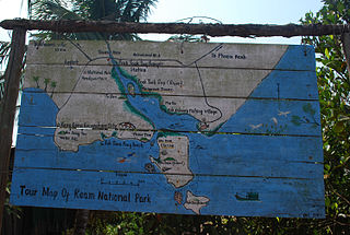
Ream National Park, its official name is Preah Sihanouk Ream National Park, is a national park of Cambodia located 18 km (11 mi) from Sihanoukville city in the Prey Nob district of the Sihanoukville Province in south-eastern Cambodia. It was established in 1993, as the Cambodian government began to take action for the protection of the country's threatened natural resources. The national park's biological value is defined by its combination of rivers, forests, mangroves, estuaries, beaches, coral reefs, wildlife, and marine life.

Kirirom National Park and officially recognized as Preah Suramarit-Kossamak Kirirom National Park is a national park in Cambodia. It is located mostly in Phnom Sruoch District, Kampong Speu Province, while a smaller section is in neighboring Koh Kong Province.

Phnom Kulen National Park and officially known as Preah Cheyvaraman-Norodom Phnom Kulen National Park is a National park in Cambodia. It is located in the Phnom Kulen mountain massif in Siem Reap Province. During Angkorian era the relief was known as Mahendraparvata and was the place where Jayavarman II had himself declared chakravartin, an act which is considered the foundation of Khmer Empire.
Sihanoukville Autonomous Port or Port Autonome de Sihanoukville (PAS) is a government agency and state corporation of Cambodia and Sihanoukville that operates and governs the country's sole deep water port. Located in Sihanoukville, in the Bay of Kompong Som at the Gulf of Thailand in south-western Cambodia. The port was inaugurated in 1960 as construction of the Old Jetty's four berths had begun in 1955.

Phnom Kulen, also romanized as is a mountain range and a part of Phnom Kulen National Park in Siem Reap Province, Cambodia.

Cambodia has 612 km (380 mi) of 1,000 mm metre gauge rail network, consisting of two lines originally constructed during the time when the country was part of French Indochina. Due to neglect and damage from civil war during the latter half of the 20th century, the railways were in a dilapidated state and all services had been suspended by 2009. As of 2016 freight and limited passenger service are available between Phnom Penh and Sihanoukville. Proposals to repair or replace the line from Phnom Penh to Battambang and the Thailand border are being discussed.

Preah Sihanouk Province, commonly referred to as Sihanoukville Province, is a province in the south-west of Cambodia at the Gulf of Thailand. The provincial capital, also called Sihanoukville, is a deep-water port city and a steadily growing and diversifying urban center located on an elevated peninsula.

Kep also romanized as Kaeb formally known as Kep Province (ខេត្តកែប) is the smallest province (khaet) of Cambodia covering 336 km2 (130 sq mi), with a population of 40,280. It is one of the newest Cambodian provinces, together with Pailin, Sihanoukville and Tboung Khmum, created by Royal Decree on 22 December 2008, which separated Kep Municipality & Damnak Chang'aeur District from the Kampot Province, as well as adjusting several provincial borders. It is both the smallest and least populous province of Cambodia. The provincial capital is Kep District and the province contains the Kep National Park.
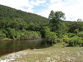
Koh Rong Sanloem is an island off the coast of Sihanoukville, Cambodia, 4 km (2 mi) south of Koh Rong island. It is around 9 km (6 mi) long, 4 km (2 mi) wide and 1 km (1 mi) wide at its narrowest point. Its distance from the local port of Sihanoukville is 25 km (16 mi) (beeline) and 23 km (14 mi) (beeline) from the Serendipity/Ochheuteal beach pier. The word "Sanloem" translates to: 1. drowsiness and to: 2. far out and hard to discern, in a wider sense. Inconsistencies on how to spell the island's name in its Latinized version date back to the 19th century. The first controversial spelling variants were issued by map makers during French rule. Alternatives have since become widespread and are in common usage. Often confusion ensues as Google Maps offers the phonetically most consistent variant, whereas Google Search redirects to an alternative.

Koh Pring, (Khmer: កោះព្រីង, Jambul Island, Koh Prins is a Cambodian island in the gulf of Thailand, 64 km off the coastal city of Sihanoukville. Official sources provide no data of civilian communities on the "Outer Islands". Administration falls to the Cambodian navy, as the island lies within the national marine border in which it represents an isolated outpost.
Prasat Ta Krabey or Prasat Ta Krabei, in Khmer and also known as Prasat Ta Khwai, in Thai, is a disputed Khmer temple which was built during Angkor period, the golden age of Cambodian history. This 11th century religious site was constructed in order to dedicated to Hindu god Shiva and has become a tourist attraction site near Cambodian-Thai border in recent years.


