Kei'a

Last updated

Districts of Mangaia Mangaia english version.png
Districts of Mangaia

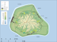
Kei'a (previously Te-apunavai) is one of the six traditional districts of the island of Mangaia, which is part of the Cook Islands archipelago. [1] [2] It is located on the west side of the island, to the south of the District of Tava'enga and west of Veitatei. The district was traditionally divided into 6 tapere : [1]

  1. Akaoro
  2. Tapuata
  3. Tongamarama
  4. Te-inati
  5. Rupetau-i-miri
  6. Rupetau-i-uta

The major habitation is the village of Oneroa, which is home to over half of the island's population. The Auraka cave is also in this district.

Related Research Articles

<span class="mw-page-title-main">Rongo</span> Māori god of cultivated plants

In Māori mythology, Rongo or Rongo-mā-Tāne is a major god (atua) of cultivated plants, especially kumara, a vital crop. Other crops cultivated by Māori in traditional times included taro, yams (uwhi), cordyline (), and gourds (hue). Because of their tropical origin, most of these crops were difficult to grow except in the far north of the North Island, hence the importance of Rongo in New Zealand.

<span class="mw-page-title-main">Rarotonga</span> Island of the Cook Islands

Rarotonga is the largest and most populous of the Cook Islands. The island is volcanic, with an area of 67.39 km2 (26.02 sq mi), and is home to almost 75% of the country's population, with 10,898 of a total population of 15,040. The Cook Islands' Parliament buildings and international airport are on Rarotonga. Rarotonga is a very popular tourist destination with many resorts, hotels and motels. The chief town, Avarua, on the north coast, is the capital of the Cook Islands.

In Polynesian mythology, Hawaiki is the original home of the Polynesians, before dispersal across Polynesia. It also features as the underworld in many Māori stories.

<span class="mw-page-title-main">Mangaia</span> Second largest of the Cook Islands

Mangaia is the most southerly of the Cook Islands and the second largest, after Rarotonga. It is a roughly circular island, with an area of 51.8 square kilometres (20.0 sq mi), 203 kilometres (126 mi) from Rarotonga. Originally heavily populated, Mangaia's population has dropped by 75% in the last 50 years, mainly due to the decline of the pineapple industry in the 1980s and a subsequent economic crisis in 1996.

<span class="mw-page-title-main">Atiu</span>

Ātiu, also known as ʻEnuamanu, is an island of the Cook Islands archipelago, lying in the central-southern Pacific Ocean. Part of the Nga-pu-Toru, it is 214 km (133 mi) northeast of Rarotonga. The population of the 26.9 square kilometres (10.4 sq mi) island has dropped by two-thirds in the last 50 years.

<span class="mw-page-title-main">Manuae (Cook Islands)</span> Atoll of the Cook Islands

Manuae is an uninhabited atoll in the southern group of the Cook Islands, 100 kilometres south-east of Aitutaki. Manuae is not administratively part of Aitutaki, however, it is part of Arutanga-Reureu-Nikaupara Constituency on Aitutaki for electoral purposes only.

Mangaia Airport is an airport on Mangaia in the Cook Islands. It lies 45 feet above mean sea level. In 2007, the airport received $5 million for development.

<span class="mw-page-title-main">Conquered lorikeet</span> Extinct species of bird

The conquered lorikeet is a species of parrot that became extinct 700–1300 years ago. It lived in islands of Polynesia. David Steadman and Marie Zarriello wrote its species description in 1987.

<span class="mw-page-title-main">Cook Islands Federation</span> British colony (1891–1901)

The Cook Islands Federation was created in 1891, after the Kingdom of Rarotonga was given the island of Aitutaki. It lasted until 1901, when it was given to New Zealand.

A Tapere or Sub-District is a low level of traditional land subdivision on five of the Southern Cook Islands, comparable to the ahupua'a of the main Hawaiian Islands or to the kousapw of Pohnpei. Among the populated raised islands, only Mitiaro is not subdivided into tapere. The remaining Southern Cook Islands, Manuae, Palmerston and Takutea are atolls and/or uninhabited, and therefore not subject to this type of traditional subdivision. The atolls of the Northern Cook Islands are subdivided into motu, instead.

<span class="mw-page-title-main">Karanga (district)</span>

Karanga is the smallest of the six traditional districts of the island of Mangaia, in the Cook Islands archipelago. Karanga is located in the northeast of the island, to the east of the District of Tava'enga and northwest of the District of Ivirua. The district was traditionally divided into 5 tapere:

  1. Kaau-i-uta
  2. Kaau-i-miri
  3. Teia-pini
  4. Teia-poto
  5. Teia-roa
<span class="mw-page-title-main">Veitatei</span>

Veitatei is one of the six traditional districts of the island of Mangaia in the Cook Islands. It is located in the south of the island, to the east of the District of Kei'a and west of the District of Tamarua. The district was traditionally divided into 6 tapere:

  1. Te-noki
  2. Te-tuaroa (Te-tukono)
  3. Te-tuapoto
  4. Te-tarapiki
  5. Kaikatu
  6. Angarino
<span class="mw-page-title-main">Tamarua</span>

Tamarua is one of the six traditional districts of the island of Mangaia, which is part of the Cook Islands archipelago. Tamarua is located in the southeast of Mangaia, to the south of the District of Ivirua and east of the District of Veitatei. The district was traditionally divided into 9 tapere:

  1. Maru-kore
  2. Poutoa-i-uta
  3. Poutoa-i-miri
  4. Akaea
  5. Te-vai-kao
  6. Angauru (Autaki)
  7. Vaitangi (Pukuotoi)
  8. Te-vai-taeta-i-uta
  9. Te-vai-taeta-i-tai
<span class="mw-page-title-main">Ivirua</span>

Ivirua is one of the six traditional districts of the island of Mangaia in the Cook Islands in the South Pacific Ocean. It is located in the east of the island, to the southeast of the District of Karanga and north of the District of Tamarua. The district was traditionally divided into 6 tapere:

  1. Te-pauru-o-Rongo
  2. Te-korokoro
  3. Te-uturei
  4. Te-ara-nui-o-Toi
  5. Te-i'i-maru
  6. Avarari
<span class="mw-page-title-main">Tavaʻenga</span>

Tava'enga is one of the six traditional districts of the island of Mangaia in the Cook Islands, in the South Pacific Ocean. It is located in the north of the island, to the west of the District of Karanga and east of the District of Kei'a. The district was traditionally divided into 6 tapere:

  1. Te-pueu
  2. Te-mati-o-Pa'eru
  3. Au-ruia
  4. Maro
  5. Te-rupe
  6. Ta'iti

Oneroa is the largest village on Mangaia island, which is part of the Cook Islands archipelago. It is located in the west of the island, in the district of Kei'a, and contains over half of the island's population. Oneroa is a contiguous village area that consists of three villages, Tavaʻenga, Kaumata and Temakatea.

Akava'ine is a Cook Islands Māori word which has come, since the 2000s, to refer to transgender people of Māori descent from the Cook Islands.

The Te Ipukarea Society (TIS) is an environmental non-government organisation based in the Cook Islands of Polynesia in the south-western Pacific Ocean. The original name was Taporoporo'anga Ipukarea Society, but was shortened a number of years ago to make it easier to pronounce. An approximate translation of the name from Cook Islands Māori is "looking after our heritage". It is the BirdLife International partner organisation for the Cook Islands, and also a member of the International Union for Conservation of Nature.

<span class="mw-page-title-main">Pokerekere Islet</span> Islet in the Cook Islands

Pokerekere Islet, also known as Pokerere or Tautua, is an islet in Penrhyn Atoll (Tongareva) in the Cook Islands. It is located on the eastern edge of the atoll, between Kavea and Tuirai.

<i>Marumaru Atua</i>

Marumaru Atua is a reconstruction of a vaka moana, a double-hulled Polynesian voyaging canoe. It was built in 2009 by the Okeanos Foundation for the Sea. In 2014, it was gifted to the Cook Islands Voyaging Society. It is used to teach polynesian navigation.

References

  1. 1 2 Te Rangi Hiroa (1934). Mangaian Society. Honolulu: Bernice P. Bishop Museum. p. 126. Retrieved 9 August 2020 via NZETC.
  2. Allen, Bryant (1971). "Wet-Field Taro Terraces on Mangaia, Cook Islands". Journal of the Polynesian Society . 80 (3): 371–378. ISSN   0032-4000. JSTOR   20704790 via JSTOR.

21°55′S157°58′W / 21.917°S 157.967°W / -21.917; -157.967