
Dawson Springs is a home rule-class city in Hopkins and Caldwell counties in the U.S. state of Kentucky. The population was 2,764 at the 2010 census. It is the birthplace of former governor Steve L. Beshear.
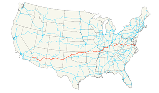
U.S. Route 60 (US 60) is an east–west United States highway, traveling 2,670 mi (4,300 km) from southwestern Arizona to the Atlantic coast in Virginia. Despite the final "0" in its number, indicating a transcontinental designation, the 1926 route formerly ended in Springfield, Missouri, at its intersection with the major US 66. In fact, US 66 was almost given the US 60 number.
U.S. Route 68 is a United States highway that runs for 560 miles (900 km) from northwest Ohio to Western Kentucky. The highway's western terminus is at US 62 in Reidland, Kentucky. Its present northern terminus is at Interstate 75 in Findlay, Ohio, though the route once extended as far north as Toledo. US 68 intersects with US 62 three times during its route. It is signed east–west in Kentucky and north–south in Ohio.

U.S. Route 460 is a spur of U.S. Route 60. It currently runs for 655 miles (1,054 km) from Norfolk, Virginia, at U.S. Route 60 at Ocean View to Frankfort, Kentucky, at U.S. Route 60. It passes through the states of Virginia, West Virginia, and to Frankfort, Kentucky, the state capital. It goes through the cities of Norfolk, Portsmouth, Suffolk, Petersburg, Farmville, Lynchburg, Roanoke, Blacksburg, Tazewell, and Grundy, in Virginia; Princeton and Bluefield in West Virginia; and Pikeville, and Frankfort, Kentucky.
Kentucky Route 70 (KY 70) is a long east-east state highway that originates at a junction with U.S. Route 60 (US 60) in Smithland in Livingston County, just east of the Ohio River. The route continues through the counties of Crittenden, Caldwell, Hopkins, Muhlenberg, Butler, Edmonson, Barren, Barren, Metcalfe, Green, Taylor, Casey, Pulaski, Lincoln and back into Pulaski again to terminate at a junction with US 150 near Maretburg in Rockcastle.
U.S. Route 41 in the state of Kentucky is a north-south United States Numbered Highway that mainly goes through the western part of the state. It enters Kentucky in the Todd County community of Guthrie, and leaves the state north of Henderson into Indiana as well as the city of Evansville. The total length of US 41 through Kentucky is a total of 106.952 miles (172.123 km).
U.S. Route 27 (US 27) in Kentucky runs 190.785 miles (307.039 km) from the Tennessee border to the Ohio border at Cincinnati. It crosses into the state in the Lake Cumberland area, passing near or through many small towns, including Somerset, Stanford, and Nicholasville. The road then passes straight through the heart of Lexington, including past the University of Kentucky (UK) and Transylvania University. North of Lexington it passes through Cynthiana and Falmouth before entering Campbell County and passing through many Northern Kentucky suburbs before ending at the Ohio state line on the Taylor Southgate Bridge in Cincinnati.
Eleven special routes of U.S. Route 62 currently exist. Six of them lie within the state of Arkansas. Four more existed in the past but have since been decommissioned.
U.S. Route 431 in Kentucky runs 86.465 miles (139.152 km) from the Tennessee state line south of Adairville to US 60 at Owensboro. It crosses the state in mainly west-central portions of the state, passing through or near towns such as Russellville, Lewisburg, Central City and Livermore. The route goes through Logan, Muhlenberg, McLean County, and Daviess Counties.
Kentucky Route 85 (KY 85) is a 33.150-mile-long (53.350 km) state highway in Kentucky that runs from Kentucky Route 70 west of Madisonville to U.S. Route 62 northeast of Rockport via Sacramento and Centertown.
Several special routes of U.S. Route 68 exist from Kentucky to Ohio. In order from west to east in Kentucky, and south to north in Ohio, these special routes are listed from the beginning of U.S. Route 68 to the end.
Kentucky Route 189 (KY 189) is a 32.027-mile-long (51.542 km) state highway in Kentucky that runs from Kentucky Route 507 and Flat Rock Road west of Allegre to U.S. Route 62 northeast of Powderly via Fearsville.
Kentucky Route 109 (KY 109) is an 89.6-mile-long (144.2 km) north–south state highway that traverses four counties in Kentucky's Pennyrile region. It traverses Christian, Hopkins, Webster, and Union counties.
Kentucky Route 224 (KY 224) is a 27.024-mile-long (43.491 km) state highway in Kentucky that runs from U.S. Route 62 and Vanmeter Street in Clarkson to Kentucky Route 357 west of Magnolia via Upton.
Kentucky Route 293 (KY 293) is a 38.267-mile-long (61.585 km) state highway in Kentucky that runs from Kentucky Routes 93 and 1055 southeast of Eddyville to Kentucky Route 270 northeast of Providence via Princeton and Providence.
Kentucky Route 262 (KY 262) is a 4.7-mile-long (7.6 km) state highway in the U.S. state of Kentucky. The highway connects rural areas of Hopkins with Madisonville.

