Dearborn County is one of 92 counties of the U.S. state of Indiana located on the Ohio border near the southeast corner of the state. It was formed in 1803 from a portion of Hamilton County, Ohio. In 2010, the population was 50,047. The county seat and largest city is Lawrenceburg.

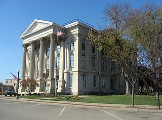
Lawrenceburg is a home rule-class city in Anderson County, Kentucky, United States. The population was 10,505 at the 2010 census. It is the seat of its county. Lawrenceburg is part of the Frankfort, Kentucky, micropolitan statistical area.
U.S. Route 42 is an east–west United States highway that runs southwest-northeast for 355 miles (571 km) from Louisville, Kentucky to Cleveland, Ohio. The route has several names including Pearl Road from Cleveland to Medina in Northeast Ohio, Reading Road in Cincinnati, Cincinnati and Lebanon Pike in southwestern Ohio and Brownsboro Road in Louisville. Traveling east, the highway ends in downtown Cleveland, Ohio; and traveling west it ends in Louisville.

The Flim-Flam Man is a 1967 American comedy film directed by Irvin Kershner, featuring George C. Scott, Michael Sarrazin, and Sue Lyon, based on the 1965 novel The Ballad of the Flim-Flam Man by Guy Owen. The movie has well-known character actors in supporting roles, including Jack Albertson, Slim Pickens, Strother Martin, Harry Morgan, and Albert Salmi.
The Martha Layne Collins Blue Grass Parkway is a controlled-access highway running from Elizabethtown, Kentucky to Woodford County, Kentucky, for a length of 71.134 miles (114.479 km). It intersects with Interstate 65 at its western terminus, and U.S. Route 60 at its eastern terminus. It is one of seven highways that are part of the Kentucky parkway system. The road is designated unsigned Kentucky Route 9002. It is constructed similar to the Interstate Highway system, though sections do not measure up to current Interstate standards.
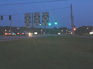
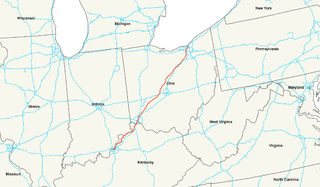
Kentucky Route 44 is a 70.193 mile (112.965 km) long state highway in the U.S. state of Kentucky managed and maintained by the Kentucky Transportation Cabinet.
The Anderson News is a weekly newspaper, founded in 1877, serving Lawrenceburg, Kentucky and the rest of Anderson County, Kentucky.

Glensboro is an unincorporated community in Anderson County, Kentucky, United States. It lies along Route 44 west of the city of Lawrenceburg, the county seat of Anderson County. Its elevation is 610 feet (186 m).

The Confederate Monument in Lawrenceburg, Kentucky is an 8-foot-tall (2.4 m) figure which was built in 1894 by the Kentucky Women's Monumental Association, a predecessor of the United Daughters of the Confederacy, an organization founded in that year. Its governing body is the government of Lawrenceburg.
U.S. Route 62 (US 62) in Kentucky runs for a total of 391.207 miles (629.587 km) across 20 counties in western, north-central, and northeastern Kentucky. It enters the state by crossing the Ohio River near Wickliffe, then begins heading eastward at Bardwell, and traversing several cities and towns across the state up to Maysville, where it crosses the Ohio River a second time to enter the state of Ohio.
Lawrenceburg Commercial Historic District may refer to:
Five special routes of U.S. Route 127 (US 127) exist in Kentucky. There are two business loops and three bypasses of US 127 in Kentucky. Additionally, there have been 10 different business routes of U.S. Route 127 in Michigan.
Kentucky Route 151 (KY 151) is a 7.811-mile-long (12.571 km) state highway in Kentucky. It runs from U.S. Route 127 (US 127) and US 127 Bypass northwest of Lawrenceburg to US 60 in rural Franklin County west of Frankfort.
Kentucky Route 390 (KY 390) is a 15.105-mile-long (24.309 km) state highway in the U.S. state of Kentucky. The highway connects mostly rural areas of Washington and Mercer counties with Harrodsburg.
Kentucky Route 420 (KY 420) is a 5.1-mile-long (8.2 km) state highway in the U.S. state of Kentucky. The highway connects southern parts of Franklin County with Frankfort.
