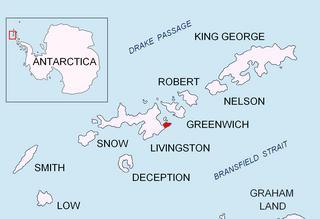
Kaloyan Nunatak is a conspicuous nunatak in the Tangra Mountains. It is named after Czar Kaloyan of Bulgaria, 1197-1207 AD.

Kotrag Nunatak is a conspicuous rocky peak of elevation 290 m projecting from Murgash Glacier, Greenwich Island in the South Shetland Islands, Antarctica. It was named after Khan Kotrag, founder of the Kingdom of Volga Bulgaria in the 7th Century AD.

Krum Rock is a small nunatak rising to 208 metres on the southwest edge of Balkan Snowfield just north of Contell Glacier on Hurd Peninsula in eastern Livingston Island, one of the South Shetland Islands in Western Antarctica. The rock projects slightly above the ice sheet with some 3,000 square metres of rocky ground exposed on its northern slope in summer. Because of its location rather than prominence, it is a particularly important landmark in the course of field work carried out in the area.

Mesta Peak is a conspicuous, sharp and narrow rocky peak extending 500 m in east-west direction and rising to approximately 400 m in Delchev Ridge, Tangra Mountains, eastern Livingston Island in the South Shetland Islands, Antarctica. The peak has steep and ice-free slopes and surmounts the east extremity of Sopot Ice Piedmont to the north.

Murgash Glacier is the 3.4 km long and 3.2 km wide glacier on Greenwich Island in the South Shetland Islands, Antarctica situated southeast of Yakoruda Glacier, south of Teteven Glacier, southwest of Traub Glacier and west-northwest of Bravo Glacier. It is bounded by Lloyd Hill on the northwest, Tile Ridge on the east and Hebrizelm Hill on the southeast, and drains southwards into Kramolin Cove in McFarlane Strait between Yovkov Point and Kaspichan Point.

Panagyurishte Nunatak is a rocky peak of elevation 150 m projecting from Yakoruda Glacier, Greenwich Island in the South Shetland Islands, Antarctica. The peak is named after the town of Panagyurishte in central Bulgaria.

Pautalia Glacier is a small glacier on Burgas Peninsula, Livingston Island in the South Shetland Islands, Antarctica situated northeast of Strandzha Glacier and south of Sopot Ice Piedmont. It is bounded by Petko Voyvoda Peak to the west, Sozopol Gap to the northwest, Kaloyan Nunatak to the north and Shabla Knoll to the east. The glacier extends 700 m in northwest-southeast direction and 1.1 km in southwest-northeast direction, and flows southeastward into Bransfield Strait.

Sliven Peak rises to 530 m in the east extremity of Melnik Ridge, Livingston Island in the South Shetland Islands, Antarctica. The peak has precipitous rocky southern slopes and partly ice-free northern slopes, overlooking Kaliakra Glacier to the northwest and Struma Glacier to the south and east.

Telerig Nunatak is a rocky peak of elevation 170 m projecting from the ice cap of Greenwich Island in the South Shetland Islands, Antarctica in the southwest extremity of Dryanovo Heights.

Willan Saddle is a flat, crescent-shaped and ice-covered saddle extending 1 km in the northeast-southwest direction between Burdick South Peak and Willan Nunatak in eastern Livingston Island in the South Shetland Islands, Antarctica. The saddle has an elevation of 400 m and is part of the overland route between Balkan Snowfield and Charrúa Gap in the west and Orpheus Gate in the east, thus providing access from the Bulgarian Base and the Spanish Base to the interior of eastern Livingston Island.

Balkan Snowfield is an ice-covered plateau of elevation ranging from 150 to 280 m in eastern Livingston Island in the South Shetland Islands, Antarctica, situated south of lower Perunika Glacier, northwest of Huntress Glacier and north of Contell Glacier. It is 3 km long in southwest-northeast direction and 2 km wide, and bounded by Burdick Ridge to the east, Willan Nunatak and Castillo Nunatak to the southeast, and Krum Rock to the southwest. The feature slopes gently northwestwards with its foot bounded by the hills along Bulgarian Beach. It is named after the Balkans.

Bogdan Ridge is a conspicuous rocky ridge of elevation 440 m forming the northeast extremity of Breznik Heights, Greenwich Island in the South Shetland Islands, Antarctica. The ridge extends 1.3 km westwards from Santa Cruz Point and surmounts Gruev Cove to the south.

Yovkov Point is a point on the southwest coast of Greenwich Island, Antarctica projecting 150 m southwards into McFarlane Strait, forming the northwest side of the entrance to Kramolin Cove. Formed as a result of Murgash Glacier's retreat in the late 20th and early 21st century. The feature is named after the famous Bulgarian writer Yordan Yovkov (1880–1937).

Willan Nunatak is an ice-free tipped peak rising to 449 m on the glacial divide between Huntress Glacier and Balkan Snowfield on Hurd Peninsula in eastern Livingston Island in the South Shetland Islands, Antarctica. It is linked to Burdick South Peak to the northeast by Willan Saddle and, via Castillo Nunatak and Charrúa Gap, to Charrúa Ridge to the west.

Lloyd Hill is an ice-covered hill rising to 335 m in the southwest of Dryanovo Heights, Greenwich Island in the South Shetland Islands, Antarctica. The hill surmounts Teteven Glacier to the north and Murgash Glacier to the southeast.

Bajo Nunatak is a conspicuous rocky peak rising to 210 m at the south edge of the ice cap of Robert Island in the South Shetland Islands, Antarctica. The nunatak surmounts Zahari Point to the southeast, Micalvi Cove to the east-southeast, and English Strait to the southwest.

López Nunatak is a steep-sided granitic nunatak, 275 metres (900 ft) high, forming the northern extremity of the Breznik Heights, Greenwich Island in the South Shetland Islands, Antarctica and overlooking Fuerza Aérea Glacier to the south-southwest, and Ash Point and the Chilean Captain Arturo Prat Base to the northwest.

Bagryana Point is the rounded ice-free tipped point on the southwest coast of Greenwich Island in Antarctica surmounted by Telerig Nunatak. It is named after the Bulgarian poet Elisaveta Bagryana (1893-1991).


