Kgomokasitwa

Last updated
Kgomokasitwa village
Botswana location map.svg
Red pog.svg
Kgomokasitwa village
Coordinates: 25°05′33″S25°37′17″E / 25.09250°S 25.62139°E / -25.09250; 25.62139

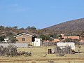
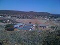
Kgomokasitwa is a small village in the Southern District of Botswana, [1] located some few kilometers north of Lobatse. To reach the village you travel by the A2 road between Lobatse and Kanye, then branch to the right at the Molapowabojang ward called Tshweneyagae. Kgomokasitwa has a population of about 1423 (2011 Census). [2] The village falls under the administration of the Southern District Council [1] which is headquartered in Kanye, Botswana. For civil administration it falls under Moshupa Sub District. [3]

Contents

History

Kgomokasitwa gets its name from a hill which is located 6 km from the village. Occasionally there can be seen mist at the top of the hill indicating that it may be cold up there, hence the name Kgomokasitwa or loosely translated, Freezing Cow. ( Kgomo = cow) and (sitwa = freezing). The majority of people in the village are of Bangwaketse tribe even though it is multi tribal.

Administration

The local councilor is Mr. Sonny Phiri [4] of Botswana Democratic Party. The village Chief or Headman of records is Mr. Sam Tshetlhe Radimpa [5] from May 2013.

Geography

Kgomokasitwa is located in hilly area. To the central east there is lentswe la Kgomokasitwa (Kgomokasitwa Hill); to the right east there are Mmadithakwe Hill and Mokgorana Hill. To the north there is Lentswe la diphala. There are seasonal rivers, Kwelepane River to the south and Chawe River to the north and far western parts of the village.

Education

Kgomokasitwa has one primary school for pupils aged from 5 year to 13 years. The pupils complete a 7-year curriculum which is finished by seating for PSLE( Primary School Leaving Examination) [6] Students then attend intermediate junior high in either Molapowabojang or Lobatse. For High school there is Lobatse Secondary School in Lobatse.

Health

Kgomokasitwa is serviced by Kgomokasitwa Health Post for primary care, and for hospital the community depends on Athlone Hospital in Lobatse. [7]

Developments

Transport

Accessible from Tshweneyagae Junction, [11] from A2- Lobatse- Windhoek highway or from B105 from Magotlhwane. B105 runs from Mogobane (By Otse Police College) to Ranaka.

Pictures

Related Research Articles

<span class="mw-page-title-main">Botswana</span> Country in Southern Africa

Botswana, officially the Republic of Botswana, is a landlocked country in Southern Africa. Botswana is topographically flat, with approximately 70 percent of its territory being the Kalahari Desert. It is bordered by South Africa to the south and southeast, Namibia to the west and north, Zambia to the north and Zimbabwe to the northeast. Being a country of slightly over 2.4 million people, and roughly the size of France, Botswana is one of the most sparsely populated countries in the world. It is essentially the nation state of the Tswana people, who make up 79% of the population.

<span class="mw-page-title-main">Gaborone</span> Capital and the largest city of Botswana

Gaborone is the capital and largest city of Botswana with a population of 246,325 based on the 2022 census, about 10% of the total population of Botswana. Its agglomeration is home to 421,907 inhabitants at the 2011 census. Gaborone has per capita income of US$32,000 (PPP), the highest in Africa.

Lobatse is a town in south-eastern Botswana, 70 kilometres south of the capital Gaborone, situated in a valley running north towards Gaborone and close to the border with South Africa. Lobatse has a population of 29,772 as of 2022. The town is an administrative district, with a town council.

<span class="mw-page-title-main">Kanye, Botswana</span> Village in Southern District, Botswana

Kanye is a village in southern Botswana, located 83 kilometres (52 mi) south-west of the capital, Gaborone. It is the administrative centre of the Southern District, and had a population of 48,028 as of the 2022 Population and Housing Census. This is an increase compared to the 45,196 of the 2011 census, making it the ninth-largest village in the country. Kanye is the traditional capital of the Ngwaketse tribe, who first settled in the area in the 1790s. The village is the longest continuously-occupied tribal capital in the country.

<span class="mw-page-title-main">Botswana Railways</span> National railway operator of Botswana

Botswana Railways (BR) is the national railway of Botswana.

The Internet in Botswana is used by approximately 87.2% of the population, as of 2023. There has been a massive increase in internet users since 2013 when only 30% of the population of Botswana was found to use the internet. This is notably higher than the percentage of internet users in Africa as a whole, which is around 43%. For reference, in 2023, the global statistic for internet users is 66%.

Otse is a village in the South-East District of Botswana. It is located 60 km south of Gaborone, along the Gaborone–Lobatse road and close to the border with South Africa. This village is home to the Balete people who are related to those in Ramotswa, Gabane and Mogobane. The population was 7,636 in 2011 census.

Tshepo Motlhabankwe is a former Motswana footballer who played for various Botswana Premier League teams such as Mochudi Centre Chiefs and Township Rollers as well as teams in the South African Premier Division. He is also a former Botswana international, having scored 2 goals between his debut in 2003 and retirement in 2013.

Botswana Telecommunications Authority (BTA) is a dissolved independent commission that was responsible for regulating all matters related to telecommunications, postal services of Botswana and has been succeeded by Botswana Communications Regulatory Authority. The Minister appoints all five board members, who serve on a part-time basis. The BTA is mandated to promote the development and provision of efficient telecommunications and broadcasting services in Botswana, under the terms of the Telecommunications Act 15 of 1996. There have been legal disputes between the BTA and licensed operators, springing from issues related to interconnection and pricing.

The Botswana National Broadcasting Board (NBB) was set up by the Broadcasting Act, 1998. The Board consists of eleven members who were appointed in August 2000. Section 10 of the Act, includes Board functions such as the issuing of broadcasting licences and the control and supervision of broadcasting activities, including the relaying of radio and television programmes from places in and out of Botswana to places in and outside Botswana.

Lejwana, Botswana is a small village in the Republic of Botswana in Africa. It is situated in the Southern District of Botswana. It lies between the coordinates 25°24'23S and 25°32'27E. It is situated between the villages of Gathwane, Pitsane, Kgoro, and Digawana. Lejwana is about 30 km from Lobatse and about 100 km by road from the capital Gaborone.

Molapowabojang is a village in the Southern District of Botswana, Located between Lobatse and Kanye, about 15 km North-West of Lobatse. With a population of about 7,520. This village falls under an administration of the Southern District Council which is headquartered in Kanye.

<span class="mw-page-title-main">Water Utilities Corporation</span> Government-owned corporation in Botswana

Water Utilities Corporation (WUC) is a government-owned corporation that provides water and waste water management services in Botswana. The Board is appointed by the Minister of Minerals, Energy and Water Resources. The water supply is critically important in the arid or semi-arid environment of Botswana.

The Bangwaketse are one of the eight principal tribes in Botswana, and are ethnic Tswana. Kanye is the original Bangwaketse village located in the Southern District settled in 1853, originally called Ntsweng Hill. The king of the tribe is King Malope II, son of Seepapitso IV. The Bangwaketse people live in the arid mountainous region of Southern Botswana mentioned in the book Cherub: Guardian Angel. It is bordered by Moshupa, Lobatse, and Jwaneng, and it is a 45-minute drive from Gaborone, the capital city of Botswana. The village is served by Kanye Airport.

The Botswana Prison Service (BPS) is the corrections agency of Botswana. It holds pre-trial and convicted prisoners.

<span class="mw-page-title-main">Gladys Olebile Masire</span>

Gladys Molefi Olebile Masire was a Botswana teacher and political figure who served as the longest ruling First Lady of Botswana from 1980 until 1998.

<span class="mw-page-title-main">Dumelang Saleshando</span>

Dumelang Saleshando is a politician from Botswana who served as the Leader of the Opposition in Botswana from 2019-2022. He was replaced by Dithapelo Keorapetse.

Lobatse Senior Secondary School is a government institution located in Lobatse, Botswana. It was established in the colonial era as a private school for whites but has been a public school since 1966 after independence. It received over 1000 students every year from different schools in the Southern District. It has boarding facilities which offer accommodation to students from far villages. Although it is known for doing well academically and in sports, it is also known as a school with undisciplined students. It was the only school in Botswana with over 10 security guards and students were monitored by the police during lunch to make sure there was no trouble in the dining hall. The school has a foundation named Lobatse Secondary school foundation that supports it by providing financial aid in the form of scholarships and grants in various areas including academic & non academic.

Matshelagabedi is a town in eastern Botswana, 17 kilometers from Francistown with a population of 3,488 in 2011: 1,706 males and 1,782 females. The town is hometown to retired middle-distance runner Glody Dube.

Thapelo Letsholo is a Botswana politician and entrepreneur. He is the current elected Member of Parliament for Kanye North constituency as of 2019. He is a member of the Botswana Democratic Party.

References

  1. 1 2 "Archived copy" (PDF). www.cso.gov.bw. Archived from the original (PDF) on 25 May 2013. Retrieved 15 January 2022.{{cite web}}: CS1 maint: archived copy as title (link)
  2. "Archived copy" (PDF). Archived from the original (PDF) on 2015-09-23. Retrieved 2016-11-13.{{cite web}}: CS1 maint: archived copy as title (link)
  3. "Republic of Botswana - Government portal". Gov.bw. Retrieved 2013-08-16.
  4. "Council Candidates 2009 General Elections_12.10.09 - Copy". Docstoc.com. 2009-11-09. Retrieved 2013-08-16.
  5. "Welcome to Daily News .:. General - Local - Radimpa ascends the throne". Dailynews.gov.bw. Retrieved 2013-08-16.
  6. "PSLE Exam Centres — BEC - Botswana Examinations Council". Bec.co.bw. Retrieved 2013-08-16.
  7. "Republic of Botswana - Government portal". Gov.bw. 2008-09-25. Retrieved 2013-08-16.
  8. "home". Bpc.bw. Archived from the original on 2013-08-06. Retrieved 2013-08-16.
  9. 1 2 https://web.archive.org/web/20130512092132/http://www.gov.bw/Global/MMWER/Media%20Releases/Standard%20cost%20villages.pdf. Archived from the original (PDF) on May 12, 2013. Retrieved July 23, 2013.{{cite web}}: Missing or empty |title= (help)
  10. "Welcome to WUC :: Home". Wuc.bw. Retrieved 2013-08-16.
  11. https://web.archive.org/web/20150226164702/http://www.gov.bw/PageFiles/8207/Parliament%20Office/ORD%20PAP%2021%2003%2013.pdf?epslanguage=en. Archived from the original (PDF) on February 26, 2015. Retrieved July 23, 2013.{{cite web}}: Missing or empty |title= (help)