
Sherpa is one of the ethnic groups native to the most mountainous regions of Nepal and the Himalayas. The term sherpa or sherwa derives from the Sherpa language words Shar ("east") and Wa ("people"), which refer to their geographical origin of eastern Nepal.

The Himalayan Trust is an international non-profit humanitarian organisation first established in the 1960s by Sir Edmund Hillary, who led the trust until his death in 2008. The Himalayan Trust aims to improve the health, education and general wellbeing of people living in the Solukhumbu District. The Himalayan Trust is headquartered in New Zealand where it is a registered charity through the Charities Commission. The Trust has charitable and donee status being a member of the Council for International Development (CID).

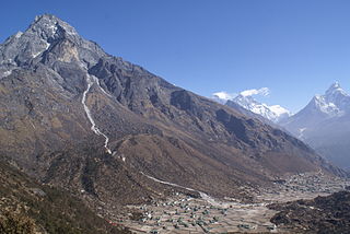
Namche Bazaar is a town and in Khumbu Pasanglhamu Rural Municipality in Solukhumbu District of Province No. 1 of north-eastern Nepal. It is located within the Khumbu area at 3,440 metres (11,286 ft) at its low point, populating the sides of a hill. Most Sherpa who are in the tourism business are from the Namche area. Namche is the main trading center and hub for the Khumbu region with many Nepalese officials, a police check, post, a bank, and even a beauty salon.
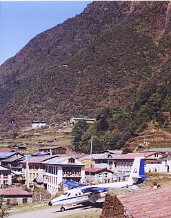
Lukla is a small town in the Khumbu Pasanglhamu rural municipality of the Solukhumbu District in the Province No. 1 of north-eastern Nepal. Situated at 2,860 metres (9,383 ft), it is a popular place for visitors to the Himalayas near Mount Everest to arrive. Although Lukla means place with many goats and sheep, few are found in the area nowadays.

Sagarmāthā was one of the fourteen zones of Nepal until the restructuring of zones into provinces. Sagarmāthā is a Nepali word derived from सगर् (sagar) meaning "sea" and माथा (māthā) meaning "head".
Khumjung is a village in Khumbu Pasanglhamu rural municipality of Solukhumbu District in Province No. 1 of north-eastern Nepal. It is located in the Khumbu subregion inside Sagarmatha National Park, a world heritage site. The village is at an elevation of 3,790 metres above sea level, and is situated near Mount Khumbila.

Khumbutse is the first mountain west (6 km) of Mount Everest. It lies at the border between Nepal and China.
The Hunku Glacier is located in the Khumbu of eastern Nepal and forms the southern base of Baruntse.
Solukhumbu District (Nepali: सोलुखुम्बु जिल्लाlisten , Sherpa: ཤར་ཁུམ་བུ་རྫོང་ཁ།, Kirat Rai language Wylie: shar khum bu dzong kha) is one of 14 districts of Province No. 1 of eastern Nepal. As the name suggests, it consists of the subregions Solu and Khumbu.

Thame and its neighbouring Thameteng are small Sherpa villages in Namche VDC of the Solukhumbu District in Nepal. These were the last year-round villages on the salt trading route that existed between Tibet, Nepal and India. It is the home to many famous Sherpa mountaineers, including Apa Sherpa, who held the world record for summiting Everest 21 times and Kami Rita Sherpa who has scaled the mountain 24 times as of May 2019. It was also a childhood home of Tenzing Norgay, who was one of the first men to climb Mt Everest. It is also where the famous Lama Zopa Rinpoche, the Lawudo Lama, head of the FPMT, was born. The Thame monastery is one of the oldest in the Khumbu region, and is famous for the annual Mani Rimdu festival.
Nawang Gombu was a Nepali-Indian mountaineer of Nepalese Sherpa origin.

Mahālangūr Himāl is a section of the Himalayas in northeast Nepal and south-central Tibet of China extending east from the pass Nangpa La between Rolwaling Himal and Cho Oyu, to the Arun River. It includes Mount Everest, Lhotse, Makalu, and Cho Oyu — four of Earth's six highest peaks. On the Tibetan side it is drained by the Rongbuk and Kangshung Glaciers and on the Nepali side by Barun, Ngojumba and Khumbu Glaciers and others. All are tributaries to the Koshi River via Arun River on the north and east or Dudh Kosi on the south.

Jubing was a village development committee in Solukhumbu District in the Sagarmatha Zone of north-eastern Nepal. It was divided and merged into two new formed Rural municipality in 2017 when the old administrative structures were reconstructed. Ward no. 2, 3, 4 and 6 were incorporated with Dudhkoshi rural municipality and remaining all wards 1, 5, 7, 8 and 9 were incorporated with Khumbu Pasanglhamu rural municipality.
The Imja Khola is a tributary of the Dudh Kosi in Nepal. It drains the slopes of Mount Everest. The Khumbu Glacier melts into the Lobujya (Lobuche) River, which flows southward as the Imja Khola to its confluence with the Dudh Kosi at Tengboche.

On 18 April 2014, seracs on the western spur of Mount Everest failed, resulting in an ice avalanche that killed sixteen climbing Sherpas in the Khumbu Icefall. This was the same icefall where the 1970 Mount Everest disaster had taken place. Thirteen bodies were recovered within two days, while the remaining three were never recovered due to the great danger of performing such an expedition. Many Sherpas were angered by what they saw as the Nepalese government's meager offer of compensation to victims' families, and threatened a protest or strike. On 22 April, the Sherpas announced they would not work on Everest for the remainder of 2014 as a mark of respect for the victims.

Lingtren, 6,749 metres (22,142 ft), is a mountain in the Mahalangur Himal area of Himalaya, about 8 kilometres (5.0 mi) distant in a direct line from Mount Everest. It lies on the international border between Nepal and the Tibet Autonomous Region of China and it was first climbed in 1935. A mountain nearby to the west was originally named Lingtrennup but is now more commonly called Xi Lingchain.
This page is based on this
Wikipedia article Text is available under the
CC BY-SA 4.0 license; additional terms may apply.
Images, videos and audio are available under their respective licenses.

