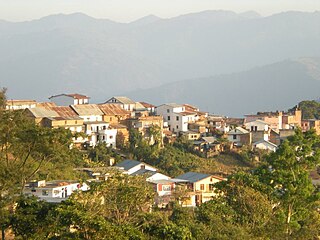
Dhankuta is a hill town and the headquarters of Dhankuta District in Koshi Province in Eastern Nepal. According to 2011 Nepal census, it has population of 26,440 inhabitants.

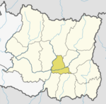
Dhankuta District is one of 14 districts of Koshi Province of eastern Nepal. The district covers an area of 891 km2 (344 sq mi) and has a population (2011) of 163,412. The hill town of Dhankuta serves as the district headquarters of Dhankuta District.

Panthar District is one of 14 districts of Koshi Province in the eastern hilly region of Nepal. It is a Hill district of eastern Nepal. The district covers 1,241 km2 (479 sq mi) of area. The 2011 census counted 191,817 population. Phidim is the district headquarters.
Ankhisalla is a village development committee in the Shahidbhumi Rural Municipality of Dhankuta District in the Province No. 1 of eastern Nepal. At the time of the 1991 Nepal census it had a population of 5220 people living in 923 individual households. The Chulung language is spoken in Ankhisalla.
Arkhaule Jitpur is a village development committee in Dhankuta District in the Kosi Zone of eastern Nepal. At the time of the 1991 Nepal census it had a population of 4691.
Belhara is a village development committee in Dhankuta District in the Province No. 1 of eastern Nepal. At the time of the 1991 Nepal census it had a population of 4857 people living in 874 individual households. The center part of it is called Guthitaar Bazzar. The main source of income of this area is tomato, capsicum and orange production.
Budhabare is a village development committee in Dhankuta District in the Koshi Zone of eastern Nepal. At the time of the 1991 Nepal census it had a population of 1954.
Chhintang is a village in Shahidbhumi Rural Municipality in the Dhankuta District of Province No. 1 in eastern Nepal. At the time of the 1991 Nepal census it had a population of 8071 people living in 1374 individual households. The Chintang language is primarily spoken in Chhintang.

Bhedetar is a village development committee in Dhankuta District in the Koshi Province of eastern Nepal. The main settlement began when the Dharan - Dhankuta Highway was completed in 1982. At the time of the 1991 Nepal census it had a population of 2643 people living in 513 individual households. It is 1,420 meters high from the sea level. It is actually on the border line of Sunsari and Dhankuta districts.
Danda Bazar is a village development committee in Dhankuta District in the Kosi Zone of eastern Nepal. At the time of the 1991 Nepal census it had a population of 2476 people living in 508 individual households.
Phaksib is a village development committee in Dhankuta District in the Kosi Zone of eastern Nepal. At the time of the 1991 Nepal census it had a population of 1827 people living in 350 individual households.
Phalate is a village development committee in Dhankuta District in the Kosi Zone of eastern Nepal. At the time of the 1991 Nepal census it had a population of 2656 people living in 501 individual households.
Jitpur Arkhaule is a village development committee in Dhankuta District in the Kosi Zone of eastern Nepal. At the time of the 1991 Nepal census it had a population of 4245 people living in 831 individual households.
Khoku is a village development committee in Shahidbhumi Rural Municipality in the Dhankuta District of Province No. 1 in eastern Nepal. At the time of the 1991 Nepal census it had a population of 3892 people living in 699 individual households.

Raja Rani is a village development committee in Dhankuta District in the Koshi Zone of eastern Nepal. At the time of the 1991 Nepal census it had a population of 2567 people living in 491 individual households.
Sangurigadhi is a rural municipality (gaunpalika) out of four rural municipality located in Dhankuta District of Koshi Province of Nepal. There are a total of 7 municipalities in Dhankuta in which 3 are urban and 4 are rural.
Chaubise is a rural municipality (gaunpalika) out of four rural municipality located in Dhankuta District of the Koshi Province of Nepal. There are a total of 7 municipalities in Dhankuta in which 3 are urban and 4 are rural.
Shahidbhumi is a rural municipality (gaunpalika) out of four rural municipality located in Dhankuta District of Koshi Province of Nepal. There are a total of 7 municipalities in Dhankuta in which 3 are urban and 4 are rural.
Chhathar Jorpati is a rural municipality (gaunpalika) out of four rural municipality located in Dhankuta District of Koshi Province of Nepal. There are a total of 7 municipalities in Dhankuta in which 3 are urban and 4 are rural.