Related Research Articles

Pemba Island is a Tanzanian island forming part of the Zanzibar Archipelago, lying within the Swahili Coast in the Indian Ocean.

Paxos is a Greek island in the Ionian Sea, lying just south of Corfu. As a group with the nearby island of Antipaxos and adjoining islets, it is also called by the plural form Paxi or Paxoi. The main town and the seat of the municipality is Gaios. The smallest of the seven main Ionian Islands, Paxos has an area of 25.3 square kilometres (9.8 sq mi), while the municipality has an area of 30.121 km2 (11.630 sq mi) and a population of about 2,500.

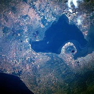
Lake Managua, also known as Lake Xolotlán, is a freshwater lake in Nicaragua. At 1,042 km², it is approximately 65 kilometres (40 mi) long and 25 kilometres (16 mi) wide. Similarly to the name of Lake Nicaragua, its other name comes from the Nahuatl language, possibly from the Spanish Tlaxcaltec and Mexica allies but most likely from the Nicarao tribes that had already settled in the region. The city of Managua, the capital of Nicaragua, lies on its southwestern shore.

Dakhlet Nouadhibou region is an administrative division of Mauritania. Its regional capital is Nouadhibou, which is located at its northwestern end and is home to nearly 95% of the region's population. The rest of the shoreline is sparsely populated with villages, but the east of the region is mostly uninhabited.

Mumbai Harbour, is a natural deep-water harbour in the southern portion of the Ulhas River estuary. The narrower, northern part of the estuary is called Thana Creek. The harbour opens to the Arabian Sea to the south. The historical island of Elephanta is one of the six islands that lie in the harbour.

Buckle Island is one of the three main islands in the uninhabited Balleny Islands group located in the Southern Ocean. It lies 25 km (16 mi) north-west of Sturge Island and 8 km (5 mi) south-east of Young Island, some 110 km (68 mi) north-north-east of Belousov Point on the Antarctic mainland. The island forms some parts of the Ross Dependency, claimed by New Zealand.

The Uru or Uros are an indigenous people of Bolivia and Peru. They live on a still-growing group of about 120 self-fashioned floating islands in Lake Titicaca near Puno. They form three main groups: the Uru-Chipaya, Uru-Murato, and Uru-Iruito. The Uru-Iruito still inhabit the Bolivian side of Lake Titicaca and the Desaguadero River.

The Cayos Arcas is a chain of three tiny sand cays and an accompanying reef system in the Gulf of Mexico, 128 kilometres from the mainland. It is located approximately 130 kilometres from the mainland, west of Campeche. Their aggregate land area is 22.8 hectares. They belong to the municipality of Campeche in the state of Campeche.

Masirah Island, also referred to as Mazeira Island or Wilāyat Maṣīrah, is an island off the east coast of mainland Oman in the Arabian Sea, and the largest island of the country.

Cheduba Island is an island in the Bay of Bengal close to Ramree Island and belongs to Myanmar, formerly Burma. It has a maximum length of 33 km (21 mi), with an area of approximately 523 km2 (202 sq mi)

Kerkennah Islands are a group of islands lying off the east coast of Tunisia in the Gulf of Gabès, at 34°42′N11°11′E. The Islands are low-lying, being no more than 13 metres above sea level. The main islands are Chergui and Gharbi. The archipelago has an area of 160 square kilometres (62 sq mi) and a population of 15,501 (2014).

Tidra is an offshore island 29 kilometres long and 8 km (5 mi) wide. It is the largest island off the shore of Banc d' Arguin, Mauritania and is home to a community of Imraguen fishing tribe. The island is part of the Banc d'Arguin National Park.
The Islets of Mauritius include circa 130 tiny islets and rocks scattered around the coast of Mauritius, Rodrigues, Agalega and St Brandon.

Stråholmen is an island in Kragerø Municipality in Telemark county, Norway. The 56-hectare (140-acre) island lies off the mainland coast approximately 2 kilometres (1.2 mi) to the northeast of the island of Jomfruland. Stråholmen is about 1.5 kilometres (0.93 mi) long and 1 kilometre (0.62 mi) wide at the widest. Stråholmen faces the Skagerrak seas to the east and provides shelter for the inner coastline. The name is Norwegian and literally translates to "The Islet of Straws".
Iouik, also spelled Iwik, is a coastal town in western Mauritania. Located in the Banc d'Arguin National Park within the Dakhlet Nouadhibou region, it sits on a small peninsula.
Bremer Island, or Dhambaliya in the local language is an island in the Arafura Sea, in the northwest of the Gulf of Carpentaria, 3.4 km off the northeast corner of Arnhem Land, Northern Territory, Australia.
The Rabbit Islands are a group of small uninhabited Turkish islands in the northern Aegean Sea. They are situated approximately 7 kilometres (4 mi) off the mainland coast of the Turkish province of Çanakkale, 10 kilometres (6 mi) north of the island of Tenedos (Bozcaada), and 13 kilometres (8 mi) south-west of the entrance of the straights of the Dardanelles. The largest islet of the group, called Tavşan adası or Rabbit Island proper, is some 2 kilometres (1 mi) long and 600 metres (1,969 ft) wide. To its south are three small rocky islets called Pırasa, Orak and Yılan.
Codrington Island is a small uninhabited island off the north-east coast of Antigua.
References
- ↑ Johnson, Alan; Cézilly, Frank (2007). The Greater Flamingo. T & AD Poyser, London. p. 235. ISBN 978-0-7136-6562-8.