
Bethel Census Area is a census area in the U.S. state of Alaska. As of the 2010 census, the population is 17,013. It is part of the unorganized borough and therefore has no borough seat. Its largest community is the city of Bethel, which is also the largest city in the unorganized borough.
Nome Census Area is a census area located in the U.S. state of Alaska, mostly overlapping with the Seward Peninsula. As of the 2010 census, the population was 9,492. It is part of the unorganized borough and therefore has no borough seat. Its largest community by far is the city of Nome.
Anoka County is the fourth-most-populous county in the U.S. state of Minnesota. As of the 2010 United States census, the population was 339,534. The county seat and namesake of the county is the City of Anoka, which is derived from the Dakota word anokatanhan meaning "on both sides," referring to its location on the banks of the Rum River. The largest city in the county is the City of Blaine, the thirteenth-largest city in Minnesota and the eighth-largest Twin Cities suburb.
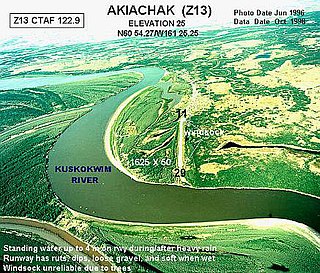
Akiachak (ACK-ee-uh-chuck) is a census-designated place (CDP) in the Bethel Census Area in the U.S. state of Alaska. The population was 627 at the 2010 census, up from 585 in 2000.

Akiak (ACK-ee-ack) is a city in Bethel Census Area, Alaska, United States. The population was 346 at the 2010 census, up from 309 in 2000.
Chefornak is a city in Bethel Census Area, Alaska, United States. At the 2010 census the population was 418, up from 394 in 2000.

Eek is a city in Bethel Census Area, Alaska, United States. At the 2010 census the population was 296.

Kasigluk is a census-designated place (CDP) in the Bethel Census Area in the U.S. state of Alaska. At the 2010 census the population was 569, up from 543 in 2000. Kasigluk consists of two smaller villages, called Akiuk and Akula.

Kipnuk is a census-designated place (CDP) in Bethel Census Area, Alaska, United States. At the 2010 census the population was 639, down from 644 in 2000.

Mekoryuk is a city located on Nunivak Island in the Bethel Census Area, Alaska, United States. At the 2010 census the population was 191, down from 210 in 2000.

Tununak(Tuen-unak) is a census-designated place (CDP) in Bethel Census Area, Alaska, United States. At the 2010 census the population was 327.

Bethel is a town in Sussex County, Delaware, United States. According to 2010 Census Bureau figures, the population of the town is 171. It is part of the Salisbury, Maryland-Delaware Metropolitan Statistical Area.

Dover is a town in Kingfisher County, Oklahoma, United States. The population 464 at the 2010 census. a 26.4 percent gain from 367 at the 2000 census.
Mount Hope is a town in Grant County, Wisconsin, United States. The population was 225 at the 2000 census. The Village of Mount Hope is located within the town. The unincorporated community of Shady Dell is also located in the town.

Necker Island is a small island in the Northwestern Hawaiian Islands. It is located at 23°34′30″N164°42′01″W in the Pacific Ocean, 155 miles northwest of Nihoa and 8 miles north of the Tropic of Cancer. It contains important prehistoric archaeological sites of the Hawaiian culture and is part of the Hawaiian Islands National Wildlife Refuge within the Northwestern Hawaiian Islands National Monument.

Hire Township is located in McDonough County, Illinois. As of the 2010 census, its population was 229 and it contained 117 housing units.

Hall Island is a small island located 3.5 miles (5.6 km) to the northwest of St. Matthew Island in the Bering Sea in Alaska, United States. It serves as a haulout site for Pacific walrus. It is 5 miles (8.0 km) in length and has a land area of 6.1758 square miles (15.995 km2). The highest point is 1,610 feet (490 m). Hall Island is uninhabited. It is part of the Bering Sea unit of the Alaska Maritime National Wildlife Refuge. It is one of three hall islands.
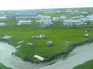
Umkumiute is a small unincorporated community on Nelson Island in the bay, 3 miles (4.8 km) from Toksook Bay. It is located in the Bethel Census Area.
Newtok Airport is a state-owned public-use airport located one nautical mile (1.85 km) west of the central business district of Newtok, a village in the Bethel Census Area of the U.S. state of Alaska. There is also a nearby seaplane landing area known as Newtok Seaplane Base, located at 60°55′25″N164°39′22″W on the Ninglick River.

Washington County, known locally as South County, is a county located in the U.S. state of Rhode Island. As of the 2010 census, the population was 126,979. Rhode Island counties have no governmental functions other than as court administrative and sheriff corrections boundaries, which are part of the state government.


