External links
| | This Mauritania location article is a stub. You can help Wikipedia by expanding it. |
Kiji is a small island off the coast of The Banc d'Arguin National Park, Mauritania. The island is uninhabited. Its area is 13,5 km2; its length is 7.8 km and its width is 2.2 km.
The isle is located west of the main island of Tidra; the smaller islet of Touffat lies to the south.
| | This Mauritania location article is a stub. You can help Wikipedia by expanding it. |

The Coral Sea Islands Territory is an external territory of Australia which comprises a group of small and mostly uninhabited tropical islands and reefs in the Coral Sea, north-east of Queensland, Australia. The only inhabited island is Willis Island. The territory covers 780,000 km2 (301,160 sq mi), most of which is ocean, extending east and south from the outer edge of the Great Barrier Reef and includes Heralds Beacon Island, Osprey Reef, the Willis Group and fifteen other reef/island groups. Cato Island is the highest point in the Territory.

The Dominican Republic is a country in the West Indies that occupies the eastern five-eighths of Hispaniola. It has an area of 48,670 km2, including offshore islands. The land border shared with Haiti, which occupies the western three-eighths of the island, is 376 km long. The maximum length, east to west, is 390 km from Punta de Agua to Las Lajas, on the border with Haiti. The maximum width, north to south, is 265 km from Cape Isabela to Cape Beata. The capital, Santo Domingo, is located on the south coast.

Madeira, officially the Autonomous Region of Madeira, is an autonomous region of Portugal. It is an archipelago situated in the North Atlantic Ocean, in the region of Macaronesia, just under 400 kilometres (250 mi) north of the Canary Islands —Spain—, 520 kilometres (320 mi) west of the Kingdom of Morocco and 805 kilometres (500 mi) southwest of mainland Portugal. Madeira sits on the African Tectonic Plate, although it is culturally, politically and ethnically associated with Europe, with its population predominantly descended from Portuguese settlers. Its population was 251,060 in 2021. The capital of Madeira is Funchal, on the main island's south coast.
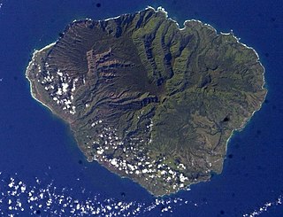
Kauaʻi, anglicized as Kauai, is one of the main Hawaiian Islands.

The Hawaiian Islands are an archipelago of eight major volcanic islands, several atolls, and numerous smaller islets in the North Pacific Ocean, extending some 1,500 miles from the island of Hawaiʻi in the south to northernmost Kure Atoll. Formerly called the Sandwich Islands by Europeans, the present name for the archipelago is derived from the name of its largest island, Hawaiʻi.

Mindoro is the seventh largest and eighth-most populous island in the Philippines. With a total land area of 10,571 km2, it has a population of 1,408,454, as of the 2020 census. It is located off the southwestern coast of Luzon and northeast of Palawan. Mindoro is divided into two provinces: Occidental Mindoro and Oriental Mindoro. Calapan is the only city in the island while San Jose is the largest settlement on the island with a total population of 143,430 inhabitants as of 2015. The southern coast of Mindoro forms the northeastern extremum of the Sulu Sea. Mount Halcon is the highest point on the island, standing at 8,484 feet (2,586 m) above sea level located in Oriental Mindoro. Mount Baco is the island's second highest mountain with an elevation of 8,163 feet (2,488 m), located in the province of Occidental Mindoro.

Boryeong, commonly known as Daecheon, is a city in South Chungcheong Province, South Korea. Boryeong is known around Korea for its beaches, particularly Daecheon Beach, and the annual Boryeong Mud Festival around July. The city's beach-mud is widely touted for its cosmetic properties. As elsewhere along the southwest coast of the Korean peninsula, there are numerous small islands, many of which are connected by ferry to Daecheon Port.

On 26 December 2004, at 07:58:53 local time (UTC+7), a major earthquake with a magnitude of 9.2–9.3 Mw struck with an epicentre off the west coast of Aceh in northern Sumatra, Indonesia. The undersea megathrust earthquake, known by the scientific community as the Sumatra–Andaman earthquake, was caused by a rupture along the fault between the Burma plate and the Indian plate, and reached a Mercalli intensity of IX in some areas.

Iceberg B-15 was the largest recorded iceberg by area. It measured around 295 by 37 kilometres, with a surface area of 11,000 square kilometres, about the size of the island of Jamaica. Calved from the Ross Ice Shelf of Antarctica in March 2000, Iceberg B-15 broke up into smaller icebergs, the largest of which was named Iceberg B-15-A. In 2003, B-15A drifted away from Ross Island into the Ross Sea and headed north, eventually breaking up into several smaller icebergs in October 2005. In 2018, a large piece of the original iceberg was steadily moving northward, located between the Falkland Islands and South Georgia Island. As of August 2023, the U.S. National Ice Center (USNIC) still lists one extant piece of B-15 that meets the minimum threshold for tracking. This iceberg, B-15AB, measures 20 km × 7 km ; it is currently grounded off the coast of Antarctica in the western sector of the Amery region.
Northeast Glacier is a steep, heavily crevassed glacier, 13 nautical miles long and 5 nautical miles wide at its mouth, which flows from McLeod Hill westward and then south-westwards into Marguerite Bay between the Debenham Islands and Roman Four Promontory, on the west coast of Graham Land, Antarctica.
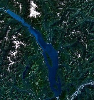
Harrison Lake is the largest lake in the southern Coast Mountains of Canada, being about 250 square kilometres (95 mi2) in area. It is about 60 km (37 mi) in length and at its widest almost 9 km (5.6 mi) across. Its southern end, at the resort community of Harrison Hot Springs, is c. 95 km east of downtown Vancouver. East of the lake are the Lillooet Ranges while to the west are the Douglas Ranges. The lake is the last of a series of large north–south glacial valleys tributary to the Fraser along its north bank east of Vancouver, British Columbia. The others to the west are the Chehalis, Stave, Alouette, Pitt, and Coquitlam Rivers. Harrison Lake is a natural lake, not man-made. The lake is supplied primarily from the Lillooet River, which flows into the lake at the northernmost point.

Salm Island is a roughly round-shaped island in Franz Josef Land, Arkhangelsk Oblast, Russia.
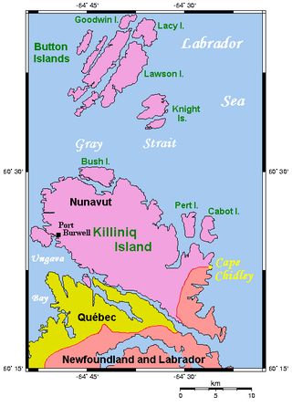
The Cape Chidley Islands are members of the Arctic Archipelago in the territory of Nunavut. They are located in the Labrador Sea at the south end of the entrance to the Hudson Strait, north of Killiniq Island's Cape Chidley, and separated from Killiniq Island by the MacGregor Strait.
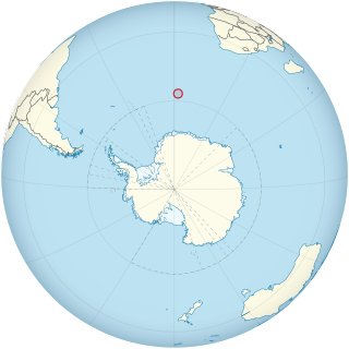
Bouvet Island is an uninhabited subantarctic volcanic island and dependency of Norway. It is a protected nature reserve, and situated in the South Atlantic Ocean at the southern end of the Mid-Atlantic Ridge, it is the world's most remote island. Located north of the Antarctic Circle, Bouvet Island is not part of the southern region covered by the Antarctic Treaty System.
The Strathcona Islands are uninhabited Canadian arctic islands located in Hudson Strait, Nunavut, Canada. They are a Baffin Island offshore island group in Qikiqtaaluk Region lying from 2 mi (3.2 km) to 9 mi (14 km) west of Cape Colmer. The group consists of a large island that rises in a series of rocky ridges to 183 m (600 ft); its south side is low and irregular. There are also several small, rocky islands.

The coastline of Brazil measures 7,491 km, making it the 16th longest national coastline in the world. The coastline touches exclusively the Atlantic Ocean. Brazil's coastline has many geographical features such as islands, reefs, bays, and its 2,095 beaches.
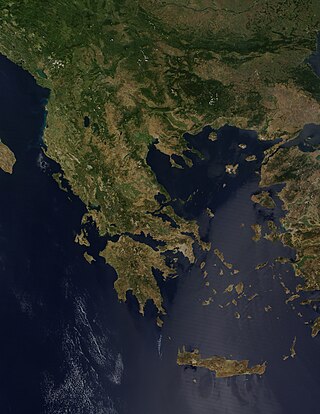
Greece is a country in Southeastern Europe, on the Balkan Peninsula. It is bordered to the north by Albania, North Macedonia and Bulgaria; to the east by Turkey, and is surrounded to the east by the Aegean Sea, to the south by the Cretan and the Libyan seas, and to the west by the Ionian Sea which separates Greece from Italy.
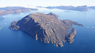
Inussulissuaq Island is a small uninhabited island in the Melville Bay region of the Upernavik Archipelago in Avannaata municipality in northwestern Greenland. The name of the island means "a large cairn" in the Greenlandic language.
Inussulik Bay is a bay in the Upernavik Archipelago in Avannaata municipality in northwestern Greenland.