
The County of Bute, also known as Buteshire, is a historic county and registration county of Scotland. Now replaced by Argyll and Bute for the Isle of Bute, with the Argyll and Bute Council. The Isle of Arran and the The Cumbraes are now in North Ayrshire Council area. Since the implimentation of the Local Government etc. (Scotland) Act 1994, on the 1 April 1996.

Kintyre is a peninsula in western Scotland, in the southwest of Argyll and Bute. The peninsula stretches about 30 miles, from the Mull of Kintyre in the south to East and West Loch Tarbert in the north. The region immediately north of Kintyre is known as Knapdale.
Sanda Island is a small island in the Firth of Clyde, off of Argyll and Bute, Scotland, near the southern tip of the Kintyre peninsula, near Southend and Dunaverty Castle.

Island Davaar or Davaar Island is located at the mouth of Campbeltown Loch off the east coast of Kintyre Peninsula, in Argyll and Bute, west of Scotland. It is a tidal island, linked to the mainland by a natural shingle causeway called the Doìrlinn near Campbeltown at low tide. The crossing can be made in around 40 minutes.
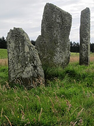
Ballochroy is a megalithic site in Kintyre on the Argyll peninsula in Scotland. It consists of three vertical stones, side by side, aligned with various land features 7–19 miles (11–31 km) away.

The North Channel is the strait between north-eastern Northern Ireland and south-western Scotland. The Firth of Clyde merges with the channel, between the southern tip of the Kintyre peninsula and Corsewall Point on the Rhins of Galloway. The channel begins north of the Isle of Man and is customarily considered part of the Irish Sea, the channel runs north-west into the Atlantic Ocean.

Achinhoan is a settlement on the Kintyre Peninsula in Argyll and Bute, west of Scotland. It consists of a handful of buildings, half a mile (one km) west of Achinhoan Head and three miles (five km) southeast of Campbeltown.

Claonaig is a hamlet on the east coast of the Kintyre peninsula in western Scotland, linked to Lochranza on the Isle of Arran by the CalMac ferry MV Catriona in the summer months.
Torrisdale is a small village on the eastern coast of the Kintyre Peninsula of Scotland. The village is along Torrisdale Bay, an inlet of the Kilbrannan Sound. It is the location of Torrisdale Castle, a 19th-century castle that is now a tourist destination.

Saddell Abbey is a ruined Cistercian monastery located in western Scotland. The abbey was established in 1160 by Somerled, Lord of Kintyre, who was killed in 1164. The abbey was completed by his son, Ragnall, a few years later. The original layout of the abbey included a church and three adjoining buildings grouped around a cloister. Saddell Abbey is widely known for its important collection of life-sized stone carvings and burial slabs that were constructed from the 14th to the 16th centuries. Historic Environment Scotland established the site as a scheduled monument in 1975.

Airds Castle is a ruined medieval castle near Carradale, Kintyre, Argyll and Bute, Scotland. The castle held a position on the summit of a rocky headland between Carradale harbour and the bay of Port Righ, looking across Kilbrannan Sound to the Isle of Arran.

Torr Mor is a hill peak landform on the coastal east side of the Kintyre Peninsula in Scotland. The peak offers views over the Kilbrannan Sound. The Forestry Commission maintain a footpath over the hill.

Eilean Ceann na Creige is a small island near Kennacraig in West Loch Tarbert in Scotland. Ceann na Creige is Gaelic for head of the rock.

Dippen Bay is an embayment along Kilbrannan Sound on the east coast of the Kintyre Peninsula in Scotland. Coastal erosion has been documented at Dippen Bay as well as nearby Torrisdale Bay. The bay is located along the coast near the hamlet of Dippen.
Dippen is a hamlet on the east coast of the Kintyre Peninsula in Scotland. The community of Dippen is in close proximity to Dippen Bay. Roads on the east coast of Kintyre were greatly improved in the era circa 1776, when the settlement was known as Duppin.

Torrisdale Bay is a coastal embayment along the east side of the Kintyre Peninsula within Kilbrannan Sound in Scotland. The shoreline of the bay consists partially of a shingle beach. Nearby is located Torrisdale Castle. The villages of Torrisdale and Bridgend lie along Torrisdale Bay with Carradale directly to the north. Bottlenose dolphins and harbor porpoises are often sighted.

Muasdale is a hamlet on the western coast of the Kintyre Peninsula of Scotland. As of the year 2000 Muasdale had a population of 300. By the year 1750 the Roy map showed a coastal track along the west coast of Kintyre, even though the population level of the entire southern peninsula was very low.
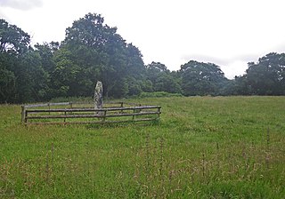
The Avinagillan standing stone is a prehistoric menhir on the Kintyre Peninsula of Scotland. The stone is near the hamlet of Avinagillan.
Saddell Bay is an embayment along the eastern side of the Kintyre Peninsula of Scotland. Saddell Bay is an element of Kilbrannan Sound that separates the Kintyre Peninsula from the Isle of Arran. Other bays along the east side of the Kintyre Peninsula include Kildonald Bay and Dippen Bay.

The Campbeltown Heritage Centre is a museum and heritage centre in Campbeltown, Argyll, Scotland. The centre is the main repository for social history for the Kintyre Peninsula from around 1700 to the present day, and is run by the Kintyre Amenity Trust.
