Related Research Articles

Kilkenny West, previously Maherquirke or Dillons country, is a barony in west County Westmeath, Ireland. It was formed by 1542. It is bordered by County Longford to the west; it is also bordered by three other Westmeath baronies: Rathconrath, Brawny and Clonlonan. The largest centre of population in the barony is the village of Glassan.
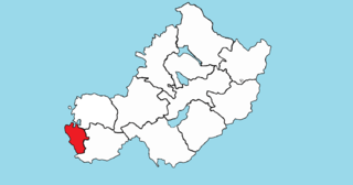
Brawny is a barony in south–west County Westmeath, Ireland. It was formed by 1672. It is bordered by County Roscommon to the west. It also borders two other Westmeath baronies: Kilkenny West and Clonlonan. The largest centre of population in the barony is the town of Athlone.
St. Marys is a civil parish in County Westmeath, Ireland. It is located about 38.96 kilometres (24 mi) west–south–west of Mullingar.
Dalystown is a village in Carrick, County Westmeath, Ireland. It is located in the south of the county on the N52 road, to the north of Tyrrellspass and Rochfortbridge.
Drumman, also known as Drummond is a townland in Milltownpass in County Westmeath, Ireland. The townland is in the civil parish of Pass of Kilbride and is on the border with County Offaly. The M6 Motorway cuts through the middle of the townland, and the R446 regional road forms the northern border with the townlands of Milltown and Corcloon. The village of Milltownpass is located to the east of the townland, with Rochfortbridge to the west.
Oldtown is a townland in County Westmeath, Ireland. The townland is approximately 1.4 square kilometres (0.5 sq mi) in area, and located near the border with County Offaly in the civil parish of Castlelost. The M6 Motorway runs to the south near the junction linking up with the R400 regional road. The R446 regional road cuts through the middle of the townland. The town of Rochfortbridge is to the east. As of the 2011 census, the townland had a population of 25 people in 9 homes.
Beggstown is a small townland in County Westmeath, Ireland. The townland is located in the civil parish of Kilbride. The R400 regional road runs through the middle of the area. The townland is to the south of Mullingar, and the north of Rochfortbridge.
Athlone is the name given to two bordering townlands in County Westmeath, Ireland. The townlands are in the civil parish of St. Mary's.
Curragh (Mechum) is a townland in Athlone, County Westmeath, Ireland. The townland is in the civil parish of St. Mary's.
Goldenisland is a small townland in Athlone, County Westmeath, Ireland. The townland, which is 0.04 square kilometres (0.02 sq mi) in area, is in the civil parish of St. Mary's. The townland is located to the south of the town, and is bordered by Goldenisland (Kilmaine) to the west and south and by the townland of Athlone to the north.
Killmacuagh (Castlemaine) is a townland in Athlone, County Westmeath, Ireland. The townland is in the civil parish of St. Mary's.
Killmacuagh (Cooke) is a townland in Athlone, County Westmeath, Ireland. The townland is in the civil parish of St. Mary's.
Kilnafaddoge is a small townland in Athlone, County Westmeath, Ireland. The townland, which is 0.12 square kilometres (0.05 sq mi) in area, is in the civil parish of St. Mary's. As of the 2011 census, Kilnafaddoge contained no occupied houses and zero population.
Loughanaskin is a townland in Athlone, County Westmeath, Ireland. The townland is in the civil parish of St. Mary's.
Loughandonning is a townland in Athlone, County Westmeath, Ireland. The townland is in the civil parish of St. Mary's.

Moydrum is a townland near Athlone, County Westmeath, Ireland. The townland is in the civil parishs of St. Mary's and Ballyloughloe (Clonlonan).
Retreat is a townland in Athlone, County Westmeath, Ireland. The townland is in the civil parish of St. Mary's.
Warrensfields is a townland in Athlone, County Westmeath, Ireland. The townland is in the civil parish of St. Mary's.
Robinstown (Tyrrell) is a townland in Mullingar civil parish in County Westmeath, Ireland. The townland, which is 0.39 square miles (1.0 km2) in area, had no recorded population as of the 2011 census. It is named for the Tyrrell baronets.
Ardmore is a small townland in Mullingar in County Westmeath, Ireland. The townland is approximately 0.2 square miles (0.5 km2) in area and located in Mullingar civil parish. A section of the N52 road passes through the area, and the Royal Canal passes to the southeast of the townland. No population was recorded for the townland in the 2011 census.
References
- ↑ "Kilmacuagh (Mechum) Townland, Co. Westmeath". www.townlands.ie. Retrieved 5 June 2020.
- ↑ "Cill Mhic Dhuach/Kilmacuagh (Mechum)". Logainm.ie. Retrieved 5 June 2020.
- ↑ "Griffith's Valuation". www.askaboutireland.ie. Retrieved 5 June 2020.
- ↑ "Relation: Kilmacuagh (Mechum) (4185075)". OpenStreetMap. Retrieved 5 June 2020.
| | This article related to the geography of County Westmeath, Ireland is a stub. You can help Wikipedia by expanding it. |