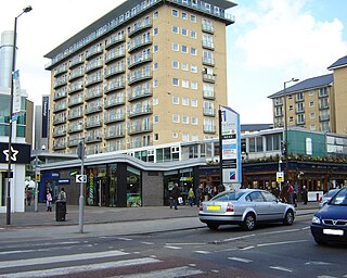
Feltham is a town in West London, England, 13 miles (21 km) from Charing Cross. Historically part of Middlesex, it became part of the London Borough of Hounslow in 1965. The parliamentary constituency of Feltham and Heston has been held by Labour Party MPs since 1992. In 2011, the population of the combined census area of Feltham, Bedfont and Hanworth was 63,368.

King's Cross is a district in the London Boroughs of Camden and Islington, on either side of Euston Road in north London, England, 1.5 miles (2.4 km) north of Charing Cross, bordered by Barnsbury to the north, Clerkenwell to the southeast, Angel to the east, Holborn and Bloomsbury to the south, Euston to the west and Camden Town to the northwest. It is served by two major rail termini, St Pancras and King's Cross. King's Cross station is the terminus of one of the major rail routes between London and the North.

Regent Street is a major shopping street in the West End of London. It is named after George, the Prince Regent and was laid out under the direction of the architect John Nash and James Burton. It runs from Waterloo Place in St James's at the southern end, through Piccadilly Circus and Oxford Circus, to All Souls Church. From there Langham Place and Portland Place continue the route to Regent's Park.

Oxford Street is a major road in the City of Westminster in the West End of London, running between Tottenham Court Road and Marble Arch. It marks the notional boundary between the areas of Fitzrovia and Marylebone to the north, with Soho and Mayfair to its immediate south. It is Europe's busiest shopping street, with around half a million daily visitors, and as of 2012 had approximately 300 shops. It is designated as part of the A40, a major road between London and Fishguard, though it is not signed as such, and traffic is regularly restricted to buses and taxis.

Euston Road is a road in Central London that runs from Marylebone Road to King's Cross. The route is part of the London Inner Ring Road and forms part of the London congestion charge zone boundary. It is named after Euston Hall, the family seat of the Dukes of Grafton, who had become major property owners in the area during the mid-19th century.

Great Crosby is an area of the town of Crosby, in the Metropolitan Borough of Sefton, Merseyside, England and is historically, part of Lancashire.

The Strand is a major street in the City of Westminster, Central London. The street, which is part of London's West End theatreland, runs just over 3⁄4 mile (1.2 km) from Trafalgar Square eastwards to Temple Bar, where it becomes Fleet Street in the City of London, and is part of the A4, a main road running west from inner London.

Kilmarnock is a town and former burgh in East Ayrshire situated in southwest Scotland. The town has served as the administrative centre of East Ayrshire Council since 1996 and is the region's main commercial and industrial centre. The town has a total of 284 listed buildings and structures as designed by Historic Environment Scotland, including the Dick Institute, Dean Castle, Loanhead School and the original 1898 building of Kilmarnock Academy, with post–war developments of the controversial 1970s regeneration such as The Foregate and Clydesdale Bank building being considered for listed building status.
Princes Street is one of the major thoroughfares in central Edinburgh, Scotland and the main shopping street in the capital. It is the southernmost street of Edinburgh's New Town, stretching around 1.2 km from Lothian Road in the west, to Leith Street in the east. The street has few buildings on the south side and looks over Princes Street Gardens allowing panoramic views of the Old Town, Edinburgh Castle, as well as the valley between. Most of the street is limited to trams, buses and taxis with only the east end open to all traffic.

Leicester City Centre is Leicester's historical commercial, cultural and transport hub and is home to its central business district. Its inner core is roughly delineated by the A594, Leicester's inner ring road, although the various central campuses of the University of Leicester, De Montfort University and Leicester College are adjacent to the inner ring road and could be considered to be a continuation of the City centre. In a similar way, the Leicester Royal Infirmary precinct, New Walk business district (Southfields), the Welford Road Stadium of Leicester Tigers’ RUFC and the King Power Stadium of Leicester City to the south, and the Golden Mile to the north could also be deemed to be extensions to the central core.

The Headrow is an avenue in Leeds city centre, West Yorkshire, England.
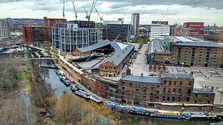
King's Cross Central (KXC) is a mixed-use development in the north-east of central London. The site is owned and controlled by the King's Cross Central Limited Partnership. It consists of approximately 67 acres (27 ha) of former railway lands to the north of King's Cross and St Pancras mainline railway stations. The site is largely determined by three boundaries: the existing East Coast Main Line railway leading out of King's Cross; York Way, a road marking the division between Camden and Islington boroughs; and the new railway line, High Speed 1 (HS1), formerly known as the Channel Tunnel Rail Link, which curves around the site to the north and west.
Trabboch is a hamlet in East Ayrshire, Scotland. Built as a miners village in the 1880s, it was owned and leased by Wm. Baird & Co., Ltd. and at one time had 94 dwellings. The miners rows stood, until demolition in 1969, on the Stair and Littlemill road, about two miles south of Stair, in that parish. The name is locally pronounced 'Traaboch'.

St Peter's Square is a public square in Manchester city centre, England. The north of the square is bounded by Princess Street and the south by Peter Street. To the west of the square is Manchester Central Library, Midland Hotel and Manchester Town Hall Extension. At the centre of the square is St Peter's Square Metrolink tram stop, a major transport interchange. The square is also home to the Manchester Cenotaph, and the statue of Emmeline Pankhurst Rise up, Women In 1819, the area around the square was the site of the Peterloo Massacre.
Riccarton is a village and parish in East Ayrshire, Scotland. It lies across the River Irvine from Kilmarnock, this river forming the boundary between Riccarton and Kilmarnock parishes, and also between the historical districts of Kyle and Cunningham. The name is a corruption of 'Richard's town', traditionally said to refer to Richard Wallace, the uncle of Sir William Wallace. The parish also contains the village of Hurlford.

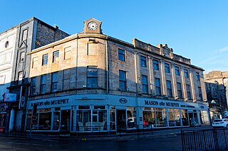
King Street is the principal business street in Kilmarnock, East Ayrshire, Scotland. King Street runs from the Kilmarnock Cross over the Kilmarnock Water and on to the junction with Titchfield Street. In recent years, proposals have surfaced to demolish some of the privately owned premises on King Street in order to open the street up to views of the Kilmarnock Water. Modern sculptures by Shona Kinloch currently line King Street.
The George Hotel is a former 5–star hotel located in Kilmarnock, Scotland. The building was built in the 19th century and is "B" Listed. The building is situated on land at the top of Portland Street. This land was once the home of Kilmarnock Bowling Club. It was one of the top hotels in the area. The George was Kilmarnock's 5-star hotel. The hotel closed in 1920. There were plans for the hotel to be demolished when the Town Council purchased the property, but the plans were changed. The same year as the George Hotel closed part of the building was adapted and used as the George Cinema.
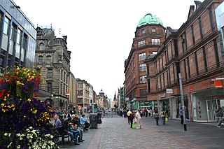
Argyle Street is a major thoroughfare in the city centre of Glasgow, Scotland.
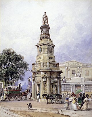
King's Cross was a short-lived building in London which gave its name to the area still known as Kings Cross. The building was erected in 1830, as the base for a memorial to the recently deceased King George IV. A statue of the late king was added in 1835, but then removed in 1842, and the structure was demolished in 1845.

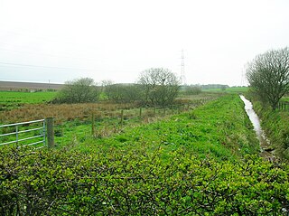
The Bickering bush (NS41863635) thorn grew near Caprington on the lands of Monksholm or Maxholm, Riccarton, East Ayrshire, Scotland. The old farm house at Maxholm sat in hollow on the old Caprington Castle estate and to the north and west its fields bordered the River Irvine. The thorn was located, as recorded on the OS map, near to the confluence of the Kilmarnock Water and the River Irvine, downstream of the Simon's Burn's confluence on the south bank of the river.


