Related Research Articles

Vilhjalmur Stefansson was an Arctic explorer and ethnologist. He was born in Manitoba, Canada.

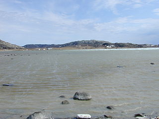
The Tree River (Kogluktualuk) is a river in Nunavut, Canada. It flows into Coronation Gulf, an arm of the Arctic Ocean.
The Duke of York Archipelago is an uninhabited island group in the Kitikmeot Region, Nunavut, Canada. It is located in the Coronation Gulf.
Ogden Bay is an Arctic waterway in the Kitikmeot Region, Nunavut, Canada. It is located in the southern Queen Maud Gulf off Nunavut's mainland. Chester Bay is situated 32 km (20 mi) to the west, Armark is to the east, and the Keith Islands are to the north.
The Rae River (Pallirk) is a waterway that flows from Akuliakattak Lake into Richardson Bay, Coronation Gulf. Its mouth is situated northwest of Kugluktuk, Nunavut. Its shores were the ancestral home of Copper Inuit subgroups: the Kanianermiut and the Pallirmiut.
Albert Edward Bay is a bay on the southeast side of Victoria Island in the Arctic Archipelago. It faces Victoria Strait to the east. There are several islands in the bay, the largest of which is Admiralty Island at its mouth. Its north side is the Collinson Peninsula.
Ahiagmiut were a geographically defined Copper Inuit subgroup in the northern Canadian territory of Nunavut. They were located near Ogden Bay, on the Queen Maud Gulf, and inland towards Back River, then on towards the Akilinik River.
Akuliakattagmiut were a geographically defined Copper Inuit subgroup in the Canadian territory of Nunavut. They were located near Cape Bexley on the south shore, mainland side of Dolphin and Union Strait, and in the vicinity of the Melville Hills' Akuliakattak Lake, the source of the Rae River.
The Ekalluktogmiut were a geographically defined Copper Inuit subgroup in Canada's Nunavut territory. They were located along the Ekalluk River near the center of Victoria Island, Albert Edward Bay in western Victoria Strait, and Denmark Bay. According to the Arctic explorer Vilhjalmur Stefansson, the Ekalluktogmiut winter hunt on Dease Strait.
Haneragmiut were a geographically defined Copper Inuit subgroup in the Canadian territory of Nunavut. They were the most westerly band of those that hunted in southern Victoria Island. They were generally located on the north shore of Dolphin and Union Strait, north of Cape Bexley, and south of Prince Albert Sound, on Victoria Island. Though they migrated seasonally both north and south for hunting, fishing, and trade, they were unaware that Victoria Island was an island.
Kogluktogmiut were a geographically defined Copper Inuit subgroup in the Canadian territory of Nunavut. They were located by Bloody Falls, a waterfall on the lower course of the Coppermine River in the Kugluk/Bloody Falls Territorial Park, notable for the Bloody Falls Massacre.
Sutton Island is located in northern Canada's territory of Nunavut. It is situated in the Dolphin and Union Strait immediately next to Liston Island. Rymer Point and Simpson Bay, on Victoria Island's Wollaston Peninsula are to the northeast. Bernard Harbour, on the mainland, is to the southwest, as is Chantrey Island.
Cape Bexley is a headland in the northern Canadian territory of Nunavut. It is located on the mainland, on the south shore of Dolphin and Union Strait, and bounded on the south by Souths Bay. It was named after Nicholas Vansittart, 1st Baron Bexley.
The Haningayogmiut were a Copper Inuit subgroup located on the Back River (Haningayok). According to Arctic explorer Vilhjalmur Stefansson, the Haningayogmiut were a small tribe. The Kaernermiut were also located on the Back River and may have been the same subgroup.

The Kangiryuarmiut are an Inuvialuit group, culturally and historically related to the Copper Inuit. They were historically located on Victoria Island in the areas of Prince Albert Sound, Cape Baring, and central Victoria island. They often travelled seasonally around their traditional territory including to Banks Island, both south to Nelson Head and as far north as Mercy Bay to collect raw materials from the wreck of HMS Investigator. Archaeologists have also found many sites left by Kangiryuarmiut and their ancestors in what is now Aulavik National Park. Today, many Kangiryurmiut still live on Victoria Island, in the hamlet of Uluhaktok, now within the Inuvialuit Settlement Region.
The Umingmuktogmiut are a geographically defined Copper Inuit band in the northern Canadian territory of Nunavut, Kitikmeot Region. They were located on the western coast of Kiillinnguyaq, and also further south in eastern Bathurst Inlet around Everitt Point by the Barry Islands. Umingmuktogmiut were notable amongst other Copper Inuit as they had a permanent community, Umingmuktog. They could hunt and fish for Arctic char, Arctic fox, barren-ground caribou, fur seals, and muskox prevalent in the area.
The Ugyuligmiut were a geographically defined Copper Inuit band in the Canadian Arctic's Northwest Territories. They were located on Victoria Island north of Minto Inlet, and on Banks Island in the Aulavik National Park region.
The Kugaryuagmiut are a geographically defined Copper Inuit band in the northern Canadian territory of Nunavut, on the mainland, in Kitikmeot Region. According to Arctic explorer Vilhjalmur Stefansson's 1908-1912 ethnographic journals, they numbered about 25 at the time. In the summer, they hunted in the region of the Kugaryuak River, which flows into the Coronation Gulf, where they subsisted during the winter, the same as other Copper Inuit of that region.
The Pingangnaktok are a geographically defined Copper Inuit band in the northern Canadian territory of Nunavut, on the mainland, in Kitikmeot Region. According to Arctic explorer Vilhjalmur Stefansson's 1908-1912 ethnographic journals, they numbered about 30 at the time. In the summer, they hunted to the west of Tree River, which flows into the Coronation Gulf, where they hunted during the winter, the same as other Copper Inuit of that region.
The Roscoe River is a waterway located above the Arctic Circle on the mainland of Northern Canada.
References
- ↑ Stefansson, Vilhjalmur (1914). The Stefánsson-Anderson Arctic expedition of the American museum: preliminary ethnological report. Vol. 25, Part 1 of Anthropological papers of the American Museum of Natural History (Digitized Oct 9, 2007 ed.). The Trustees. p. 32.
- ↑ "Stefansson, Vilhjalmur. Prehistoric and Present Commerce Among the Arctic Coast Eskimo. 1914. Reprint. London: Forgotten Books, 2013. 14-5. Print". Archived from the original on 2014-04-21. Retrieved 2014-04-20.
- ↑ "Snow goggles". civilization.ca. Retrieved 2009-10-06.