King's Norton, Leicestershire

Last updated

King's Norton direction post King's Norton - geograph.org.uk - 500579.jpg
King's Norton direction post

King's Norton is a village and civil parish in the Harborough district of Leicestershire, England. It is situated to the east of Leicester, and about 2+12 miles (4 km) south-west from Billesdon. According to the 2001 census the parish had a population of 69. At the 2011 census the population remained less than 100 and is included in the civil parish of Gaulby.

Contents

There is a small cluster of houses around the junction of three roads which lead to Gaulby, Little Stretton, and Illston on the Hill; this includes the manor-house, Vicarage, and church. In 1563 there were 12 households, in 1670 there were 17 households. The maximum known population was just over 60 in the 19th century. [1]

Manor house and other houses

The L-shaped manor house is adjacent to the east end of the church. Most of the two storey (plus attics) main structure was probably built by William Whalley (d.1635) or his son Ralph. Sash windows were inserted into the main wing (red brick on an ironstone plinth) in the early 18th century. There is a mid-17th century staircase which has been altered. The old kitchen was in the smaller wing; the kitchen is now in a previous brew-house c.1800. The roof of this wing has an arch-braced collar-beam truss. [1]

Also on this plot is a square brick dovecote with a small diaper pattern (poss. later 17th century). There is a tablet dated 1726 with the initials of Bernard and Anne Whalley on another building. [1]

Other notable buildings are The Limes, Wyggeston Farm (c1700 plus older fragments), a timber-framed cottage, Lime Cottage (18th century brick), The Grange (1870, formerly The Laurels), the village hall (1921 from Co-operative Society). [1]

Church

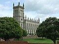
The Gothic Revival church of St. John the Baptist was built at the cost of just over £20,000 in a little over one year at the commission of Squire William Fortrey. It was designed by local architect John Wing the Younger (1728–94) of North Luffenham. The spire was added in 1775 but destroyed in a storm in 1850.

The interior has hardly changed: the central three-decker pulpit, box pews and west gallery remain, lit by clear windows. Outside at its east end is a monument to William Fortrey, and close by is the 17th-century Fortrey manor house.

Related Research Articles

<span class="mw-page-title-main">Chirton</span> Human settlement in England

Chirton is a village and civil parish in Wiltshire, England, on the southern edge of the Vale of Pewsey about 5 miles (8 km) south-east of Devizes. The parish includes the hamlet of Conock, about half a mile west of Chirton village.

<span class="mw-page-title-main">King's Sutton</span> Human settlement in England

King's Sutton is a village and civil parish in West Northamptonshire, Northamptonshire, England in the valley of the River Cherwell. The village is about 4.1 miles (6.6 km) south-east of Banbury, Oxfordshire.

<span class="mw-page-title-main">Drayton, Leicestershire</span> Human settlement in England

Drayton is a small village and civil parish in the Harborough district of south-east Leicestershire, bordering Northamptonshire and Rutland. It is situated 6.7 miles (11 km) northeast of Market Harborough and 5 miles (7.5 km) southwest of Uppingham on the north side of the Welland valley. Nearby villages are Bringhurst, Great Easton and Nevill Holt. The church of St James in Drayton is one of the smallest churches in England.

<span class="mw-page-title-main">Weobley</span> Village in Herefordshire, England

Weobley is an ancient settlement and civil parish in Herefordshire, England. Formerly a market town, the market is long defunct and the settlement is today promoted as one of the county's black and white villages owing to its abundance of old timber-framed buildings. Although it has the historical status of a town and is referred to as such in the sources, it nowadays refers to itself as a village.

<span class="mw-page-title-main">Gaulby</span> Human settlement in England

Gaulby is a village in Leicestershire, England, 7 miles east of the city of Leicester. According to the 2001 census it had a population of 131,. The 2011 census for Gaulby returned 52 houses and 141 residents.

<span class="mw-page-title-main">Saracen's Head</span> Group of late medieval buildings in Kings Norton, Birmingham

The Saracen's Head is the name formerly given to a group of late medieval buildings in Kings Norton, Birmingham. The buildings, together with the nearby Old Grammar School, won the BBC Restoration series in 2004. Following the restoration project, the Old Grammar School, Saint Nicolas Church and the Tudor Merchant's House were given the collective name of Saint Nicolas Place.

Little Hautbois is a small hamlet in Broadland, England, part of the parish of Lamas. The name is pronounced 'Hobbis', and can be seen thus spelled on a memorial on the outside of nearby Lamas Church. The population of the hamlet is included in the civil parish of Buxton with Lamas. In the Middle Ages, the settlement of Great Hautbois was the head of the navigation on the River Bure, and it is thought Little Hautbois developed from that. The name, which can be translated to "High Woods" in English, is taken from that of the de Alto Bosco, or de Haut Bois, family, who acquired these lands at the Norman Conquest (alternatively, they may have taken the name from the settlement, Blomefield being uncertain on this point.

<span class="mw-page-title-main">Peckforton</span> Human settlement in England

Peckforton is a scattered settlement and civil parish in the unitary authority of Cheshire East and the ceremonial county of Cheshire, England. The settlement is located 6.5 miles (10.5 km) to the north east of Malpas and 7.5 miles (12.1 km) to the west of Nantwich. The civil parish covers 1,754 acres (710 ha), with an estimated total population of 150 in 2006. The area is predominantly agricultural. Nearby villages include Bulkeley to the south, Beeston to the north, Higher Burwardsley to the west, Spurstow to the east and Bunbury to the north east.

<span class="mw-page-title-main">Wistow, Leicestershire</span> Human settlement in England

Wistow is a deserted medieval village and civil parish in the Harborough district, in the English county of Leicestershire, and lies seven miles south-east of the city of Leicester in the valley of the River Sence. Since 1 April 1936 it has included most of the former civil parish of Newton Harcourt which was a chapelry of Wistow. The population of the civil parish at the 2011 census was 256.

<span class="mw-page-title-main">Blackstone, West Sussex</span> Parish in West Sussex, England

Blackstone is a hamlet in the civil parish of Woodmancote and the Horsham district of West Sussex, England. Blackstone is significant for its listed 17th- and 18th-century houses and cottages.

<span class="mw-page-title-main">Cornwell, Oxfordshire</span> Human settlement in England

Cornwell is a small village and civil parish about 2.5 miles (4 km) west of Chipping Norton in the West Oxfordshire district of Oxfordshire, near the county border with Gloucestershire. The 2001 Census recorded the parish's population as 66.

<span class="mw-page-title-main">East Worldham</span> Human settlement in England

East Worldham is a village and former civil parish, now in the parish of Worldham, in the East Hampshire district of Hampshire, England. It is 1.9 miles (3.1 km) east of Alton; and 1.9 miles (3.1 km) south-west of Wyck. Hartley Mauditt and West Worldham are nearby, which, along with East Worldham, form the parish of Worldham. The village is just east of the A31 road and contains St Mary's Church and the Three Horse Shoes pub, amongst other buildings. Worldham Golf Course located just to west and Dean Farm Golf Course just to the east. For centuries the village and surrounding parish were owned by Winchester College. In 1931 the parish had a population of 208.

<span class="mw-page-title-main">Chevington, Suffolk</span> Human settlement in England

Chevington is a village and civil parish in the West Suffolk district of Suffolk in East Anglia, England. Located around 10 km south-west of Bury St Edmunds, in 2005 its population was 630, reducing to 602 at the 2011 Census. The parish also contains the hamlets of Broad Green and Tan Office Green.

<span class="mw-page-title-main">Tidmington</span> Human settlement in England

Tidmington is a village and civil parish in the Stratford-on-Avon District of Warwickshire, England. It is 11 miles (18 km) south from the town of Stratford-upon-Avon, and at the extreme southern edge of the county bordering Gloucestershire. Within the parish is the Grade II* listed c.1600 Tidmington House, and the Grade II* early 13th-century church of unknown dedication. At the 2001 Census, which for statistical purposes now includes the neighbouring parish of Burmington, the combined population was 153.

<span class="mw-page-title-main">Bredicot</span> Human settlement in England

Bredicot is a small village and civil parish in Worcestershire, England, about 4 miles (6.4 km) east of Worcester.

<span class="mw-page-title-main">Todenham</span> Human settlement in England

Todenham is a village and civil parish in the Cotswold district of Gloucestershire, England. The village is significant for its Grade I listed 14th-century parish church.

<span class="mw-page-title-main">Pencombe with Grendon Warren</span> Human settlement in England

Pencombe with Grendon Warren is a civil parish in the county of Herefordshire, England. The parish was created in 1895 from the parishes of Pencombe and Grendon Warren, its only nucleated settlement being the village of Pencombe.

<span class="mw-page-title-main">Norton, Herefordshire</span> Human settlement in England

Norton is a civil parish in north-east Herefordshire, England, and is approximately 14 miles (23 km) north-east from the city and county town of Hereford. The closest town is Bromyard, conjoined to the parish at the south-west. The parish includes the elevated public open common land of Bromyard Downs.

<span class="mw-page-title-main">Edvin Loach and Saltmarshe</span> Human settlement in England

Edvin Loach and Saltmarshe is a civil parish in north-east Herefordshire, England, and is approximately 15 miles (24 km) north-east from the city and county town of Hereford. The nearest town is Bromyard, 2.5 miles (4 km) to the south-west. Within the parish is a George Gilbert Scott built parish church in the virtually depopulated settlement of Edvin Loach, and the repurposed site of the demolished Saltmarshe Castle.

<span class="mw-page-title-main">Letton, West Herefordshire</span> Human settlement in England

Letton is a village and civil parish in west Herefordshire, England, and is approximately 11 miles (20 km) west-northwest from the city and county town of Hereford. The parish contains the village of Letton, the hamlet of Waterloo, and the farming hamlets of Hurstley and Kinley. The nearest towns are the market towns of Hay-on-Wye 7 miles (11 km) to the west, and Kington 7 miles to the north. Within Letton is the Grade I listed Church of St John the Baptist, and The Sturts nature reserve and Site of Special Scientific Interest.

References

  1. 1 2 3 4 "Victoria County History". British History Online. VCH. Retrieved 21 November 2015.

52°35′53″N0°59′06″W / 52.598°N 0.985°W / 52.598; -0.985