Gaulby

Last updated

Gaulby
Gaulby.jpg
Gaulby Church
Leicestershire UK location map.svg
Red pog.svg
Gaulby
Location within Leicestershire
Population141 (2011)
OS grid reference SK691010
District
Shire county
Region
Country England
Sovereign state United Kingdom
Post town LEICESTER
Postcode district LE7
Police Leicestershire
Fire Leicestershire
Ambulance East Midlands
List of places
UK
England
Leicestershire
52°36′11″N0°58′48″W / 52.603°N 0.980°W / 52.603; -0.980 Coordinates: 52°36′11″N0°58′48″W / 52.603°N 0.980°W / 52.603; -0.980

Gaulby (or Galby) is a village in Leicestershire, England, 7 miles east of the city of Leicester. According to the 2001 census it had a population of 131, (including Frisby). [1] The 2011 census for Gaulby returned 52 houses and 141 residents. [2]

Contents

History

The village's name means 'farm/settlement which is gall', probably meaning it had poor, wet ground. [3]

In the Domesday Book of 1086 the village was recorded as Galbi, one of 230 manors in Leicestershire held by Hugh de Grandmesnil. Through the 12th and 13th centuries the manor was held by the Earls of Leicester, the last Earl being John of Gaunt, Duke of Lancaster (died 1399).

Subsequently, the title of Lord of the Manor passed to the Marmion family and thence by marriage to the Haselwood family. In 1610 William Whalley, Lord of the Manor of King's Norton, Leicestershire, purchased the lands from the Haselwoods for £600. He received 663 acres (300 each of arable and pasture), 8 messuages (substantial dwellings with outbuildings and attached land), 4 cottages, a windmill and a dovecote. Excluded from this purchase were the Rectory and the lands of the Dands and Goodmans. From 1614 Whalley, John Dand and George Goodman, by private agreement, carried out piecemeal land enclosure of the open field system. This process was completed in 1649.

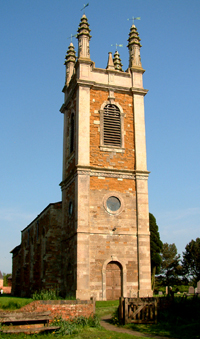
His descendant, Bernard Whalley, died in 1752, and the two manors were inherited by William Fortrey through Fortrey's mother, who was a Whalley. Fortrey financed the rebuilding of the nave and tower of the parish church of St. Peter in 1741. The church had previously been rebuilt in 1520, and from this 16th-century building the chancel and communion rail survive as the then vicar, Thomas Shaw, refused to let Fortrey touch it. The architect was John Wing the Elder (1698-1753).

On Fortrey's death his nephew Henry Green inherited the manors. In 1791 they were sold to Peers Anthony Keck of Stoughton Grange, and they remained in the hands of the Keck family until 1913 when the majority of the land was sold to the Co-Operative Society and the Wyggeston Hospital Charitable Trust. [4]

Related Research Articles

Earl Shilton Town in Leicestershire, England

Earl Shilton is a market town in Leicestershire, England, about 5 miles (8 km) from Hinckley and about 10 mi (16 km) from Leicester. The 2011 Census recorded its population as 10,047.

The Lee Human settlement in England

The Lee is a village in Buckinghamshire, England. It is located in the Chiltern Hills, about 2 mi north east of Great Missenden and 3 mi south east of Wendover. The Lee is also the name of a civil parish within Chiltern District. Within the parish is the hamlet of Lee Clump, named for a small group of houses separate from the main village.

Frisby on the Wreake Human settlement in England

Frisby on the Wreake is a village and civil parish on the River Wreake about 3.5 miles (5.6 km) west of Melton Mowbray, Leicestershire, England. The 2011 Census recorded the parish's population as 557.

Wycomb Village in United Kingdom

Wycomb is a small hamlet in the district of Melton Mowbray, which is approximately 4 miles (6.4 km) northeast of Melton Mowbray in Leicestershire, and is part of the civil parish of Scalford, which also includes the neighbouring village of Chadwell. The population of the civil parish at the 2011 census was 608.

Groby Human settlement in England

Grobylisten  is a large English village in the county of Leicestershire, to the north west of the city of Leicester. The population at the time of the 2011 census was 6,796.

Myddle Human settlement in England

Myddle—also formerly known as Mydle, Middle, Midle, M'dle, Meadley and Medle—is a small village in Shropshire, England, about 10 miles north of Shrewsbury, the county town of Shropshire. Myddle lies in the parish of Myddle, Broughton and Harmer Hill. The 2001 census recorded a population of 1,142 in the village, rising to 1,333 at the 2011 census.

Knaptoft Human settlement in England

Knaptoft is a deserted medieval village and civil parish in the Harborough district of Leicestershire and lies approximately 9.7 miles (15.6 km) south of the city of Leicester, England. According to the University of Nottingham English Place-names project, the settlement name Knaptoft could mean 'cnafa' A boy, a young man, a servant, a menial, or a personal name, and 'toft' the plot of ground in which a dwelling stands. The population of the civil parish at the 2011 census was 47.

Braunstone Town Human settlement in England

Braunstone is a civil parish and is the largest parish within the district of Blaby in Leicestershire, England, now known as the Town of Braunstone or more commonly, Braunstone Town. In 2007 the population was around 15,000. There are around 7,500 households including Thorpe Astley. At the 2011 census the population of the civil parish had increased to 16,850.

Kings Norton, Leicestershire

King's Norton is a village and civil parish in the Harborough district of Leicestershire, England. It is situated to the east of Leicester, and about 2+12 miles (4 km) south-west from Billesdon. According to the 2001 census the parish had a population of 69. At the 2011 census the population remained less than 100 and is included in the civil parish of Gaulby.

Frisby, Leicestershire Human settlement in England

Frisby is a hamlet and civil parish in the Harborough district of Leicestershire that lies approximately 7.3 miles (11.7 km) southeast of the city of Leicester, that is now largely a deserted medieval village. According to the University of Nottingham English Place-names project, the settlement name Frisby could mean 'farm/settlement of the Frisians'. The 2011 census for Frisby returned 5 houses and 16 residents. Often termed as Frisby by Gaulby, the modern hamlet is situated between the village of Gaulby 1 mile (1.6 km) to the southwest and Billesdon 1.94 miles (3.12 km) to the northeast. The deserted part of the ancient hamlet is a Scheduled Ancient Monument and can be located on the eastern side of the lane that leads down the hill from Gaulby Road, via Frisby House on a south-eastwards direction. The earthwork "tofts & crofts" are still visible today, with foundations for two stone built buildings noted towards the center of the site.

Pickwell

Pickwell is a small, hill-crest village 5 miles (8.0 km) south-east of Melton Mowbray in Leicestershire which used to have an ecclesiastical parish of its own and is since the early 20th century has been in the civil parish and Church of England parish of Somerby which is 0.5 miles (0.80 km) to the SSW, connected by an almost straight lane. The population of the village at the 2011 census was included in the civil parish of Somerby.

Newton Harcourt Human settlement in England

Newton Harcourt is a village in the English county of Leicestershire and lies 7 miles south-east of the city of Leicester on the northern ridge of the River Sence valley. Since 1936 it has been part of the civil parish of Wistow. The population of the civil parish at the 2011 census was 256. Administratively, Newton Harcourt forms part of the civil parish of Wistow and of the district of Harborough.

Thorpe Arnold Village in Leicestershire, England

Thorpe Arnold is a small farming village in the district of Melton Mowbray, which is approximately 1.2 miles (1.9 km) northeast of Melton Mowbray in Leicestershire, and is part of the civil parish of Waltham on the Wolds & Thorpe Arnold. The population of the civil parish at the 2011 census was 967.

Chadwell, Leicestershire Village in United Kingdom

Chadwell is a small village in the district of Melton Mowbray, which is approximately 4 miles (6.4 km) northeast of Melton Mowbray in Leicestershire, and is part of the civil parish of Scalford, which also includes the neighbouring hamlet of Wycomb. The population of the civil parish at the 2011 census was 608. The village name means 'spring/stream which is cold'. Chadwell is half a mile east of Wycomb, and they share the Church of St. Mary in the same ecclesiastical parish. The Church of St Mary is a Grade II* Listed building.

George Anthony Legh Keck British politician

Colonel George Anthony Legh-Keck (1774–1860) was a British MP in the Georgian era who owned landed estates in Leicestershire and Lancashire.

Donington le Heath Human settlement in England

Donington le Heath is a village on the River Sence just over 1 mile (1.6 km) south of the centre of Coalville in North West Leicestershire. Donington is contiguous with the village of Hugglescote immediately to the east. The population of the village is included in the civil parish of Hugglescote and Donington le Heath.

Honour of Clitheroe

The Honour of Clitheroe is an ancient grouping of manors and royal forests centred on Clitheroe Castle in Lancashire, England; an honour traditionally being the grant of a large landholding complex, not all of whose parts are contiguous. In the case of Clitheroe, this complex was loosely clustered around the ancient wapentake of Blackburnshire.

Stoughton Grange was a country house in the parish of Stoughton in Leicestershire and the family seat of the Farnham and Beaumont family. The house dated back to 15th century but was demolished in 1926, after being a successful family home for over five hundred years.

Lowesby Hall Country house in Leicestershire, UK

Lowesby Hall is a large Grade II* Georgian mansion in the parish and former manor of Lowesby, eight miles east of Leicester in Leicestershire. It is a famous fox-hunting seat in the heart of the Quorn country. The poem "Lowesby Hall" by the Victorian English foxhunting MP William Bromley Davenport (1821–1884) was a parody on Alfred Tennyson's 1835 poem Locksley Hall.

Sir ManserMarmion, of Ringstone in Rippingale and Galby was an English Member of Parliament and Sheriff of Lincolnshire.

References

  1. ""Area: Gaulby CP (Parish)"". Archived from the original on 12 June 2011. Retrieved 18 April 2008.
  2. "Population (2011)". doogal.co.uk. doogal.co.uk. Retrieved 17 August 2022.
  3. "Key to English Place-names". kepn.nottingham.ac.uk. Archived from the original on 10 August 2021. Retrieved 31 August 2021.
  4. Goldsmith, S.P.M. Gaulby. Manor House, Gaulby 1988

Bibliography

Commons-logo.svg Media related to Gaulby at Wikimedia Commons