
Renfrewshire is one of the 32 council areas of Scotland. Renfrewshire is located in the west central Lowlands. It borders East Renfrewshire, Glasgow, Inverclyde, North Ayrshire and West Dunbartonshire, and lies on the southern bank of the River Clyde. The current council area of Renfrewshire was established in 1996. The town of Paisley is the area's main settlement and centre of local government. The area also contains the historic county town of Renfrew.

Braehead is a commercial development located at the former site of Braehead Power Station in Renfrew on the south bank of the River Clyde in Renfrew, Renfrewshire. It is particularly notable for its large shopping centre, arena and leisure facilities.

Dunbartonshire or the County of Dumbarton is a historic county, lieutenancy area and registration county in the west central Lowlands of Scotland lying to the north of the River Clyde. Dunbartonshire borders Perthshire to the north, Stirlingshire to the east, Lanarkshire and Renfrewshire to the south, and Argyllshire to the west.

Port Glasgow is the second-largest town in the Inverclyde council area of Scotland. The population according to the 1991 census for Port Glasgow was 19,426 persons and in the 2001 census was 16,617 persons. The most recent census in 2011 states that the population has declined to 15,414. It is located immediately to the east of Greenock and was previously a burgh in the county of Renfrewshire.

Netherlee is a suburban residential area in East Renfrewshire, Scotland. It is situated on the west bank of the White Cart Water about 4 miles (6.5 km) south of Glasgow city centre. Part of the Greater Glasgow conurbation, it is mostly contiguous with the city, and is just beyond the boundary of its local authority area. It is a separate census locality from Glasgow, like other areas such as neighbouring Giffnock and Clarkston. Netherlee is directly contiguous with Stamperland. It is also in a council ward with Clarkston and its neighbour Busby. As of 2012, Netherlee has a population of 4,550.

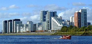
Greater Glasgow is an urban settlement in Scotland consisting of all localities which are physically attached to the city of Glasgow, forming with it a single contiguous urban area. It does not relate to municipal government boundaries, and its territorial extent is defined by National Records of Scotland, which determines settlements in Scotland for census and statistical purposes. Greater Glasgow had a population of 1,199,629 at the time of the 2001 UK Census making it the largest urban area in Scotland and the fifth-largest in the United Kingdom. However, the population estimate for the Greater Glasgow 'settlement' in mid-2016 was 985,290—the reduced figure explained by the removal of the Motherwell & Wishaw (124,790), Coatbridge & Airdrie (91,020), and Hamilton (83,730) settlement areas east of the city due to small gaps between the populated postcodes. The 'new towns' of Cumbernauld and East Kilbride (75,120) were never included in these figures despite their close ties to Glasgow due to having a clear geographical separation from the city. In the 2020 figures, the Greater Glasgow population had risen to just over 1 million.

Glasgow South is a burgh constituency of the House of Commons of the Parliament of the United Kingdom (Westminster). It elects one Member of Parliament (MP) by the first past the post system of election.

Inverclyde was a parliamentary constituency of the House of Commons of the Parliament of the United Kingdom. It replaced Greenock and Inverclyde and the Port Glasgow and Kilmacolm areas from West Renfrewshire for the 2005 general election.

Paisley and Renfrewshire South is a constituency of the House of Commons, located in Renfrewshire, Scotland to the southwest of Glasgow. It elects one member of Parliament at least once every five years using the first-past-the-post system of voting.

Paisley and Renfrewshire North is a constituency of the House of Commons of the Parliament of the United Kingdom. It was created for the 2005 general election, replacing most of Paisley North and Renfrewshire West.

Shieldhall is a district in the Scottish city of Glasgow. It is situated directly south of the River Clyde and is part of the wider Govan area.
Glasgow Harbour is a private sector urban regeneration scheme at Partick in the West End of the city of Glasgow, Scotland. It is not the history and development of the wider and internationally famous Glasgow Harbour from Glasgow Green to Clydebank which developed from the early 1800s and witnessed the birth and growth of modern shipbuilding and shipping.

Renfrewshire or the County of Renfrew is a historic county, registration county and lieutenancy area in the west central Lowlands of Scotland. The lieutenancy area covers the three modern council areas of Inverclyde, Renfrewshire and East Renfrewshire, and this area is occasionally termed Greater Renfrewshire to distinguish it from the modern council area called Renfrewshire. The historic county additionally included territory on the south-western edge of Glasgow which was gradually transferred to the administrative area of the city as it grew.

The Renfrew Ferry is a passenger ferry service linking the north and south banks of the River Clyde in Scotland. The service, operated by Clydelink without subsidy, crosses between Renfrew and Yoker, close to Glasgow City Centre and is the last Clyde crossing this far upstream.

West Renfrewshire was a constituency of the Scottish Parliament (Holyrood). It elected one Member of the Scottish Parliament (MSP) by the first past the post method of election. Also, however, it was one of nine constituencies in the West of Scotland electoral region, which elected seven additional members, in addition to nine constituency MSPs, to produce a form of proportional representation for the region as a whole.
Dykebar is a small residential estate at the south-easternmost periphery of Paisley, Renfrewshire, Scotland, close to the local authority boundaries with both East Renfrewshire and Glasgow. It is situated next to the Hawkhead area, with other neighbourhoods in the vicinity including Thornly Park, Lochfield, Hunterhill and Blackhall. Dykebar is home to Paisley's general psychiatric hospital, and is approximately 1.2 miles (1.9 km) from both Barrhead and Nitshill.

Renfrew is a town 6 miles (10 km) west of Glasgow in the west central Lowlands of Scotland. It is the historic county town of Renfrewshire. Called the "Cradle of the Royal Stewarts" for its early link with Scotland's former royal house, Renfrew gained royal burgh status in 1397.

George V Bridge is a three-arched road bridge over the River Clyde in the city centre of Glasgow, Scotland, named after King George V.
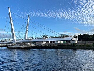
The New River Clyde bridge is a current construction as part of the ongoing Clyde Waterfront Regeneration. Scheduled for completion in March 2025, it will be the first new vehicle crossing point on the Clyde since the Clyde Arc bridge was built in 2006.

The disused Park Quay or Fulton's Quay is located on the old Lands of Park, situated on the south bank of the River Clyde in the Parish of Inchinnan, close to Newshot Island and the old Rashielee Quay. A slipway is also part of the infrastructure, giving access to the dock at low tide, both once served by roads running through the Park Estate from the south. It was recorded as Fulton's Quay in 1830, the name of a previous owner of the Park Estate who may have built it prior to 1801. A fixed light was installed at Park Quay in 1869.
