
The Arctic Archipelago, also known as the Canadian Arctic Archipelago, groups together all islands lying to the north of the Canadian continental mainland excluding Greenland.

King County is located in the U.S. state of Washington. The population was 2,252,782 in the 2019 census estimate, making it the most populous county in Washington, and the 12th-most populous in the United States. The county seat is Seattle, also the state's most populous city.
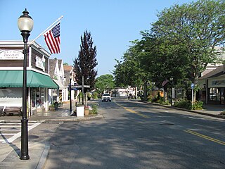
Falmouth is a census-designated place (CDP) consisting of the primary settlement in the town of Falmouth in Barnstable County, Massachusetts, United States. The population of the CDP was 3,799 at the 2010 census, out of 31,532 in the town as a whole. It was named after Falmouth, Cornwall, England.
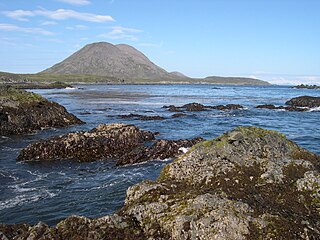
Sanak Island is an island in the Fox Islands group of the Aleutian Islands in the U.S. state of Alaska. It is located at 54°25′47″N162°42′32″W.
Bridlington was a rural district in the East Riding of Yorkshire in England from 1894 to 1974. It covered a coastal area, and surrounded the municipal borough of Bridlington on its land borders. The district covered Flamborough and Flamborough Head.
Moneyslane is a small village and townland in County Down, Northern Ireland, on the main route from Castlewellan to Banbridge. In the 2001 Census it had a population of 147. It lies within the District of Banbridge.
Broad Cove is on King's Island, Placentia Bay, Newfoundland, Canada. It was one of five communities on King's Island; the others were: Tack's Beach, Best Harbour, Baker's Cove, Cooper's Cove and Yaulis Cove. All the communities had the same postal address, which was "Tacks Beach, Placentia Bay, Newfoundland".

Tack's Beach was a small community located on King Island in Placentia Bay. The population was 252 in 1921. The population had declined to 140 by 1966 due to a decline in fish stocks and the community was depopulated in 1967.
Shin-Fukae Station is a railway station on the Osaka Metro Sennichimae Line in Higashinari-ku, Osaka, Japan.
Cedar Creek may refer to several small streams in the U.S. state of Michigan:

Bir El Djir is a district in Oran Province, Algeria, on the Mediterranean Sea. It was named after its capital, Bir El Djir.

Fletton railway station was a railway station in Fletton, Cambridgeshire just south of Peterborough. It was once home to an extensive goods yard.
Ulvingen Island is one of the uninhabited islands in Qikiqtaaluk Region, Nunavut, Canada. It is located in Norwegian Bay between Axel Heiberg Island and Ellesmere Island's Raanes Peninsula. It is a member of the Sverdrup Islands, Queen Elizabeth Islands, and the Canadian Arctic Archipelago. Hare Point is situated at the island's southern tip.
Uilortussoq Island is an island of Greenland. It is located in Baffin Bay in the Upernavik Archipelago.
Stephens Island is an island on the British Columbia Coast, Canada, located in Hecate Strait to the northwest of Porcher Island and to the southwest of the city of Prince Rupert. The island's main geographic feature is Mount Stephens, 432 m, on the southeast end of the island at 54°07′39″N130°40′15″W. To its northwest is Congreve Hill, 150 m, at 54°09′29″N130°42′31″W.
Division No. 1, Subdivision B is an unorganized subdivision on the Avalon Peninsula in Newfoundland and Labrador, Canada. It is in Division 1 and contains the unorganized communities of Iona, Little Barasway, Placentia Junction, Point Verde and Ship Harbour.
Lilienthal Mountain is a 3,550-foot (1,080 m) or 3,568-foot (1,088 m) peak on the Columbia Plateau in Lincoln County, in the U.S. state of Washington. It is the highest point in Lincoln County.
This page is based on this
Wikipedia article Text is available under the
CC BY-SA 4.0 license; additional terms may apply.
Images, videos and audio are available under their respective licenses.
