Related Research Articles

Ellis County is a county located on the western border of the U.S. state of Oklahoma. As of the 2010 census, the population was 4,151, making it the fifth-least populous county in Oklahoma. Its county seat is Arnett.

Comanche County is a county located in the U.S. state of Kansas. As of the 2020 census, the county population was 1,689. Its county seat and most populous city is Coldwater. The county is named after the Comanche Native Americans.

The Smoky Hill River is a 575-mile (925 km) river in the central Great Plains of North America, running through Colorado and Kansas.
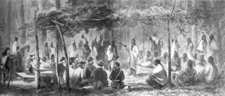
The Medicine Lodge Treaty is the overall name for three treaties signed near Medicine Lodge, Kansas, between the Federal government of the United States and southern Plains Indian tribes in October 1867, intended to bring peace to the area by relocating the Native Americans to reservations in Indian Territory and away from European-American settlement. The treaty was negotiated after investigation by the Indian Peace Commission, which in its final report in 1868 concluded that the wars had been preventable. They determined that the United States government and its representatives, including the United States Congress, had contributed to the warfare on the Great Plains by failing to fulfill their legal obligations and to treat the Native Americans with honesty.
The Owyhee River is a tributary of the Snake River located in northern Nevada, southwestern Idaho and southeastern Oregon in the United States. It is 280 miles (450 km) long. The river's drainage basin is 11,049 square miles (28,620 km2) in area, one of the largest subbasins of the Columbia Basin. The mean annual discharge is 995 cubic feet per second (28.2 m3/s), with a maximum of 50,000 cu ft/s (1,400 m3/s) recorded in 1993 and a minimum of 42 cu ft/s (1.2 m3/s) in 1954.

The Cimarron River extends 698 miles (1,123 km) across New Mexico, Oklahoma, Colorado, and Kansas. The headwaters flow from Johnson Mesa west of Folsom in northeastern New Mexico. Much of the river's length lies in Oklahoma, where it either borders or passes through eleven counties. There are no major cities along its route. The river enters the Oklahoma Panhandle near Kenton, Oklahoma, crosses the southeastern corner of Colorado into Kansas, reenters the Oklahoma Panhandle, reenters Kansas, and finally returns to Oklahoma where it joins the Arkansas River at Keystone Reservoir west of Tulsa, Oklahoma, its only impoundment. The Cimarron drains a basin that encompasses about 18,927 square miles (49,020 km2).
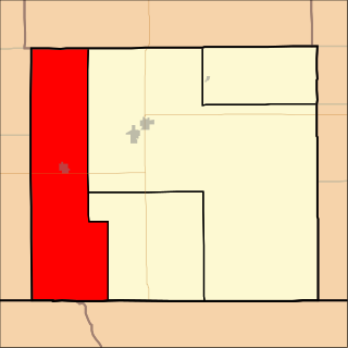
Protection Township is a township in Comanche County, Kansas, United States. As of the 2000 census, its population was 734.

Kiowa Rural Township is the sole township in Kiowa County, Kansas, United States. The population was 3,278 at the 2000 census, out of whom 2,346 lived in one of the township's three cities and 813 lived in unincorporated areas of the township. Kiowa Rural Township's boundaries are identical to those of Kiowa County: there are no other townships in the county, and none of the county's cities are governmentally independent.
The Carrizo Creek of New Mexico and Texas is a 145-mile-long (233 km) river. It is a tributary of Rita Blanca Creek, itself a tributary of the Canadian River. Via the Arkansas and Mississippi rivers, water from Carrizo Creek eventually reaches the Gulf of Mexico. It is sometimes also known as the Carrizo River.
Kiowa Creek is a watercourse in Texas and Oklahoma that becomes a tributary of the Beaver River. It originates southwest of Huntoon and east of Perryton in northeastern Ochiltree County, Texas. It travels generally east until southwest of Darrouzett in Lipscomb County, then turns northeast and passes just south and east of that town. It continues generally northeasterly into Beaver County, Oklahoma, where it is joined by Camp Creek. The stream enters Harper County west of Laverne, Oklahoma, and continues to its joinder with the Beaver River north-northwest of Laverne.

The Cimarron Redoubt was an improvised U.S. Army fortification south of the city of Ashland in Clark County, Kansas, United States. Built in 1870 near a major trade route's crossing of the Cimarron River, it was later used for a variety of civilian purposes, including a post office. Today, it lies abandoned amid farm fields in southern Center Township.
Northeast Branch Anacostia River is a 3.2-mile-long (5.1 km) free-flowing stream in Prince George's County, Maryland. It is a tributary of the Anacostia River, which flows to the Potomac River and the Chesapeake Bay.
K-34 is a 29.26-mile-long (47.09 km) state highway in southwestern Kansas that runs from U.S. Route 160 (US-160) and US-183 near Ashland to US-400 near Bucklin. It is one of the lesser-traveled highways in the state and is not part of the National Highway System. It is a two-lane road for its entire length.
Palo Flechado Pass, also called Taos Pass and Old Taos Pass, is a mountain pass located in Taos County, New Mexico on the Enchanted Circle Scenic Byway.
South Carrizo Creek forms either just west of the Oklahoma line in New Mexico, or east inside Oklahoma to the northwest of Wheeless, Oklahoma. It is intermittent. It travels generally northeast through Black Mesa State Park where it is impounded to form Lake Carl Etling, before being joined by Willow Creek and continuing northeast to flow into the Cimarron River.
East Carrizo Creek rises in Las Animas County, Colorado north of Mt. Carrizo and east of Kim, Colorado, and flows generally southeast before turning south. It joins with West Carrizo Creek at a point about 6 miles north of the Preston Monument to form North Carrizo Creek. North Carrizo Creek then flows generally south-southeast into Oklahoma to join the Cimarron River northeast of Kenton, Oklahoma.
Carrizo Creek forms in Arizona north of Cibecue, before flowing generally southeast, being joined by Corduroy Creek around the town of Carrizo, and continuing generally south to join the Salt River.
Carrizozo Creek is a watercourse in the northeast corner of New Mexico, with a small portion extending into the northwestern Oklahoma Panhandle. The creek originates northwest of Clayton Lake State Park and northeast of Grenville, New Mexico about halfway to the Colorado border, being just north of Corrumpa Creek and just west of New Mexico State Road 370. It meanders generally east-northeast into Oklahoma, loops northwest heading back into New Mexico, and then turns generally east flowing into Oklahoma again. Where Carrizozo Creek and the Dry Cimarron River come together in Cimarron County, Oklahoma west of Kenton, the Cimarron River is formed.
Lake Frederick is a reservoir in Tillman County, Oklahoma. It is located about 15 miles northeast of the town of Frederick, which owns it. It was constructed in 1974 for flood control and to provide a water supply. It has a total surface area of 878 acres, and a total volume of 9,663 acre-feet. It has about 18 miles of shoreline.
References
- 1 2 "Kiowa Creek". Natural Atlas. Retrieved August 20, 2021.
- ↑ "Clark County, Kansas". Google Maps. Retrieved August 21, 2021.
- ↑ "West Kiowa Creek". Natural Atlas. Retrieved August 20, 2021.
- 1 2 3 "Kiowa County, Kansas". Google Maps. Retrieved August 21, 2021.
- ↑ "Clark County, Kansas". Google Maps. Retrieved August 21, 2021.
- 1 2 "Comanche County, Kansas". Google Maps. Retrieved August 21, 2021.
- ↑ "Middle Kiowa Creek, Kansas". Google Maps. Retrieved August 21, 2021.
- ↑ "Middle Kiowa Creek". Natural Atlas. Retrieved August 20, 2021.
- ↑ "Protection Township Kansas". Google Maps. Retrieved August 21, 2021.
- ↑ "East Kiowa Creek". Google Maps. Retrieved August 21, 2021.
- ↑ "East Kiowa Creek, Kansas". Natural Atlas. Retrieved August 20, 2021.
- ↑ "East Kiowa Creek". Google Maps. Retrieved August 21, 2021.
- ↑ "Protection, Kansas". Google Maps. Retrieved August 21, 2021.
- ↑ "Protection, Kansas". Google Maps. Retrieved August 21, 2021.
- ↑ "Bluff Creek, Kansas". Google Maps. Retrieved August 21, 2021.
- ↑ "Cimarron River". Google Maps. Retrieved August 21, 2021.
- ↑ "Cimarron River". Google Maps. Retrieved August 21, 2021.
- ↑ "Kiowa Creek, Creek in TX, OK". Natural Atlas. Retrieved August 20, 2021.
- ↑ "Kiowa Creek, Creek in Colorado". Natural Atlas. Retrieved August 20, 2021.
- ↑ "Kiowa Creek, Creek in Nebraska". Natural Atlas. Retrieved August 20, 2021.