Related Research Articles

Harper County is a county located in the U.S. state of Oklahoma. As of the 2010 census, the population was 3,685, making it the fourth-least populous county in Oklahoma. The county seat is Buffalo. It was created in 1907 from the northwestern part of Woodward County, and named for Oscar Green Harper, who was clerk of the Oklahoma Constitutional Convention.

Ellis County is a county located on the western border of the U.S. state of Oklahoma. As of the 2010 census, the population was 4,151, making it the fifth-least populous county in Oklahoma. Its county seat is Arnett.
Beaver Creek may refer to:
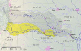
The Beaver River is an intermittent river, 280 miles (450 km) long, in western Oklahoma and northern Texas in the United States. It is a tributary of the North Canadian River, draining an area of 11,690 square miles (30,300 km2) in a watershed that extends to northeastern New Mexico and includes most of the Oklahoma Panhandle.

State Highway 149 is a state highway in Oklahoma. It runs 8.19 miles (13.18 km) in Harper County, from US-283 in Laverne to SH-46, seven miles (11 km) north of May.
Sweetwater Creek is a stream in the Texas Panhandle and western Oklahoma. It is a tributary to the North Fork of the Red River.
K-2 is a 61.516-mile-long (99.000 km) state highway in the south-central portion of the U.S. state of Kansas. Its southern terminus is at an intersection with U.S. Route 281 (US-281) east of Hardtner and its northern terminus is at an intersection with K-42 west of the town of Viola. Along the way K-2 passes through the cities of Kiowa, Hazelton, Anthony and Harper. Between the latter two, it has an overlap with US-160.
Protection Township is a township in Comanche County, Kansas, United States. As of the 2000 census, its population was 734.
Carrizo Creek is a 145-mile-long (233 km) river in New Mexico and Texas. It is a tributary of Rita Blanca Creek, itself a tributary of the Canadian River. Via the Arkansas and Mississippi rivers, water from Carrizo Creek eventually reaches the Gulf of Mexico. It is sometimes also known as the Carrizo River.

The North Fork Red River, sometimes called simply the "North Fork", is a tributary of the Red River of the South about 271 mi (436 km) long, heading along the eastern Caprock Escarpment of the Llano Estacado about 11.4 mi (18.3 km) southwest of Pampa, Texas. Rising in Gray County, Texas, it terminates at the confluence with Prairie Dog Town Fork of the Red River at the Texas-Oklahoma border.
Cache Creek is a small creek in Cotton County, Oklahoma and a tributary of the Red River. Cache Creek has a distance of 5.5 miles (8.85 km) from the Red River to the East Cache Creek and West Cache Creek basin. The East Cache Creek and West Cache Creek confluence is located 6 miles (9.75 km) southwest of Temple, Oklahoma.
South Carrizo Creek forms either just west of the Oklahoma line in New Mexico, or east inside Oklahoma to the northwest of Wheeless, Oklahoma. It is intermittent. It travels generally northeast through Black Mesa State Park where it is impounded to form Lake Carl Etling, before being joined by Willow Creek and continuing northeast to flow into the Cimarron River.
West Carrizo Creek forms in Las Animas County, Colorado west-southwest of Kim, Colorado and flows generally east. It connects with East Carrizo Creek, which forms in Colorado north of Mt. Carrizo and east of Kim, and which flows generally southeast before turning south, to form North Carrizo Creek at a point about six miles north of the Preston Monument, the tripoint of Colorado, Oklahoma and New Mexico.
Carrizo Creek forms in Arizona north of Cibecue, before flowing generally southeast, being joined by Corduroy Creek around the town of Carrizo, and continuing generally south to join the Salt River.
Corrumpa Creek is a watercourse in New Mexico and Oklahoma. It originates at Weatherly Lake, located 9 miles east-southeast of Des Moines in Union County, New Mexico. It results from the South Branch Corrumpa Creek, which originates south-southwest of Des Moines and travels generally east, and the North Branch Corrumpa Creek, which originates southwest of Des Moines but passes northeast through the town before continuing generally east-southeast, having their confluence at Weatherly Lake. From that location, Corrumpa Creek meanders in every direction but generally east before turning southeast near the Oklahoma border. It continues into Oklahoma where, at the point where it is joined by Seneca Creek about 4.5 miles northwest of Felt, Oklahoma, it officially becomes the Beaver River.
Seneca Creek, also known as Cienequilla Creek, is a watercourse in New Mexico and Oklahoma. Running south of, and roughly parallel to, Corrumpa Creek, it originates south-southeast of Des Moines, New Mexico and east-northeast of Grenville, and travels generally east, eventually crossing into Oklahoma. Where it finally joins Corrumpa Creek about 4.5 miles northwest of Felt, Oklahoma, the combined stream becomes the Beaver River.
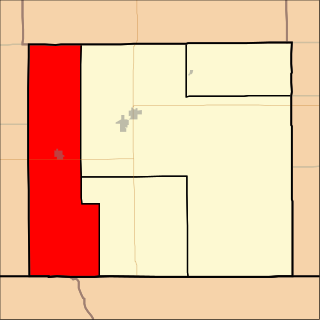
Spring Creek is a tributary of the Beaver River in Harper County, Oklahoma, south of Laverne. It is formed by the joinder of two other streams, known as the North Fork Spring Creek and the South Fork Spring Creek. Both the North Fork and the South Fork originate southwest of Laverne, just inside Beaver County. The North Fork heads northeasterly over the western Harper County line, whereas the South Fork heads east over the western border of Ellis County before taking a more north-northwesterly direction and crossing over the southern border of Harper County. The forks meet south-southwest of Laverne and just north of US-412/US-270. Spring Creek then travels generally northeast. Maps typically show the creek terminating southeast of Laverne short of reaching the Beaver, but the watershed extends all the way to the river.
Kiowa Creek is a stream in Comanche County, Kansas. Its watershed includes multiple other streams. West Kiowa Creek forms in northeast Clark County, Kansas, and flows generally southeast, passing through the southwestern corner of Kiowa County, Kansas, where it is joined by Turkey Creek and Little Turkey Creek. It continues into Comanche County, where it is joined by Middle Kiowa Creek, a southerly-flowing stream originating in Kiowa County to the north. The combined stream flows generally south, and becomes simply Kiowa Creek at some point. It is later joined by East Kiowa Creek, also a southerly-flowing stream originating in Kiowa County to the north, and one having its own tributary, Wiggins Creek. Kiowa Creek continues generally south, and travels along the eastern border of the town of Protection, Kansas, before becoming a tributary of Cavalry Creek to the southeast of Protection. Cavalry Creeks feeds into Bluff Creek, which eventually becomes a tributary of the Cimarron River before that watercourse enters Oklahoma.
Lake Evans Chambers, also known as Evans Chambers Lake, is a fishing lake constructed by the Oklahoma Department of Wildlife Conservation in 1965 in Beaver County, Oklahoma, 18 miles west of Laverne. The lake has 80 acres of surface area, and 2.8 miles of shoreline. The lake has a boat ramp, and anglers may find Largemouth Bass, White Bass, White Crappie, Black Crappie, Bluegill Sunfish, Channel Catfish, and Walleye.
Lake Frederick is a reservoir in Tillman County, Oklahoma. It is located about 15 miles northeast of the town of Frederick, which owns it. It was constructed in 1974 for flood control and to provide a water supply. It has a total surface area of 878 acres, and a total volume of 9,663 acre-feet. It has about 18 miles of shoreline.
References
- 1 2 3 4 "Kiowa Creek". Texas State Historical Association. Retrieved August 20, 2021.
- 1 2 3 "Kiowa Creek". Natural Atlas. Retrieved August 20, 2021.
- ↑ "Kiowa Creek, Texas". Google Maps. Retrieved August 21, 2021.
- ↑ "Camp Creek, Oklahoma". Google Maps. Retrieved August 21, 2021.
- 1 2 "Harper County, Oklahoma". Google Maps. Retrieved August 21, 2021.
- ↑ "Beaver River, Oklahoma". Google Maps. Retrieved August 21, 2021.
- ↑ "Kiowa Creek, Creek in Colorado". Natural Atlas. Retrieved August 20, 2021.
- ↑ "Kiowa Creek, Creek in Nebraska". Natural Atlas. Retrieved August 20, 2021.
| | This article related to a river in Texas is a stub. You can help Wikipedia by expanding it. |