
The San Francisco Municipal Railway (SF Muni or Muni), is the public transit system for the City and County of San Francisco. It operates a system of bus routes, the Muni Metro light rail system, three historic cable car lines, and two historic streetcar lines. Previously an independent agency, the San Francisco Municipal Railway merged with two other agencies in 1999 to become the San Francisco Municipal Transportation Agency (SFMTA). In 2018, Muni served 46.7 square miles (121 km2) with an operating budget of about $1.2 billion. Muni is the seventh-highest-ridership transit system in the United States, with 114,721,200 rides in 2022, and the second-highest in California after the Los Angeles County Metropolitan Transportation Authority.

The N Judah is a hybrid light rail/streetcar line of the Muni Metro system in San Francisco, California. The line is named after Judah Street that it runs along for much of its length, named after railroad engineer Theodore Judah. It links downtown San Francisco to the Cole Valley and Sunset neighborhoods. It is the busiest line in the Muni Metro system, serving an average of 41,439 weekday passengers in 2013. It was one of San Francisco's streetcar lines, beginning operation in 1928, and was partially converted to modern light-rail operation with the opening of the Muni Metro system in 1980. While many streetcar lines were converted to bus lines after World War II, the N Judah remained a streetcar line due to its use of the Sunset Tunnel.

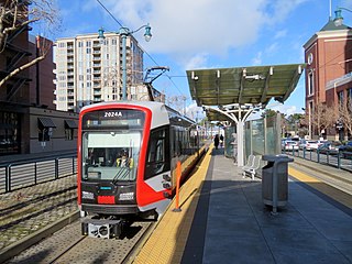
The T Third Street is a Muni Metro light rail line in San Francisco, California. It runs along the east side of San Francisco from Sunnydale to Chinatown, traveling in the median of Third Street for most of its length before entering the Central Subway as it approaches downtown. The line serves 22 stations, all of which are accessible. Most of the surface portion of the line runs in dedicated median lanes, though two portions operate in mixed traffic.
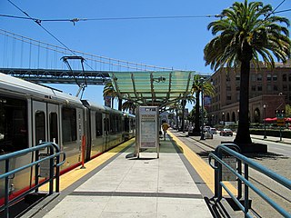
The Embarcadero and Folsom station is a Muni Metro light rail station located in the median of The Embarcadero between Folsom Street and Harrison Street in the Rincon Hill area of San Francisco, California. Muni Metro trains use a high-level island platform, while historic streetcars use a pair of side platforms at the southeast end of the station next to the Harrison Street grade crossing.
2nd and King station is a Muni Metro light rail station located in the median of King Street near Second Street in the China Basin neighborhood of San Francisco, California. It is adjacent to Oracle Park. Muni Metro trains use a high-level island platform, while historic streetcars use a pair of side platforms just to the south.
Mission Rock station is a light rail station on the Muni Metro T Third Street line, located in the median of Third Street at Mission Rock Street in the Mission Bay neighborhood of San Francisco, California. The station opened with the T Third Street line on January 13, 2007. It has two side platforms; the northbound platform is north of Mission Rock Street, and the southbound platform south of Mission Rock Street, which allows trains to pass through the intersection before stopping at the station.

UCSF Medical Center station is a light rail station on the Muni Metro T Third Street line, located in the median of Third Street at Mariposa Street in the Mission Bay neighborhood of San Francisco, California. The station serves the UCSF Medical Center and the larger UCSF Mission Bay campus. The station opened with the T Third Street line on January 13, 2007. It has two side platforms; the northbound platform is north of Mariposa Street, and the southbound platform south of Mariposa Street, which allows trains to pass through the intersection before stopping at the station.

20th Street station is a light rail station on the Muni Metro T Third Street line in the Dogpatch neighborhood of San Francisco, California. The station opened with the T Third Street line on January 13, 2007. It has two side platforms; the northbound platform is north of 20th Street, and the southbound platform south of 20th Street, so that trains can pass through the intersection before the station stop.

Marin Street station is a light rail station on the Muni Metro T Third Street line, located in the median of 3rd Street one block south of Cesar Chavez Street in the Bayview neighborhood of San Francisco, California. The station opened with the T Third Street line on April 7, 2007. It has two side platforms; the northbound platform is south of South Street, and the southbound platform north of Marin Street.

Evans station is a light rail station on the Muni Metro T Third Street line, located in the median of 3rd Street at Evans Avenue in the Bayview neighborhood of San Francisco, California. The station opened with the T Third Street line on January 13, 2007. It has two side platforms; the northbound platform is north of Evans Avenue, and the southbound platform south of Evans Avenue so that trains can pass through the intersection before the station stop.
Hudson/Innes station is a light rail station on the Muni Metro T Third Street line in the Bayview neighborhood of San Francisco, California. The station opened with the T Third Street line on January 13, 2007. It has a single island platform located in the median of Third Street between Hudson Avenue and Innes Avenue, with access from crosswalks at both streets.

Oakdale/Palou station is a light rail station on the Muni Metro T Third Street line in the Bayview neighborhood of San Francisco, California. The station opened with the T Third Street line on January 13, 2007. It has a single island platform located in the median of Third Street between Oakdale Avenue and Palou Avenue, with access from crosswalks at both streets.

Revere/Shafter station is a light rail station on the Muni Metro T Third Street line in the Bayview neighborhood of San Francisco, California. The station opened with the T Third Street line on January 13, 2007. It has a single island platform located in the median of Third Street between Revere Avenue and Shafter Avenue, with access from crosswalks at both streets.

Williams station is a light rail station of the San Francisco Municipal Railway's Muni Metro system located in the median of Third Street at Williams and Van Dyke Avenues in Bayview, San Francisco, California, United States. The station opened along with the T Third Street line on January 13, 2007. It has two side platforms; the northbound platform is north of Williams Avenue, and the southbound platform south of Williams Avenue, so that trains can pass through the intersection before the station stop. A wye for trains to reverse directions is located two blocks south at Armstrong Avenue, allowing Williams station to be the terminus of short turn trains when necessary.
Carroll station is a light rail station on the Muni Metro T Third Street line, located in the median of Third Street in the Bayview neighborhood of San Francisco, California. The station opened with the T Third Street line on January 13, 2007. It has two side platforms; the northbound platform is north of Carroll Avenue, and the southbound platform south of Carroll Avenue, so that trains can pass through the intersection before the station stop.

Gilman/Paul station is a light rail station on the Muni Metro T Third Street line, located in the median of Third Street in the Bayview neighborhood of San Francisco, California. The station opened with the T Third Street line on January 13, 2007. It has two side platforms; the northbound platform is north of Gilman Avenue/Paul Avenue, and the southbound platform to the south, so that trains can pass through the intersection before the station stop.

Le Conte station is a light rail station on the Muni Metro T Third Street line in the Bayview neighborhood of San Francisco, California. The station opened with the T Third Street line on January 13, 2007. It has a single island platform located in the median of Third Street south of Le Conte Avenue. The station is located in an open cut between the travel lanes of Third Street, which rise south of Le Conte Avenue to pass over Candlestick Hill and the Bayshore Freeway. South of the station, the line also rises to pass over the hill and highway.
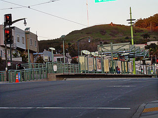
Arleta station is a light rail station on the Muni Metro T Third Street line in the Visitacion Valley neighborhood of San Francisco, California on the south slope of Candlestick Hill. The station opened with the T Third Street line on January 13, 2007. It has a single island platform located in the median of Bayshore Boulevard between Arleta Avenue and Blanken Avenue, with access from crosswalks at both streets.

Sunnydale station is a light rail station on the Muni Metro T Third Street line, located in the median of Bayshore Boulevard in the Visitacion Valley neighborhood of San Francisco, California. The station opened as the terminus of the T Third Street line on April 7, 2007. It has a single island platform north of Sunnydale Avenue. Tail tracks and a crossover for trains to reverse direction are located south of Sunnydale Avenue.

Taraval and Sunset is a light rail stop on the Muni Metro L Taraval line, located in the Parkside neighborhood of San Francisco, California. The station opened with the second section of the L Taraval line on January 14, 1923.

