
Polyarny is a town and the administrative center of the closed administrative-territorial formation of Alexandrovsk in Murmansk Oblast, Russia, situated on the outermost western side of the Kola Bay. Population: 17,293 (2010 Census); 18,552 (2002 Census); 27,635 (1989 Census).
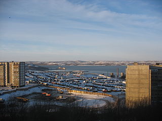
Severomorsk, previously known as Vayenga (Ваенга), is a closed town in Murmansk Oblast, Russia. Severomorsk is the main administrative base of the Russian Northern Fleet. The town is located on the coast of the Barents Sea along the Kola Bay 25 kilometers (16 mi) northeast of Murmansk, the administrative centre of the oblast, to which it is connected by railway and a motorway.

Monchegorsk is a town in Murmansk Oblast, Russia, located on the Kola Peninsula, 145 kilometers (90 mi) south of Murmansk, the administrative center of the oblast. Population: 45,361 (2010 Census); 52,242 ; 68,652.
Murmansk Oblast is a federal subject of Russia, which is located in the northwestern part of the country, occupying mostly the Kola Peninsula. The oblast itself was established on May 28, 1938, but some kind of administrative organization of the territory existed here since at least the 13th century. As of the 2002 Census, Russians account for the majority of the oblast's population, with the indigenous Sami constituting only a 0.20% minority (1,769 people).
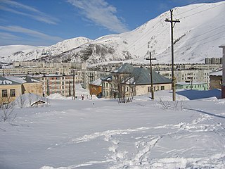
Kirovsk, known as Khibinogorsk (Хибиного́рск) until 1934, is a town in Murmansk Oblast, Russia, located at the spurs of the Khibiny Mountains on the shores of the Lake Bolshoy Vudyavr, 175 kilometers (109 mi) south of Murmansk. Population: 28,625 (2010 Census).
Pechengsky District is an administrative district (raion), one of the six in Murmansk Oblast, Russia. As a municipal division, it is incorporated as Pechengsky Municipal District. It is located in the northwest of the oblast, on the coast of the Barents Sea and borders Finland in the south and southwest and Norway in the west, northwest, and north. The area of the district is 8,662.22 square kilometers (3,344.50 sq mi). Its administrative center is the urban locality of Nikel. Population: 38,920 (2010 Census); 46,404 (2002 Census); 59,495 (1989 Census). The population of Nikel accounts for 32.8% of the district's total population.

Ura-Guba, also known as Ura (Ура), is a rural locality in Kolsky District of Murmansk Oblast, Russia, located beyond the Arctic Circle at a height of 1 meter above sea level. Population: 517.

Kolsky District is an administrative district (raion), one of the six in Murmansk Oblast, Russia. As a municipal division, it is incorporated as Kolsky Municipal District. It is located in the northwest of the oblast, partially lies on the Kola Peninsula, and borders with the Barents Sea in the north and Finland in the west. The area of the district is 27,600 square kilometers (10,700 sq mi). Its administrative center is the town of Kola. Population: 44,670 (2010 Census); 51,125 (2002 Census); 73,555 (1989 Census). The population of Kola accounts for 23.4% of the district's total population.
Murmansk Krai was an informal name used in the early Russian SFSR to refer to the territory roughly corresponding to modern Murmansk Oblast. At various times, the term referred to the territory which included Alexandrovsky and Kemsky Uyezds of Arkhangelsk Governorate and some parts of Olonets Governorate.
Kolsko-Loparskaya Volost was at various times an administrative division of Kemsky, Kolsky, and Alexandrovsky Uyezds of Arkhangelsk Governorate of the Russian Empire, and then of Murmansk Governorate of the Russian SFSR. It existed in 1868–1927.
Lovozerskaya Volost or Loparskaya Volost was an administrative division of Alexandrovsky Uyezd of Arkhangelsk Governorate and later of Murmansk Governorate of the Russian SFSR.
Novozerskaya Volost was an administrative division of Alexandrovsky (Murmansky) Uyezd of Arkhangelsk Governorate and then of Murmansk Governorate of the Russian SFSR.
Teriberskaya Volost was an administrative division of Alexandrovsky Uyezd of Arkhangelsk Governorate, Russian Empire, and then of Murmansk Governorate of the Russian SFSR.
Monchegorsky District was an administrative division of Murmansk Okrug of Leningrad Oblast, and later of Murmansk Oblast of the Russian SFSR, Soviet Union, which existed in 1938–1949.
Kirovsky District was an administrative division of Murmansk Okrug of Leningrad Oblast, and later a district of Murmansk Oblast, of the Russian SFSR, Soviet Union, which existed in 1935–1954.
Polyarny District was an administrative division of Murmansk Okrug of Leningrad Oblast of the Russian SFSR, Soviet Union, and later of Murmansk Oblast, which existed in 1927–1960.
Teribersky District, also known as Severomorsky District was an administrative division of Murmansk Okrug of Leningrad Oblast of the Russian SFSR, Soviet Union, and later of Murmansk Oblast, which existed in 1927–1963.
Saamsky District was an administrative division of Murmansk Okrug of Leningrad Oblast, and later of Murmansk Oblast, of the Russian SFSR, Soviet Union, which existed in 1927–1963.
Oktyabrsky Administrative Okrug is a territorial division of the City of Murmansk in Murmansk Oblast, Russia. Population: 95,569 (2010 Census); 104,831 (2002 Census); 144,431 (1989 Census).
Leninsky Administrative Okrug is a territorial division of the City of Murmansk in Murmansk Oblast, Russia. Population: 90,331 (2010 Census); 97,755 (2002 Census); 147,235 (1989 Census).

