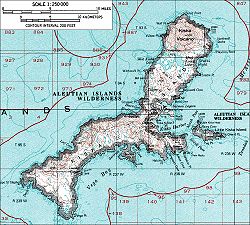
Kiska Harbor is an inlet on the east coast of the island of Kiska in the Aleutian Islands in Alaska. [1]
An inlet is an indentation of a shoreline, usually long and narrow, such as a small bay or arm, that often leads to an enclosed body of salt water, such as a sound, bay, lagoon, or marsh.
The Aleutian Islands, also called the Aleut Islands or Aleutic Islands and known before 1867 as the Catherine Archipelago, are a chain of 14 large volcanic islands and 55 smaller ones belonging to both the U.S. state of Alaska and the Russian federal subject of Kamchatka Krai. They form part of the Aleutian Arc in the Northern Pacific Ocean, occupying an area of 6,821 sq mi (17,666 km2) and extending about 1,200 mi (1,900 km) westward from the Alaska Peninsula toward the Kamchatka Peninsula in Russia, and mark a dividing line between the Bering Sea to the north and the Pacific Ocean to the south. Crossing longitude 180°, at which point east and west longitude end, the archipelago contains both the westernmost part of the United States by longitude and the easternmost by longitude. The westernmost U.S. island in real terms, however, is Attu Island, west of which runs the International Date Line. While nearly all the archipelago is part of Alaska and is usually considered as being in the "Alaskan Bush", at the extreme western end, the small, geologically related Commander Islands belong to Russia.
Alaska is a U.S. state in the northwest extremity of North America, just across the Bering Strait from Asia. The Canadian province of British Columbia and territory of Yukon border the state to the east and southeast. Its most extreme western part is Attu Island, and it has a maritime border with Russia to the west across the Bering Strait. To the north are the Chukchi and Beaufort seas—southern parts of the Arctic Ocean. The Pacific Ocean lies to the south and southwest. It is the largest U.S. state by area and the seventh largest subnational division in the world. In addition, it is the 3rd least populous and the most sparsely populated of the 50 United States; nevertheless, it is by far the most populous territory located mostly north of the 60th parallel in North America: its population—estimated at 738,432 by the United States Census Bureau in 2015— is more than quadruple the combined populations of Northern Canada and Greenland. Approximately half of Alaska's residents live within the Anchorage metropolitan area. Alaska's economy is dominated by the fishing, natural gas, and oil industries, resources which it has in abundance. Military bases and tourism are also a significant part of the economy.
Kiska Harbor is bounded by North Head on the north and by South Head on the south. Little Kiska Island lies off the coast of Kiska Island immediately east of Kiska Harbor. [2]
Little Kiska Island is an island off east coast of the island of Kiska in the Aleutian Islands in Alaska. It lies immediately east of Kiska Harbor.
During their occupation of Kiska Island from June 1942 to July 1943 during World War II, the Japanese used Kiska Harbor as a naval base.
World War II, also known as the Second World War, was a global war that lasted from 1939 to 1945. The vast majority of the world's countries—including all the great powers—eventually formed two opposing military alliances: the Allies and the Axis. A state of total war emerged, directly involving more than 100 million people from over 30 countries. The major participants threw their entire economic, industrial, and scientific capabilities behind the war effort, blurring the distinction between civilian and military resources. World War II was the deadliest conflict in human history, marked by 50 to 85 million fatalities, most of whom were civilians in the Soviet Union and China. It included massacres, the genocide of the Holocaust, strategic bombing, premeditated death from starvation and disease, and the only use of nuclear weapons in war.
Japan is an island country in East Asia. Located in the Pacific Ocean, it lies off the eastern coast of the Asian continent and stretches from the Sea of Okhotsk in the north to the East China Sea and the Philippine Sea in the south.
A naval base, navy base, or military port is a military base, where warships and naval ships are docked when they have no mission at sea or want to restock. Usually ships may also perform some minor repairs. Some naval bases are temporary homes to aircraft that usually stay on the ships but are undergoing maintenance while the ship is in port.
Ikazuchi was the twenty-third Fubuki-class destroyer, or the third Akatsuki class, built for the Imperial Japanese Navy in the inter-war period. When introduced into service, these ships were the most powerful destroyers in the world. They remained formidable weapons systems well into the Pacific War.
USS Grunion (SS-216) was a Gato-class submarine that was sunk at Kiska, Alaska, during World War II. She was the only ship of the United States Navy to be named for the grunion.
USS S-28 (SS-133) was a S-class submarine of the United States Navy. A diesel submarine, she served during World War II during which she accounted for the sinking of one Japanese ship. Her keel was laid down on 16 April 1919 by the Bethlehem Shipbuilding Corporation's Fore River Shipyard in Quincy, Massachusetts. She was launched on 20 September 1922, sponsored by Mrs. William R. Monroe, and commissioned on 13 December 1923, Lieutenant Kemp C. Christian in command. She was lost at sea with all hands in July 1944. The remains of the sub were found in 2017 at a depth of 8,500 feet (2,600 m) off the coast of Oahu.
This is a list of aviation-related events from 1943:
USS S-18 (SS-123) was a first-group S-class submarine of the United States Navy. Her keel was laid down on 15 August 1918 by the Bethlehem Shipbuilding Corporation's Fore River Shipyard in Quincy, Massachusetts. She was launched on 29 April 1920 sponsored by Miss Virginia Bell Johnson, and commissioned on 3 April 1924 with Lieutenant Elliot M. Senn in command.
Operation Cottage was a tactical maneuver which completed the Aleutian Islands campaign. On August 15, 1943, Allied military forces landed on Kiska Island, which had been occupied by Japanese forces since June 1942.
The Battle of Attu, which took place on 11–30 May 1943, was a battle fought between forces of the United States, aided by Canadian reconnaissance and fighter-bomber support, and Japan on Attu Island off the coast of the Territory of Alaska as part of the Aleutian Islands Campaign during the American Theater and the Pacific Theater. It was the only land battle of World War II fought on the continental United States.
The Japanese occupation of Kiska took place between 6 June 1942 and 28 July 1943 during the Aleutian Islands Campaign of the American Theater and the Pacific Theater of World War II. The Japanese occupied Kiska and nearby Attu Island in order to protect the northern flank of the Japanese Empire. Along with the Attu landing the same time, it was the first time that the continental United States was occupied by a foreign power since the War of 1812.
Constantine Harbor is an inlet on the eastern end of the north coast of the island of Amchitka in the Aleutian Islands in Alaska. It is near the site of an abandoned military airstrip.
Massacre Bay is an inlet on the southeast coast of the island of Attu in the Aleutian Islands in Alaska.
Holtz Bay is an inlet on the northeast coast of the island of Attu in the Aleutian Islands in Alaska.
Sarana Bay is an inlet on the east coast of the island of Attu in the Aleutian Islands in Alaska.
Sarana Valley is a valley in the mountains of northeastern Attu Island in the Aleutian Islands in Alaska.
Sarana Pass is a pass in the mountains of northeastern Attu Island in the Aleutian Islands in Alaska.
Chichagof Harbor is an inlet on the northeast coast of the island of Attu in the Aleutian Islands in Alaska. It is named after Russian Admiral and polar explorer Vasily Chichagov. It is the location of the Aleut village served by an American pastor and his wife. It was also where some heavy fighting took place during the recapture of the island from the Japanese during the Battle of Attu in World War II and afterwards was the site of Battery B 42nd Coast Artillery Battalion.
Amukta Pass is a wide strait between the Bering Sea and the North Pacific Ocean in the Aleutian Islands in Alaska. It lies between Amukta Island to the east and Seguam Island to the west.
Kagoshima Bay is a deep inlet on the coast of Japan.
Oyster Bay, also known as Oyster Bay Harbor, is an inlet of Long Island Sound on the north shore of Long Island in New York in the United States.
Nissan Maru was a Japanese cargo ship completed in 1939 owned by Nissan Kisen K.K. that was requestioned for service as an auxiliary collier and oiler by the Imperial Japanese Navy during World War II. She served with the 5th Fleet and was sunk by United States Army Air Forces bombers during the Japanese occupation of Kiska in the Aleutian Islands Campaign.
The International Standard Book Number (ISBN) is a numeric commercial book identifier which is intended to be unique. Publishers purchase ISBNs from an affiliate of the International ISBN Agency.
Coordinates: 51°58′01″N177°33′50″E / 51.96694°N 177.56389°E
A geographic coordinate system is a coordinate system that enables every location on Earth to be specified by a set of numbers, letters or symbols. The coordinates are often chosen such that one of the numbers represents a vertical position and two or three of the numbers represent a horizontal position; alternatively, a geographic position may be expressed in a combined three-dimensional Cartesian vector. A common choice of coordinates is latitude, longitude and elevation. To specify a location on a plane requires a map projection.
This article about a location in the Aleutians West Census Area, Alaska is a stub. You can help Wikipedia by expanding it. |