Kjerulføya

Last updated

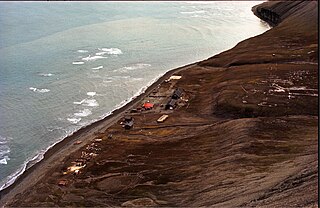
Kjerulføya is an island north of Nordaustlandet in Svalbard, Norway. It is named for Theodor Kjerulf. [1] The island is located within Nordaust-Svalbard Nature Reserve.

Nordaustlandet island in the Svalbard archipelago

Nordaustlandet is the second-largest island in the archipelago of Svalbard, Norway, with an area of 14,443 square kilometres (5,576 sq mi). It lies north east of Spitsbergen, separated by Hinlopen Strait. Much of Nordaustlandet lies under large ice caps, mainly Austfonna and Vestfonna, the remaining parts of the north being tundra inhabited by reindeer and walruses. The island is uninhabited and lies entirely within Nordaust-Svalbard Nature Reserve.

Svalbard Archipelago in the Arctic Ocean

Svalbard is a Norwegian archipelago in the Arctic Ocean. Situated north of mainland Europe, it is about midway between continental Norway and the North Pole. The islands of the group range from 74° to 81° north latitude, and from 10° to 35° east longitude. The largest island is Spitsbergen, followed by Nordaustlandet and Edgeøya. Administratively, the archipelago is not part of any Norwegian county, but forms an unincorporated area administered by a governor appointed by the Norwegian government. Since 2002, Svalbard's main settlement, Longyearbyen, has had an elected local government, somewhat similar to mainland municipalities. Other settlements include the Russian mining community of Barentsburg, the research station of Ny-Ålesund, and the mining outpost of Sveagruva. Ny-Ålesund is the northernmost settlement in the world with a permanent civilian population. Other settlements are farther north, but are populated only by rotating groups of researchers.

Norway constitutional monarchy in Northern Europe

Norway, officially the Kingdom of Norway, is a Nordic country in Northern Europe whose territory comprises the western and northernmost portion of the Scandinavian Peninsula; the remote island of Jan Mayen and the archipelago of Svalbard are also part of the Kingdom of Norway. The Antarctic Peter I Island and the sub-Antarctic Bouvet Island are dependent territories and thus not considered part of the kingdom. Norway also lays claim to a section of Antarctica known as Queen Maud Land.

In the film Orion's Belt, Kjerulfsøya is the location of the Soviet bearing station. [2]

<i>Orions Belt</i> (film) 1985 Norwegian film

Orion's Belt is a 1985 Norwegian dual-language, political action thriller film, directed by Ola Solum and Tristan DeVere Cole. It is based on Jon Michelet's 1977 novel by the same name. The film follows three Svalbard-based shabby seamen, played by Helge Jordal, Sverre Anker Ousdal and Hans Ola Sørlie, who discover a Soviet bearing station. They are subsequently targets of Soviet liquidation and American interrogation in an attempt to quiet them and retain the political status quo. The Cold War topics were a critique of the Norwegian policy of allowing a Soviet presence on Svalbard.

Related Research Articles

Svalbard and Jan Mayen Two parts of Norway under separate jurisdictions

Svalbard and Jan Mayen is a statistical designation defined by ISO 3166-1 for a collective grouping of two remote jurisdictions of Norway—Svalbard and Jan Mayen. While the two are combined for the purposes of the International Organization for Standardization (ISO) category, they are not administratively related. This has further resulted in the country code top-level domain .sj being issued for Svalbard and Jan Mayen, and ISO 3166-2:SJ. The United Nations Statistics Division also uses this code, but has named it Svalbard and Jan Mayen Islands.

Sjuøyane archipelago

Sjuøyane is the northernmost part of the Svalbard archipelago north of Norway, and some 20 km north of the major island Nordaustlandet.

Rossøya island in Norway

Rossøya, sometimes referred to as Ross Island in English, is an island located in the Arctic Ocean. It is a part of Sjuøyane, a group of islands in the Svalbard archipelago, some 20 km north of the coast of Nordaustlandet, Svalbard in Arctic Norway. Rossøya is located 100 m north-northwest of the somewhat larger island Vesle Tavleøya. The northern point of Rossøya, at 80° 49′ 44.41″ North, is the northernmost point in Svalbard, and thereby also in the Kingdom of Norway. The distance to the North Pole is 1024.3 kilometers, to Nordkapp on the Norwegian mainland 1084 km and to Pysen, off the southern tip of mainland Norway, 2580 km.

Phippsøya island in Norway

Phippsøya is the largest island in Sjuøyane, an archipelago north of Nordaustlandet, Svalbard in Arctic Norway. It is located some 22 km north of Nordkapp on Svaldbard proper and 8.5 km south of Rossøya, the northernmost island of the Svalbard archipelago. Phippsøya is separated from Parryøya to the south by the 1.3 km wide Straumporten sound, from Martensøya to the southeast by the 1.1 km wide Trollsundet and from Tavleøya to the northwest by the 1 km wide Marmorsundet.

Novelists, screenwriters and filmmakers have set their works in Svalbard, an archipelago in the Arctic which constitutes the northernmost part of Norway. Fictional works about Svalbard often make reference to its Arctic climate, the isolation of the archipelago and the natural beauty of its vast glaciers, mountains and fjords.

Karl XII-øya island in Norway

Karl XII-øya is an island north of the island of Nordaustlandet in Svalbard, Norway. Except for Sjuøyane, Karl XII-øya is the northernmost part of Svalbard, and thus also Norway.

Hopen Radio

Hopen Radio is a coast radio station and the only settlement on the island of Hopen in Svalbard, Norway. It is located between Kollerfjellet and Werenskioldfjellet.

Glenhalvøya is a peninsula in Orvin Land at Nordaustlandet, Svalbard, between Finn Malmgren Fjord and Duvefjorden. It is named after Arctic explorer Alexander Richard Glen. The island of Søre Repøya is separated from the peninsula by the strait of Gilessundet.

Murchisonfjorden is a fjord in Gustav V Land at Nordaustlandet, Svalbard. The fjord cuts eastwards from Hinlopen Strait into Nordaustlandet. It has steep coasts and numerous islands. Murchisonfjorden is named after British geologist Roderick Murchison.

Andréeneset is headland at the southwestern point of the island of Kvitøya in the Svalbard archipelago. It is named after engineer and Arctic explorer Salomon August Andrée.

Storøya is an island in the Svalbard archipelago. It is located east of Nordaustlandet, separated from Nordaustlandet by the strait of Storøysundet. The southern part of the island is covered by the glacier Storøyjøkulen.

Sørodden is a headland and the most southern point of the island Storøya in the Svalbard archipelago, east of Nordaustlandet. The headland is also the southern part of the glacier Storøyjøkulen.

Storøysundet is a strait in the Svalbard archipelago. It separates the island of Storøya to the east from Nordaustlandet to the west.

Sabinebukta is a bay at the northern side of Nordaustlandet, Svalbard. The bay is split into Vestre Sabinevågen and Austre Sabinevågen. The Sabine Islands are located in the outer part of the bay. The bay is named after Arctic explorer Edward Sabine.

Scoresbyøya is an island in the Svalbard archipelago, north of Nordaustlandet. It has an area of about 6 km², and is located in Nordenskiöldbukta, outside the bay of Sabinebukta. The island is named after Arctic explorer William Scoresby. The southern part of the island is dominated by a large lagoon and narrow sand banks.

Bergströmodden is a headland in Orvin Land at Nordaustlandet, Svalbard. It is located north of the mountain Boydfjellet, at the mouth of Finn Malmgren Fjord, east of Alpini Island. The headland is named after Swedish politician Axel Bergström.

Repøyane is the name of two islands off Orvin Land at Nordaustlandet, Svalbard. The two islands, Nordre and Søre Repøya, are located at the northern side of Glenhalvøya, at the mouth of Duvefjorden. The two islands are separated by the Poortsundet sound, and Gilessundet separates Søre Repøya from Glenhalvøya.

Søre Repøya is the largest and southern island of the two Repøyane, off Orvin Land at Nordaustlandet, Svalbard. The island rises to a plateau of up to 240 m.a.s.l. It is separated from Glenhalvøya by the sound Gilessundet, and from Nordre Repøya by the sound Poortsundet. The island is named after Dutch whaler Outger Rep van Ootzaan.

Nordre Repøya is the northern island of the two Repøyane, off Orvin Land at Nordaustlandet, Svalbard. The island rises to a height of 230 m.a.s.l. It is separated from Søre Repøya by the sound Poortsundet. The island is named after Dutch whaler and map publisher Outger Rep van Oostzaan.

References

  1. "Kjerulføya". Norwegian Polar Institute . Retrieved 18 March 2012.[ permanent dead link ]
  2. Skagen, Sølvi (2005). Fra idé til film: Orions belte (in Norwegian). Vett & Viten. p. 106. ISBN   82-412-0540-6.

Coordinates: 80°14.2′N25°40.4′E / 80.2367°N 25.6733°E / 80.2367; 25.6733

Geographic coordinate system Coordinate system

A geographic coordinate system is a coordinate system that enables every location on Earth to be specified by a set of numbers, letters or symbols. The coordinates are often chosen such that one of the numbers represents a vertical position and two or three of the numbers represent a horizontal position; alternatively, a geographic position may be expressed in a combined three-dimensional Cartesian vector. A common choice of coordinates is latitude, longitude and elevation. To specify a location on a plane requires a map projection.