
Santa Barbara County, California, officially the County of Santa Barbara, is located in Southern California. As of the 2010 census, the population was 423,895. The county seat is Santa Barbara, and the largest city is Santa Maria.
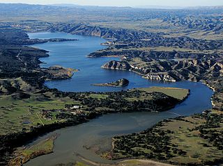
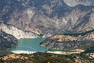
Cachuma Lake is a reservoir in the Santa Ynez Valley of central Santa Barbara County, California on the Santa Ynez River adjoining the north side of California State Route 154. The artificial lake was created by the construction of Bradbury Dam, a 201 ft (61 m) earth-fill structure built by the U.S. Bureau of Reclamation in 1953. Its surface area covers 3,100 acres (1,300 ha), with a maximum design capacity of 205,000 acre⋅ft (253,000,000 m3), but it is currently limited to 188,000 acre⋅ft (232,000,000 m3) due to sediment accumulation. As of May 23, 2019, it is at 80.8% of capacity.

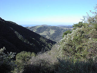
The Santa Ynez Mountains are a portion of the Transverse Ranges, part of the Pacific Coast Ranges of the west coast of North America. It is the westernmost range in the Transverse Ranges.
Gaviota State Park is a state park of California, USA. It is located in southern Santa Barbara County, California, about 33 miles (53 km) west of the city of Santa Barbara. One of three state parks along the Gaviota Coast, it extends from the Pacific coast to the crest of the Santa Ynez Mountains, and is adjacent to Los Padres National Forest. The 2,787-acre (1,128 ha) park was established in 1953.
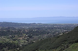
Noleta is an unofficial name used to designate the unincorporated urban area between Goleta and Santa Barbara in California, United States. It is bounded on the east by Santa Barbara and Hope Ranch, on the west by Goleta, on the north by the Santa Ynez Mountains and on the south by the Pacific Ocean, and largely includes the zip codes 93105, 93110, and 93111. Approximately 30,000 people live in the area.
Los Padres National Forest is a United States national forest in southern and central California. Administered by the United States Forest Service, Los Padres includes most of the mountainous land along the California coast from Ventura to Monterey, extending inland. Elevations range from sea level to 8,847 feet (2,697 m).

The Santa Ynez River is one of the largest rivers on the Central Coast of California. It is 92 miles (148 km) long, flowing from east to west through the Santa Ynez Valley, reaching the Pacific Ocean at Surf, near Vandenberg Air Force Base and the city of Lompoc.

Ramapo Mountain State Forest is a 4,200 acres (17 km2) state forest in Bergen and Passaic Counties in New Jersey. The park is operated and maintained by the New Jersey Division of Parks and Forestry.

The Douglas Family Preserve is a public park in Santa Barbara, California. The Preserve is located on the mesa above Arroyo Burro Beach. The property spans 70 acres (280,000 m2) of undeveloped ocean-front land, and represents the largest area of coastal open space within the city limits of Santa Barbara.

The Dick Smith Wilderness is a wilderness area in the mountains of eastern Santa Barbara County, California, United States, with a portion in Ventura County. It is completely contained within the Los Padres National Forest, and is northeast of the city of Santa Barbara and north of the city of Ojai. It is most easily accessible from two trailheads off State Route 33, which runs north from Ojai. It is adjacent to the large San Rafael Wilderness on the west and the Matilija Wilderness on the south. Across Highway 33 to the east, and also in the Los Padres National Forest, is the large Sespe Wilderness.

Mar Y Cel or, more correctly, Mar i Cel is an open space preserve conserved by the Land Trust for Santa Barbara County, in Santa Barbara County, California, USA. Located in the Santa Ynez Mountains foothills above Montecito, Mar Y Cel is a 350-acre (1.4 km2) estate. It includes the notable "Tea Gardens", as well as the West Fork of Cold Springs Trail, a well used hiking trail.

Laurel Springs Ranch is a 160-acre (0.65 km2) ranch located on a ridgetop in the Santa Ynez Mountain range northwest of Santa Barbara, California, between the Painted Cave community and the intersection of Painted Cave road with East Camino Cielo Road in the Los Padres National Forest.

Shalawa Meadow is a 3-acre (0.012 km2) seaside meadow used in ancient times as a burial site by the Chumash people, adjoining a once large Chumash community about 5 miles east of Santa Barbara, California in the community of Montecito.

Painted Cave is an unincorporated community of Santa Barbara County located in the Santa Ynez Mountains and is so named due to its proximity to Painted Cave State Historic Park. It is primarily served by Camino Cielo Road and California State Route 154, which link the community both to the nearby Santa Ynez Valley and Santa Barbara, California. The community is made up of roughly 100 homesteads, plus many outlying settlements. Painted Cave is the highest and largest of the inholdings within the Santa Ynez Mountains, and commands an impressive view- on clear days, all seven of the Channel Islands can often be seen. The community is primarily composed of irregular lots, and does not, except in the center of the community, conform to any sort of grid. Painted Cave sits atop a rough plateau, and includes the large Laurel Springs Ranch. The local terrain is extremely hilly, and numerous homes along Rim and Lookout roads approach or even overhang sheer cliffs.
Gibraltar Dam is located on the Santa Ynez River, in southeastern Santa Barbara County, California, in the United States. Forming Gibraltar Reservoir, the dam is owned by the city of Santa Barbara. Originally constructed in 1920 and expanded in 1948, the dam and reservoir are located in a remote part of the Los Padres National Forest.
George Owen Knapp was a wealthy industrialist and philanthropist. He was the President of Peoples Gas Light and Coke Company in Chicago, Illinois by 1893. In 1894 he was a founder of the Union Calcium Carbide Company which he reformulated as Union Carbide in 1904. He was CEO and President, and the Board Chair of Union Carbide until 1933.
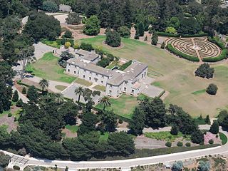
The Bellosguardo Foundation is a philanthropic organization and private foundation for the arts located at the oceanside estate in Santa Barbara, California, known as Bellosguardo, one of the empty mansions of the reclusive copper heiress Huguette Clark.

The Matilija Wilderness is a 29,207-acre (11,820 ha) wilderness area in Ventura and Santa Barbara Counties, Southern California. It is managed by the U.S. Forest Service, being situated within the Ojai Ranger District of the Los Padres National Forest. It is located adjacent to the Dick Smith Wilderness to the northwest and the Sespe Wilderness to the northeast, although it is much smaller than either one. The Matilija Wilderness was established in 1992 in part to protect California condor habitat.

The Matilija Fire was a major wildfire that burned nearly 220,000 acres (89,000 ha) in the Santa Barbara National Forest of Southern California, during the autumn of 1932. The fire is named for Matilija Creek, near the location from which it originated.

