
Cumberland County is a county in the U.S. state of Maine. As of the 2020 census, the population was 303,069, making it the most populous county in Maine. Its county seat is Portland. Cumberland County was founded in 1760 from a portion of York County, Province of Massachusetts Bay, and named for William, Duke of Cumberland, a son of King George II. Cumberland County has the deepest and second-largest body of water in the state, Sebago Lake, which supplies tap water to most of the county. The county is the state's economic and industrial center, having the resources of the Port of Portland, the Maine Mall, and having corporate headquarters of major companies such as Fairchild Semiconductor, IDEXX Laboratories, Unum, and TD Bank. Cumberland County is part of the Portland–South Portland, ME Metropolitan Statistical Area.
Cumberland is a town in Cumberland County, Maine, United States. The population was 8,473 at the time of the 2020 census. It is part of the Portland metropolitan area, Maine. Cumberland is one of the wealthiest municipalities in the state.

Naples is a town in Cumberland County, Maine, United States. It is part of the Portland–South Portland–Biddeford, Maine metropolitan statistical area. The population was 3,925 at the 2020 census, and it is home to part of Sebago Lake State Park. Naples is a resort area.

New Gloucester is a town in Cumberland County, Maine, United States. New Gloucester is included in the Lewiston-Auburn, Maine metropolitan New England city and town area. It is home to the Sabbathday Lake Shaker Village, the last active Shaker village in the U.S. The town's population was 5,676 at the 2020 census.

Casco Bay is an inlet of the Gulf of Maine on the southern coast of Maine, New England, United States. Its easternmost approach is Cape Small and its westernmost approach is Two Lights in Cape Elizabeth. The city of Portland sits along its southern edge and the Port of Portland lies within.

Chebeague Island is located in Casco Bay, an inlet of the Gulf of Maine. It was originally used as a fishing ground by Abenaki Native Americans. Also known as Great Chebeague Island, today it is a town in Cumberland County, Maine, United States. It is located 10 miles (16 km) northeast of Portland, Maine. Chebeague Island is the largest island in Casco Bay that is not connected to the mainland by a bridge. The largest island is Sebascodegan, or "Great Island," which is part of the Town of Harpswell and connected to the mainland via a 100ft bridge.
The Stroudwater River is a 15.2-mile-long (24.5 km) river located mostly in Cumberland County, Maine. The river begins as a small stream at Duck Pond in Buxton and grows as it flows through Buxton, Gorham, Westbrook, and finally Portland before emptying into the Fore River at Stroudwater falls in Portland's Stroudwater neighborhood. Several smaller streams flow into the river in Buxton and Gorham, including Deering Brook, Gully Brook, Fogg Brook and Silver Brook.

The city of Portland, Maine, is the hub city of a metropolitan area in southern Maine. The region is commonly known as Greater Portland or the Portland metropolitan area. For statistical purposes, the U.S. federal government defines three different representations of the Portland metropolitan area. The Portland–South Portland, Maine, metropolitan statistical area is a region consisting of three counties in Maine, anchored by the city of Portland and the smaller city of South Portland. As of the 2020 census, the MSA had a population of 551,740. A larger combined statistical area (CSA), the Portland–Lewiston–South Portland combined statistical area, is defined as the combination of this metropolitan statistical area (MSA) with the adjacent Lewiston–Auburn MSA. The CSA comprises four counties in southern Maine. The Portland–South Portland metropolitan New England city and town area is defined on the basis of cities and towns rather than entire counties. It consists of most of Cumberland and York counties plus the town of Durham in Androscoggin County. The Greater Portland area has emerged as an important center for the creative economy, which is also bringing gentrification.

Cousins Island is an island in Casco Bay within the town of Yarmouth in Cumberland County, Maine, United States. It is listed as a census-designated place, with a population of 490 as of the 2010 census. The CDP is part of the Portland–South Portland–Biddeford, Maine Metropolitan Statistical Area.
The Forecaster is a regional newspaper in southern Maine that is published weekly and distributed for free. Formerly owned by MaineToday Media, the paper and its different versions throughout the state were sold to the Maine Trust for Local News in August 2023. In 2012, they announced a partnership with the Bangor Daily News in which they would collaborate on news-gathering and publish stories across the websites of both newspapers.

Bridgton is a town in Cumberland County, Maine, United States. The population was 5,418 at the 2020 census. A resort area in Maine's Lakes Region, Bridgton is home to Bridgton Academy, a private preparatory school, and the Four on the Fourth Road Race.

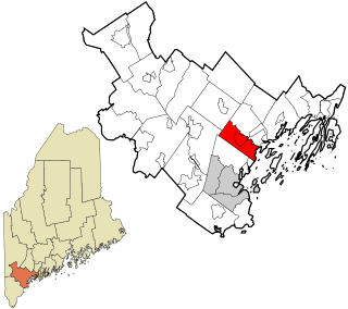
Yarmouth is a town in Cumberland County, Maine, United States, twelve miles north of the state's largest city, Portland. When originally settled in 1636, as North Yarmouth, it was part of the Massachusetts Bay Colony, and remained part of its subsequent incarnations for 213 years. In 1849, twenty-nine years after Maine's admittance to the Union as the twenty-third state, it was incorporated as the Town of Yarmouth.

Littlejohn Island is an island and census-designated place (CDP) in the town of Yarmouth in Cumberland County, Maine, United States. The population of the CDP was 118 at the 2010 census.

Naples is a census-designated place (CDP) in the town of Naples in Cumberland County, Maine, United States. The population of the CDP was 428 at the 2010 census.
The West Side Trail is a multi-use trail in Yarmouth, Maine. A Town of Yarmouth project conceived in 1988 and opened in 2014, the trailhead for the eastern portion of the trail is in the parking lot of Tyler Technologies, on Tyler Drive, on the eastern side of U.S. Route 1, immediately before the exit 15 northbound on-ramp to Interstate 295 (I-295). The trailhead for the western section is in the park and ride lot at the southbound exit 15 ramp for I-295, to the west of Route 1.
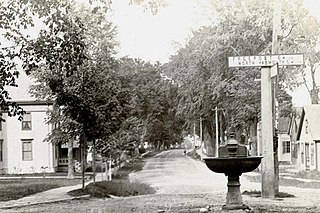
Elm Street is a prominent street in Yarmouth, Maine, United States. It runs for about 2.7 miles (4.3 km) from North Road in the north to Portland Street in the south. The street's addresses are split between "West Elm Street" and "East Elm Street", the transition occurring at Main Street in the Upper Village. Several of its buildings are homes dating to the late 18th and early 19th centuries.

The Royal River Conservation Trust (RRCT) is a volunteer-run conservation group based in Yarmouth, Maine, United States. Established in 1988 and funded by its members, it owns many preserves and trail networks, and has assisted in the creation of town-owned parks and preserves, state parks and state wildlife-management areas. The trust, one of eighty land trusts in Maine, covers seven towns and cities in Androscoggin County and Cumberland County which form the watershed of the Royal River: Yarmouth, North Yarmouth, Pownal, New Gloucester, Gray, Durham and Auburn.

The Chebeague & Cumberland Land Trust is a volunteer-run conservation group based in Cumberland, Maine, United States. Established in 1987 and funded by its members, it owns many preserves and trail networks, and has assisted in the creation of town-owned parks and preserves. The trust, one of eighty land trusts in Maine, covers the towns of Cumberland and Chebeague Island.

Little Chebeague Island is an uninhabited island in Casco Bay, an inlet of the Gulf of Maine, United States. It is located around 0.85 miles (1.37 km) west of the southern tip of the larger Great Chebeague Island. As its name implies, the two are connected—by a sand bar which appears at low tide.
The Brunswick-Topsham Land Trust is a volunteer-run conservation group based in Brunswick, Maine, United States. Established in 1985 and funded by its members, it owns many preserves and trail networks, and has assisted in the creation of town-owned parks and preserves. The trust, one of eighty land trusts in Maine, covers the towns of Brunswick, Topsham and Bowdoin.


