Cumberland, Maine | |
---|---|
Coordinates: 43°46′52″N70°13′3″W / 43.78111°N 70.21750°W | |
Country | United States |
State | Maine |
County | Cumberland |
Villages | Cumberland Center Cumberland Foreside West Cumberland |
Area | |
• Total | 26.25 sq mi (67.99 km2) |
• Land | 22.88 sq mi (59.26 km2) |
• Water | 3.37 sq mi (8.73 km2) |
Elevation | 180 ft (55 m) |
Population (2023) | |
• Total | 8,754 |
• Density | 370/sq mi (143.0/km2) |
Time zone | UTC-5 (Eastern (EST)) |
• Summer (DST) | UTC-4 (EDT) |
ZIP Codes | |
Area code | 207 |
FIPS code | 23-15430 |
GNIS feature ID | 0582427 |
Website | www.cumberlandmaine.com |
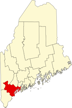
Cumberland is a town in Cumberland County, Maine, United States. The population was 8,473 at the time of the 2020 census. [2] It is part of the Portland metropolitan area, Maine. Cumberland is one of the wealthiest municipalities in the state. [3]
Cumberland, Maine (also known as Cumberland Center), became independent in March 1821 after it split from North Yarmouth. [4] The town was officially named by Ephraim Sturdivant when the new town government elected him to do the task.
The Cumberland Fair, an annual agricultural fair, has been held yearly in Cumberland during the month of September since 1868. [5] This Portland suburb has a rich farming history, but only a small number of working farms remain, such as Sweetser's Apple Barrel & Orchards, Spring Brook Farms, and Double T Orchards. Chebeague Island, long a part of Cumberland, formed its own town in 2007. Since 1960, Cumberland's motto has been "Where what comes around keeps going around!" [6]
According to the United States Census Bureau, the town has a total area of 26.25 square miles (67.99 km2), of which 22.88 square miles (59.26 km2) is land and 3.37 square miles (8.73 km2) is water. [1] The town stretches inland from Cumberland Foreside, on Casco Bay, to West Cumberland, which borders Windham. [7]
Near the center of the town, there is a small recreational park called Twin Brook. Run and maintained by the town, it is open to cross-country skiers, walkers, and sports practices. Local ballfields at Drowne Road School host the local Little League teams. Knight's Pond Preserve, on the border with North Yarmouth, is home to a pond and a large nature preserve used for recreation year round.
Census | Pop. | Note | %± |
---|---|---|---|
1830 | 1,558 | — | |
1840 | 1,616 | 3.7% | |
1850 | 1,656 | 2.5% | |
1860 | 1,713 | 3.4% | |
1870 | 1,626 | −5.1% | |
1880 | 1,619 | −0.4% | |
1890 | 1,487 | −8.2% | |
1900 | 1,404 | −5.6% | |
1910 | 1,403 | −0.1% | |
1920 | 1,150 | −18.0% | |
1930 | 1,378 | 19.8% | |
1940 | 1,491 | 8.2% | |
1950 | 2,030 | 36.2% | |
1960 | 2,765 | 36.2% | |
1970 | 4,096 | 48.1% | |
1980 | 5,284 | 29.0% | |
1990 | 5,836 | 10.4% | |
2000 | 7,159 | 22.7% | |
2010 | 7,211 | 0.7% | |
2020 | 8,473 | 17.5% | |
U.S. Decennial Census [8] |
As of the census [9] of 2010, there were 7,211 people, 2,697 households, and 2,079 families living in the town. The population density was 315.2 inhabitants per square mile (121.7/km2). There were 2,902 housing units at an average density of 126.8 per square mile (49.0/km2). The racial makeup of the town was 97.2% White, 0.5% African American, 0.2% Native American, 0.8% Asian, 0.3% from other races, and 1.0% from two or more races. Hispanic or Latino of any race were 1.2% of the population.
There were 2,697 households, of which 37.9% had men under the age of 18 living with them, 67.4% were married couples living together, 6.5% had a female householder with no husband present, 3.2% had a male householder with no wife present, and 22.9% were non-families. 18.9% of all households were made up of individuals, and 9% had someone living alone who was 65 years of age or older. The average household size was 2.67 and the average family size was 3.06.
The median age in the town was 45 years. 26.9% of residents were under the age of 18; 4.7% were between the ages of 18 and 24; 18.2% were from 25 to 44; 35.6% were from 45 to 64; and 14.5% were 65 years of age or older. The gender makeup of the town was 47.8% male and 52.2% female.
As of the census [10] of 2000, there were 7,159 people, 2,548 households, and 2,046 families living in the town. The population density was 274.6 inhabitants per square mile (106.0/km2). There were 2,945 housing units at an average density of 112.9 per square mile (43.6/km2). The racial makeup of the town was 98.76% White, 0.14% African American, 0.10% Native American, 0.42% Asian, 0.01% Pacific Islander, 0.13% from other races, and 0.45% from two or more races. Hispanic or Latino of any race were 0.66% of the population.
There were 2,548 households, of which 42.3% had children under the age of 18 living with them; 71.0% were married couples living together; 7.1% had a female householder with no husband present; and 19.7% were non-families. 15.7% of all households were made up of individuals, and 7.2% had someone 65 or older living alone. The average household size was 2.80 and the average family size was 3.14.
In the town, the population was spread out, with 30.4% under the age of 18; 3.6% from 18 to 24; 27.7% from 25 to 44; 27.3% from 45 to 64, and 11.0% who were 65 or older. The median age was 39 years. For every 100 females, there were 93.3 males. For every 100 females age 18 and over, there were 91.4 males.
The median income for a household in the town was $67,556, and the median income for a family was $76,571. Males had a median income of $49,538 versus $37,367 for females. The per capita income for the town was $33,644. About 2.4% of families and 3.0% of the population were below the poverty line, including 0.8% of those under age 18 and 6.2% of those age 65 or over.
Cumberland is an incorporated town governed by a council–manager government.
The school system that serves Cumberland is known as Maine School Administrative District 51 or MSAD 51. There are 3 schools in the district—which also serves North Yarmouth, Maine: the Mabel I. Wilson School, Greely Middle School, and Greely High School. In June 2014, the district closed the North Yarmouth Memorial School and moved into the expanded the Greely Middle School. The Drowne Road School was closed in 2010 due to budget cuts, and the Greely Middle School replaced the Greely Junior High School in 2005. Jeff Porter is the superintendent of the district. [11] The Friends School of Portland, serves grades Pre-K through 8. [12]
Cumberland County is a county in the U.S. state of Maine. As of the 2020 census, the population was 303,069, making it the most populous county in Maine. Its county seat is Portland. Cumberland County was founded in 1760 from a portion of York County, Province of Massachusetts Bay, and named for William, Duke of Cumberland, a son of King George II. Cumberland County has the deepest and second-largest body of water in the state, Sebago Lake, which supplies tap water to most of the county. The county is the state's economic and industrial center, having the resources of the Port of Portland, the Maine Mall, and having corporate headquarters of major companies such as onsemi, IDEXX Laboratories, Unum, and TD Bank. Cumberland County is part of the Portland–South Portland, ME Metropolitan Statistical Area.
Baldwin is a town in Cumberland County, Maine, United States. The population was 1,520 at the 2020 census. It is part of the Portland–South Portland–Biddeford, Maine, metropolitan statistical area.
Casco is a town in Cumberland County, Maine, United States. Casco is included in the Lewiston-Auburn, Maine metropolitan New England city and town area. The population was 3,646 at the 2020 census. Casco includes the villages of Casco, South Casco and Cook Mills. The town borders the east shore of Sebago Lake, and is home to part of Sebago Lake State Park. Casco is part of the Portland–South Portland–Biddeford, Maine metropolitan statistical area. Casco is just under 30 miles (48 km) from downtown Portland.
Cumberland Center is a census-designated place (CDP) within the town of Cumberland in Cumberland County, Maine, United States. The population was 2,499 at the 2010 census. It is part of the Portland – South Portland – Biddeford, Maine, Metropolitan Statistical Area.
Gray is a town in Cumberland County, Maine, United States. The population was 8,269 at the 2020 census. It is part of the Portland–South Portland–Biddeford, Maine metropolitan statistical area. and included in the Lewiston-Auburn, Maine metropolitan New England city and town area. Gray is located at the intersection of state Routes 4, 26, 100, 115, 202 and the Maine Turnpike exit 63 midway between the state's two largest cities, Portland and Lewiston. The town includes frontage on Little Sebago Lake, Crystal Lake, and Forest Lake.
Harpswell is a town in Cumberland County, Maine, United States, within Casco Bay in the Gulf of Maine. The population was 5,031 at the 2020 census. Harpswell is composed of land contiguous with the rest of Cumberland County, called Harpswell Neck, as well as three large islands connected by bridges: Sebascodegan Island, Orr's Island, and Bailey Island and over 200 smaller islands. Harpswell is part of the Portland–South Portland–Biddeford, Maine Metropolitan Statistical Area.
Harrison is a town in Cumberland County, Maine, United States. Harrison is included in the Lewiston-Auburn, Maine metropolitan New England city and town area. The population was 2,447 at the 2020 census. A historic resort area, Harrison straddles Long Lake and Crystal Lake. It is part of the Portland–South Portland–Biddeford, Maine metropolitan statistical area.
Naples is a town in Cumberland County, Maine, United States. It is part of the Portland–South Portland–Biddeford, Maine metropolitan statistical area. The population was 3,925 at the 2020 census, and it is home to part of Sebago Lake State Park. Naples is a resort area.
New Gloucester is a town in Cumberland County, Maine, United States. New Gloucester is included in the Lewiston-Auburn, Maine metropolitan New England city and town area. It is home to the Sabbathday Lake Shaker Village, the last active Shaker village in the U.S. The town's population was 5,676 at the 2020 census.
North Yarmouth, officially the Town of North Yarmouth, is a town in Cumberland County, Maine, United States. North Yarmouth is included in the Lewiston-Auburn, Maine metropolitan New England city and town area. The population was 4,072 at the 2020 United States Census. It is part of the Portland–South Portland–Biddeford Metropolitan Statistical Area.
Pownal is a town in Cumberland County, Maine, United States. Pownal was included in the Lewiston-Auburn, Maine metropolitan New England city and town area. The population was 1,566 at the 2020 census. It is part of the Portland–South Portland–Biddeford, Maine Metropolitan Statistical Area. Pownal is home to Bradbury Mountain State Park.
Raymond is a town in Cumberland County, Maine, United States. Raymond is included in the Lewiston-Auburn, Maine metropolitan New England city and town area. The population was 4,536 at the 2020 census. It is a summer recreation area and is part of the Portland–South Portland–Biddeford, Maine metropolitan statistical area. Raymond Neck is the landing for the ferry to the town of Frye Island in Sebago Lake. The Raymond school system is currently affiliated with the Windham school system in a district known as RSU 14.
Sebago is a town in Cumberland County, Maine, United States. The population was 1,911 at the 2020 census. It is part of the Portland–South Portland–Biddeford, Maine metropolitan statistical area.
Standish is a town in Cumberland County, Maine, United States. The population was 10,244 at the 2020 census. It includes the villages of Standish Corner, Sebago Lake Village and Steep Falls, and the localities known as Richville, Elmwood, Standish Neck and Two Trails. Standish is part of the Portland-South Portland-Biddeford, Maine metropolitan statistical area.
Westbrook is a city in Cumberland County, Maine, United States and a suburb of Portland. The population was 20,400 at the 2020 census, making it the fastest-growing city in Maine between 2010 and 2020. It is part of the Portland–South Portland–Biddeford, Maine metropolitan statistical area.
Nobleboro, founded in 1788, is a town in Lincoln County, Maine, United States. The population was 1,791 at the 2020 census. Nobleboro is named for Arthur Noble's son Arthur II. Part of Nobleboro was part of Shem Drowne's claim in the 1730s.
Freeport is a town in Cumberland County, Maine, United States. Freeport is included in the Lewiston-Auburn, Maine metropolitan New England City and town area. The population was 8,737 at the 2020 census. Once home to a prominent shipbuilding industry, timber operations, and farming, it is now known for its numerous outlet stores; Freeport is home to L.L. Bean, Wolfe's Neck Woods State Park, and the Desert of Maine.
Gorham is a town in Cumberland County, Maine, United States. The population was 18,336 at the 2020 United States Census. In addition to its urban village center known as Gorham Village or simply "the Village," the town encompasses a number of smaller, unincorporated villages and hamlets with distinct historical identities, including South Gorham, West Gorham, Little Falls, White Rock, and North Gorham. Gorham is home to one of the three campuses of the University of Southern Maine. In 2013, Gorham was voted second-best town in Maine after Hampden by a financial website.
Yarmouth is a census-designated place (CDP) in the town of Yarmouth in Cumberland County, Maine, United States. The population was 6,125 at the 2020 census. It is part of the Portland–South Portland–Biddeford, Maine Metropolitan Statistical Area.
Yarmouth is a town in Cumberland County, Maine, United States, twelve miles north of the state's largest city, Portland. When originally settled in 1636, as North Yarmouth, it was part of the Massachusetts Bay Colony, and remained part of its subsequent incarnations for 213 years. In 1849, twenty-nine years after Maine's admittance to the Union as the twenty-third state, it was incorporated as the Town of Yarmouth.