Harrison, Maine

Last updated

Harrison, Maine
HarrisonME Ballroom.jpg
The Ballroom (2014)
Cumberland County Maine incorporated and unincorporated areas Harrison highlighted.svg
Location in Cumberland County and the state of Maine.
Coordinates: 44°6′14″N70°39′12″W / 44.10389°N 70.65333°W / 44.10389; -70.65333
Country United States
State Maine
County Cumberland
Incorporated1805
VillagesHarrison
Bolsters Mills
Area
[1]
  Total36.81 sq mi (95.34 km2)
  Land33.19 sq mi (85.96 km2)
  Water3.62 sq mi (9.38 km2)
Elevation
577 ft (176 m)
Population
 (2020)
  Total2,447
  Density74/sq mi (28.5/km2)
Time zone UTC-5 (Eastern (EST))
  Summer (DST) UTC-4 (EDT)
ZIP code
04040
Area code 207
FIPS code 23-31600
GNIS feature ID0582513
Website www.harrisonmaine.org

Harrison is a town in Cumberland County, Maine, United States. Harrison is included in the Lewiston-Auburn, Maine metropolitan New England city and town area. The population was 2,447 at the 2020 census. [2] A historic resort area, Harrison straddles Long Lake and Crystal Lake. It is part of the PortlandSouth PortlandBiddeford, Maine metropolitan statistical area.

Contents

History

The Massachusetts General Court granted Otis Field Plantation in 1771 to James Otis and other heirs of Captain John Gorham and his company for their service in the 1690 Battle of Quebec. It replaced a 1736 grant which had been ruled invalid. In 1797, the plantation was incorporated as Otisfield. On March 8, 1805, Harrison was set off and incorporated from portions of Otisfield and Bridgton. It was named after a principal landowner, Harrison Gray Otis of Boston, the heir of James Otis. [3]

In the autumn of 1792, two brothers from Gorham, John and Nathan Carsley, built a camp and cleared land in Harrison. During the winter they returned to Gorham, coming back in March 1793 with their wives. Because John Carsley and his wife remained in Harrison when Nathan Carsley and his wife resumed living in Gorham until 1796, he is considered the town's first permanent settler. More pioneers arrived, living in log houses chinked with moss. The outlet of Crystal Lake into Long Lake provided water power for industry, and James Sampson erected at Harrison village the first sawmill and gristmill. Over the years other industries followed, including a wire-making business, blacksmithy, shingle mill, harness-maker, foundry, carriage maker, clothing maker and shoe shop. Scribner's Mill (now a museum) was built in 1847 on the Crooked River. On the Bear River, in 1867 the Harrison Water Power Company established the Bear River Woolen Mill, destroyed by fire in 1872. [4]

In 1832, the Cumberland and Oxford Canal opened, connecting Portland with Sebago Lake. A series of 27 locks lifted vessels from sea level at Casco Bay to Sebago Lake, 270 feet (82 m) above sea level. From there they traveled up the Songo River to Brandy Pond, then continued along the Chute River to Long Lake. As the company name indicates, the canal was originally planned to reach Oxford County, but instead terminated at Harrison. The town became a center for trade and transportation, with wharves and warehouses lining the shore. [4]

Caswell Library in 1914, built in 1908 and now on the National Register of Historic Places Caswell Public Library, Harrison, ME.jpg
Caswell Library in 1914, built in 1908 and now on the National Register of Historic Places

In 1847, the Sebago & Long Pond Steam Navigation Company built Fawn, the first steamboat to ply the lakes and waterways. It had a shallow draft to navigate the winding Songo River, with passengers asked to shift sides as ballast to keep both paddlewheels in the water around sharp curves. The lakes became a popular summer tourist destination, with The Elm House (later called The Elms Inn) opening in 1860. When the Portland and Ogdensburg Railroad commenced service to Sebago Lake Station in 1870, the canal was abandoned as obsolete. Beginning in 1898, the Bridgton and Saco River Railroad, a narrow gauge line, delivered freight and passengers directly to Harrison.

In 1906, the Harrison Hotel opened. Camp Kineo operated beside Long Lake as a camp for boys. Today, Harrison remains a recreational area. Harrison is also home to Fernwood Cove, a half-season summer camp for girls on the same spot as Camp Chickawah was. It is located on Island Pond. [5]

In 1936 the Historic Deertrees Theatre was built by Enrica Clay Dillon and is still home to countless theatre, opera and music performances, including the Sebago Long Lake Music Festival.
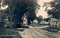
Geography

According to the United States Census Bureau, the town has a total area of 36.81 square miles (95.34 km2), of which 33.19 square miles (85.96 km2) is land and 3.62 square miles (9.38 km2) is water. [1] Harrison is drained by the Bear River and Crooked River.

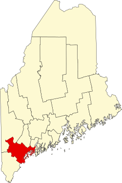
The Maine state routes that cross through Harrison are 35 and 117. Harrison is bordered by the town of Bridgton to its west, Waterford and Norway to its north, Otisfield to its east, and Naples to its south.

Crystal Lake

Crystal Lake
USA Maine relief location map.svg
Red pog.svg
Crystal Lake
Coordinates 44°07′N70°40′W / 44.117°N 70.667°W / 44.117; -70.667 [6]
Primary outflows Long Lake
Basin  countriesUnited States
Max. length1.5 mi (2.4 km) [7]
Surface area446 acres (180 ha) [8]
Max. depth65 feet (20 m) [9]
Water volume14,254  acre⋅ft (17,582,000 m3) [8]
Surface elevation308 ft (94 m) [6]

Crystal Lake (formerly Anonymous Pond) is north of Long Lake, and overflows into Long Lake through downtown Harrison. [7] Smallmouth bass thrive in the lake, with a few lake trout. [9]

Demographics

Historical population
CensusPop.Note
1810 439
1820 78979.7%
1830 1,06835.4%
1840 1,24316.4%
1850 1,41613.9%
1860 1,251−11.7%
1870 1,219−2.6%
1880 1,168−4.2%
1890 1,071−8.3%
1900 969−9.5%
1910 967−0.2%
1920 901−6.8%
1930 9667.2%
1940 1,0266.2%
1950 1,0260.0%
1960 1,014−1.2%
1970 1,0453.1%
1980 1,66759.5%
1990 1,95117.0%
2000 2,31518.7%
2010 2,73017.9%
2020 2,447−10.4%
U.S. Decennial Census [10]

2010 census

As of the census [11] of 2010, there were 2,730 people, 1,113 households, and 779 families living in the town. The population density was 82.3 inhabitants per square mile (31.8/km2). There were 1,761 housing units at an average density of 53.1 per square mile (20.5/km2). The racial makeup of the town was 97.4% White, 0.3% African American, 0.7% Native American, 0.2% Asian, 0.3% from other races, and 1.1% from two or more races. Hispanic or Latino of any race were 0.9% of the population.

There were 1,113 households, of which 29.6% had children under the age of 18 living with them, 55.6% were married couples living together, 8.7% had a female householder with no husband present, 5.7% had a male householder with no wife present, and 30.0% were non-families. 23.0% of all households were made up of individuals, and 8.5% had someone living alone who was 65 years of age or older. The average household size was 2.45 and the average family size was 2.84.

The median age in the town was 45.3 years. 21.3% of residents were under the age of 18; 5.2% were between the ages of 18 and 24; 23.2% were from 25 to 44; 35% were from 45 to 64; and 15.5% were 65 years of age or older. The gender makeup of the town was 51.3% male and 48.7% female.

2000 census

As of the census [12] of 2000, there were 2,315 people, 920 households, and 662 families living in the town. The population density was 70.1 inhabitants per square mile (27.1/km2). There were 1,430 housing units at an average density of 43.3 per square mile (16.7/km2). The racial makeup of the town was 98.79% White, 0.52% African American, 0.04% Native American, 0.04% Pacific Islander, and 0.60% from two or more races. Hispanic or Latino of any race were 0.52% of the population.

There were 920 households, out of which 32.7% had children under the age of 18 living with them, 57.1% were married couples living together, 9.3% had a female householder with no husband present, and 28.0% were non-families. 22.6% of all households were made up of individuals, and 9.6% had someone living alone who was 65 years of age or older. The average household size was 2.52 and the average family size was 2.90.

In the town, the population was spread out, with 25.4% under the age of 18, 5.7% from 18 to 24, 28.6% from 25 to 44, 27.1% from 45 to 64, and 13.3% who were 65 years of age or older. The median age was 40 years. For every 100 females, there were 96.9 males. For every 100 females age 18 and over, there were 96.0 males.

The median income for a household in the town was $35,478, and the median income for a family was $42,159. Males had a median income of $30,726 versus $22,311 for females. The per capita income for the town was $17,898. About 6.9% of families and 9.3% of the population were below the poverty line, including 9.8% of those under age 18 and 5.9% of those age 65 or over.

Notable people

Related Research Articles

<span class="mw-page-title-main">Cumberland County, Maine</span> County in Maine, United States

Cumberland County is a county in the U.S. state of Maine. As of the 2020 census, the population was 303,069, making it the most populous county in Maine. Its county seat is Portland. Cumberland County was founded in 1760 from a portion of York County, Province of Massachusetts Bay, and named for William, Duke of Cumberland, a son of King George II. Cumberland County has the deepest and second-largest body of water in the state, Sebago Lake, which supplies tap water to most of the county. The county is the state's economic and industrial center, having the resources of the Port of Portland, the Maine Mall, and having corporate headquarters of major companies such as Fairchild Semiconductor, IDEXX Laboratories, Unum, and TD Bank. Cumberland County is part of the Portland–South Portland, ME Metropolitan Statistical Area.

<span class="mw-page-title-main">Baldwin, Maine</span> Town in the state of Maine, United States

Baldwin is a town in Cumberland County, Maine, United States. The population was 1,520 at the 2020 census. It is part of the Portland–South Portland–Biddeford, Maine, metropolitan statistical area.

<span class="mw-page-title-main">Casco, Maine</span> Town in the state of Maine, United States

Casco is a town in Cumberland County, Maine, United States. Casco is included in the Lewiston-Auburn, Maine metropolitan New England city and town area. The population was 3,646 at the 2020 census. Casco includes the villages of Casco, South Casco and Cook Mills. The town borders the east shore of Sebago Lake, and is home to part of Sebago Lake State Park. Casco is part of the Portland–South Portland–Biddeford, Maine metropolitan statistical area. Casco is just under 30 miles (48 km) from downtown Portland.

<span class="mw-page-title-main">Frye Island, Maine</span> Town in Maine, United States

Frye Island is an island town in Cumberland County, Maine, United States. Located in Sebago Lake, the island is accessed via a public car ferry from Raymond Neck, or by private boat. All residents of the resort town are seasonal. The majority of property owners hail from New England area states however there are many other states also represented on the island. Frye Island is vacant from November through April, and the ferry does not operate during that time due to thick ice blocking its route during the winter. It is part of the Portland–South Portland–Biddeford, Maine Metropolitan Statistical Area. The town had a population of 32 at the 2020 census.

<span class="mw-page-title-main">Gray, Maine</span> Town in the state of Maine, United States

Gray is a town in Cumberland County, Maine, United States. The population was 8,269 at the 2020 census. It is part of the Portland–South Portland–Biddeford, Maine metropolitan statistical area. and included in the Lewiston-Auburn, Maine metropolitan New England city and town area. Gray is located at the intersection of state Routes 4, 26, 100, 115, 202 and the Maine Turnpike exit 63 midway between the state's two largest cities, Portland and Lewiston. The town includes frontage on Little Sebago Lake, Crystal Lake, and Forest Lake.

<span class="mw-page-title-main">Naples, Maine</span> Town in the United States

Naples is a town in Cumberland County, Maine, United States. It is part of the Portland–South Portland–Biddeford, Maine metropolitan statistical area. The population was 3,925 at the 2020 census, and it is home to part of Sebago Lake State Park. Naples is a resort area.

<span class="mw-page-title-main">North Windham, Maine</span> Census-designated place in Maine, United States

North Windham is a census-designated place (CDP) within the town of Windham in Cumberland County, Maine, United States. The population was 4,904 at the 2010 census. It is part of the Portland–South Portland–Biddeford, Maine Metropolitan Statistical Area.

<span class="mw-page-title-main">Raymond, Maine</span> Town in the state of Maine, United States

Raymond is a town in Cumberland County, Maine, United States. Raymond is included in the Lewiston-Auburn, Maine metropolitan New England city and town area. The population was 4,536 at the 2020 census. It is a summer recreation area and is part of the Portland–South Portland–Biddeford, Maine metropolitan statistical area. Raymond Neck is the landing for the ferry to the town of Frye Island in Sebago Lake. The Raymond school system is currently affiliated with the Windham school system in a district known as RSU 14.

<span class="mw-page-title-main">Sebago, Maine</span> Town in Maine, United States

Sebago is a town in Cumberland County, Maine, United States. The population was 1,911 at the 2020 census. It is part of the Portland–South Portland–Biddeford, Maine metropolitan statistical area.

<span class="mw-page-title-main">Standish, Maine</span> Town in the state of Maine, United States

Standish is a town in Cumberland County, Maine, United States. The population was 10,244 at the 2020 census. It includes the villages of Standish Corner, Sebago Lake Village and Steep Falls, and the localities known as Richville, Elmwood, Standish Neck and Two Trails. Standish is part of the Portland-South Portland-Biddeford, Maine metropolitan statistical area.

<span class="mw-page-title-main">Westbrook, Maine</span> City in Maine, United States

Westbrook is a city in Cumberland County, Maine, United States and a suburb of Portland. The population was 20,400 at the 2020 census, making it the fastest-growing city in Maine between 2010 and 2020. It is part of the Portland–South Portland–Biddeford, Maine metropolitan statistical area.

<span class="mw-page-title-main">Denmark, Maine</span> Town in the state of Maine, United States

Denmark is a town in Oxford County, Maine, United States. The population was 1,197 at the 2020 census. A number of ponds and lakes are located within the town.

Otisfield is a town in Oxford County, Maine, United States. Otisfield is included in the Lewiston-Auburn, Maine metropolitan New England city and town area. The population was 1,853 at the 2020 census. Otisfield is a summer recreation area and home to Seeds of Peace Camp and Camp Arcadia.

<span class="mw-page-title-main">Presumpscot River</span> River in Maine, United States

The Presumpscot River is a 25.8-mile-long (41.5 km) river located in Cumberland County, Maine, United States. It is the main outlet of Sebago Lake. The river provided an early transportation corridor with reliable water power for industrial development of the city of Westbrook and the village of South Windham.

<span class="mw-page-title-main">Cumberland and Oxford Canal</span> United States historic place

The Cumberland and Oxford Canal was opened in 1832 to connect the largest lakes of southern Maine with the seaport of Portland, Maine. The canal followed the Presumpscot River from Sebago Lake through the towns of Standish, Windham, Gorham, and Westbrook. The Canal diverged from the river at Westbrook to reach the navigable Fore River estuary and Portland Harbor. The canal required 27 locks to reach Sebago Lake at an elevation of 267 feet (81 m) above sea level. One additional lock was constructed in the Songo River to provide 5 feet (1.5 m) of additional elevation to reach Long Lake from Sebago Lake. Total navigable distance was approximately 38 miles (61 km) from Portland to Harrison at the north end of Long Lake. A proposed extension from Harrison to Bear Pond and Tom Pond in Waterford would have required three more locks on the Bear River, but they were never built.

<span class="mw-page-title-main">Bridgton (CDP), Maine</span> Census-designated place in Maine, United States

Bridgton is a census-designated place (CDP) in the town of Bridgton in Cumberland County, Maine, United States. The population was 2,071 at the 2010 census. It is part of the Portland–South Portland–Biddeford, Maine Metropolitan Statistical Area.

<span class="mw-page-title-main">Bridgton, Maine</span> Town in Maine, United States

Bridgton is a town in Cumberland County, Maine, United States. The population was 5,418 at the 2020 census. A resort area in Maine's Lakes Region, Bridgton is home to Bridgton Academy, a private preparatory school, and the Four on the Fourth Road Race.

<span class="mw-page-title-main">Gorham (CDP), Maine</span> Census-designated place in Maine, United States

Gorham is a census-designated place (CDP) in the town of Gorham, in Cumberland County, Maine, United States. The population was 6,882 at the 2010 census. It is part of the Portland–South Portland–Biddeford, Maine Metropolitan Statistical Area.

<span class="mw-page-title-main">Gorham, Maine</span> Town in the state of Maine, United States

Gorham is a town in Cumberland County, Maine, United States. The population was 18,336 at the 2020 United States Census. In addition to its urban village center known as Gorham Village or simply "the Village," the town encompasses a number of smaller, unincorporated villages and hamlets with distinct historical identities, including South Gorham, West Gorham, Little Falls, White Rock, and North Gorham. Gorham is home to one of the three campuses of the University of Southern Maine. In 2013, Gorham was voted second-best town in Maine after Hampden by a financial website.

<span class="mw-page-title-main">Naples (CDP), Maine</span> Census-designated place in Maine, United States

Naples is a census-designated place (CDP) in the town of Naples in Cumberland County, Maine, United States. The population of the CDP was 428 at the 2010 census.

References

  1. 1 2 "US Gazetteer files 2010". United States Census Bureau . Retrieved December 16, 2012.
  2. "Census - Geography Profile: Harrison town, Cumberland County, Maine". United States Census Bureau . Retrieved January 16, 2022.
  3. Coolidge, Austin J.; John B. Mansfield (1859). A History and Description of New England. Boston, Massachusetts: A.J. Coolidge. p.  154. coolidge mansfield history description new england 1859.
  4. 1 2 Alphonso Moulton, Howard L. Sampson and Granville Fernald, Centennial History of Harrison, Maine, 1909; published by the Southworth Printing Company, Portland, Maine
  5. Reverend G. T. Ridlon, History of the Settlement and Early Settlers of Harrison, Maine, 1877; Published by Kilby & Woodbury; Skowhegan, Maine 1877
  6. 1 2 U.S. Geological Survey Geographic Names Information System: Crystal Lake
  7. 1 2 The Maine Atlas and Gazetteer (Thirteenth ed.). Freeport, Maine: DeLorme Mapping Company. 1988. p. 10. ISBN   0-89933-035-5.
  8. 1 2 Maine Depts. of Environmental Protection and Inland Fisheries & Wildlife (August 4, 2005). "Maine Lakes: Morphometry and Geographic Information". Senator George J. Mitchell Center for Environmental and Watershed Research, The University of Maine. Archived from the original on September 3, 2006. Retrieved July 31, 2008.
  9. 1 2 "Crystal Lake" (PDF). Maine Department of Inland Fisheries and Wildlife. State of Maine. Retrieved May 17, 2016.
  10. "Census of Population and Housing". Census.gov. Retrieved June 4, 2015.
  11. "U.S. Census website". United States Census Bureau . Retrieved December 16, 2012.
  12. "U.S. Census website". United States Census Bureau . Retrieved January 31, 2008.

Further reading

44°06′37″N70°40′45″W / 44.11028°N 70.67917°W / 44.11028; -70.67917