Cumberland County is a county in the U.S. state of Maine. As of the 2020 census, the population was 303,069, making it the most populous county in Maine. Its county seat is Portland. Cumberland County was founded in 1760 from a portion of York County, Province of Massachusetts Bay, and named for William, Duke of Cumberland, a son of King George II. Cumberland County has the deepest and second-largest body of water in the state, Sebago Lake, which supplies tap water to most of the county. The county is the state's economic and industrial center, having the resources of the Port of Portland, the Maine Mall, and having corporate headquarters of major companies such as onsemi, IDEXX Laboratories, Unum, and TD Bank. Cumberland County is part of the Portland–South Portland, ME Metropolitan Statistical Area.

Casco is a town in Cumberland County, Maine, United States. Casco is included in the Lewiston-Auburn, Maine metropolitan New England city and town area. The population was 3,646 at the 2020 census. Casco includes the villages of Casco, South Casco and Cook Mills. The town borders the east shore of Sebago Lake, and is home to part of Sebago Lake State Park. Casco is part of the Portland–South Portland–Biddeford, Maine metropolitan statistical area. Casco is just under 30 miles (48 km) from downtown Portland.

Frye Island is an island town in Cumberland County, Maine, United States. Located in Sebago Lake, the island is accessed via a public car ferry from Raymond Neck, or by private boat. All residents of the resort town are seasonal. The majority of property owners hail from New England area states however there are many other states also represented on the island. Frye Island is vacant from November through April, and the ferry does not operate during that time due to thick ice blocking its route during the winter. It is part of the Portland–South Portland–Biddeford, Maine Metropolitan Statistical Area. The town had a population of 32 at the 2020 census.
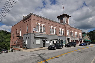
Harrison is a town in Cumberland County, Maine, United States. Harrison is included in the Lewiston-Auburn, Maine metropolitan New England city and town area. The population was 2,447 at the 2020 census. A historic resort area, Harrison straddles Long Lake and Crystal Lake. It is part of the Portland–South Portland–Biddeford, Maine metropolitan statistical area.

Naples is a town in Cumberland County, Maine, United States. It is part of the Portland–South Portland–Biddeford, Maine metropolitan statistical area. The population was 3,925 at the 2020 census, and it is home to part of Sebago Lake State Park. Naples is a resort area.
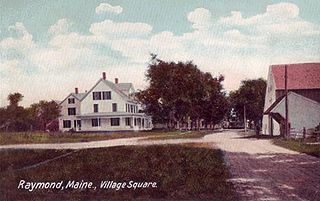
Raymond is a town in Cumberland County, Maine, United States. Raymond is included in the Lewiston-Auburn, Maine metropolitan New England city and town area. The population was 4,536 at the 2020 census. It is a summer recreation area and is part of the Portland–South Portland–Biddeford, Maine metropolitan statistical area. Raymond Neck is the landing for the ferry to the town of Frye Island in Sebago Lake. The Raymond school system is currently affiliated with the Windham school system in a district known as RSU 14.

Sebago is a town in Cumberland County, Maine, United States. The population was 1,911 at the 2020 census. It is part of the Portland–South Portland–Biddeford, Maine metropolitan statistical area.
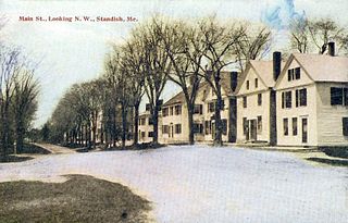
Standish is a town in Cumberland County, Maine, United States. The population was 10,244 at the 2020 census. It includes the villages of Standish Corner, Sebago Lake Village and Steep Falls, and the localities known as Richville, Elmwood, Standish Neck and Two Trails. Standish is part of the Portland-South Portland-Biddeford, Maine metropolitan statistical area.

Windham is a town in Cumberland County, Maine, United States. The population was 18,434 at the 2020 census. It includes the villages of South Windham and North Windham. It is part of the Portland–South Portland–Biddeford, Maine Metropolitan Statistical Area.
Brandy Pond, also known as Bay of Naples Lake, is a small lake in Naples, Maine, United States, that is connected to Long Lake by the Chute River. Brandy Pond is connected to Sebago Lake by the Songo River, which runs through Sebago Lake State Park. To get to Sebago Lake through the Songo River, one must pass through Songo Lock, one of the last remaining hand-operated locks in the country.

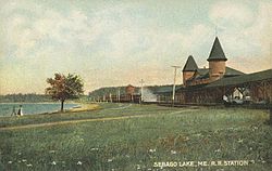
Sebago Lake (Sih-Bay-Goh) is the deepest and second-largest lake in the U.S. state of Maine. The lake is 316 feet (96 m) deep at its deepest point, with a mean depth of 101 feet (31 m). It is possible that Sebago is the deepest lake wholly contained within the entire New England region, although some sources say that Vermont's Lake Willoughby is slightly deeper. Along with Lake Champlain, Sebago is one of the only lakes in the area that do not consistently freeze solid during the winter months, with total ice cover occurring for only a short period of time every few winters. Sebago covers about 45 square miles (117 km2) in surface area, has a length of 14 miles (23 km) and has a shoreline length of roughly 105 miles (169 km). The surface is around 270 feet (82 m) above sea level, so the deep bottom is below the present sea level. It is in Cumberland County, and bordered by the towns of Casco, Naples, Raymond, Sebago, Standish and Windham. The seasonally occupied town of Frye Island is on an island in the lake. Sebago Lake and the surrounding area is known for its erratic and sudden changes in weather during all seasons, likely due to its proximity to the Atlantic Ocean and to Mt. Washington, a very notorious extreme weather hotspot. The name comes from the Abenaki sobagoo, meaning "it is the sea" or "it resembles the sea".

The Presumpscot River is a 25.8-mile-long (41.5 km) river located in Cumberland County, Maine, United States. It is the main outlet of Sebago Lake. The river provided an early transportation corridor with reliable water power for industrial development of the city of Westbrook and the village of South Windham.
Sebago Lake State Park is a public recreation area encompassing 1,342 acres (543 ha) on the north shore of Sebago Lake in the towns of Naples and Casco, Cumberland County, Maine. It opened in 1938 as one of Maine's original five state parks. The mostly forested park is divided into east and west sections by the Songo River. It is managed by the Maine Department of Agriculture, Conservation and Forestry.

The Pleasant River is a 13.1-mile-long (21.1 km) tributary of the Presumpscot River in the U.S. state of Maine.

Naples is a census-designated place (CDP) in the town of Naples in Cumberland County, Maine, United States. The population of the CDP was 428 at the 2010 census.

State Route 114 (SR 114) is a route through southern Maine from U.S. Route 1 (US 1) and SR 9 and SR 207 in Scarborough to US 302 and SR 11 in Naples. The entire route is in Cumberland County.

South Casco is an unincorporated village in the town of Casco, Cumberland County, Maine, United States. The community is located along U.S. Route 302 and Maine State Route 35 near the town's border with Raymond and the north shore of Sebago Lake. South Casco has a post office with ZIP code 04077.
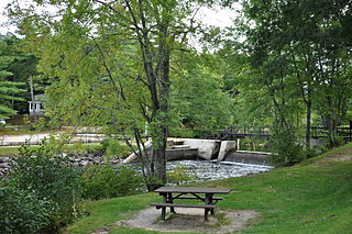
Songo Lock is the last surviving lock of the Cumberland and Oxford Canal, a 19th-century canal in southern Maine, United States. The lock is located on the Songo River, just above its confluence with the Crooked River at the northern end of Sebago Lake State Park in the town of Naples. The lock, built in 1830, is now used primarily during the summer months by pleasure craft. It was listed on the National Register of Historic Places in 1970 and designated as a Maine Historic Civil Engineering Landmark by the American Society of Civil Engineers in 2001.

Douglas Mountain or Douglas Hill is a small mountain in the towns of Sebago, Maine and Baldwin, Maine in the United States. It is named after early European settlers John and Andrew Douglas and was first settled by United States citizens in the 1830s. It is part of a small range called the Saddleback Hills on the west side of Sebago Lake. The peak of the mountain is the second highest point in Cumberland County, Maine
Peabody Pond extends from the southern tip of Bridgton into northern Sebago forming the western boundary of Naples, Maine. The eastern tip of the lake receives drainage from Cold Rain Pond in Naples. The southern tip of the lake overflows as the Northwest River through 5 miles (8.0 km) of boggy land to the western shore of Sebago Lake at East Sebago. The pond has a native population of rainbow smelt, and has been stocked with smallmouth bass, lake trout, and land-locked Atlantic salmon. A boat-launching area near the outlet of the lake is accessible from Tiger Hill Road off Maine State Route 107.