
Brunswick Station was a census-designated place (CDP) within the town of Brunswick in Cumberland County, Maine, United States. The population was 578 at the 2010 census. It consists of an area that was part of the former Naval Air Station Brunswick and was part of the Portland–South Portland–Biddeford, Maine Metropolitan Statistical Area. The 2020 census shows it as part of the Brunswick CDP.

Cumberland Center is a census-designated place (CDP) within the town of Cumberland in Cumberland County, Maine, United States. The population was 2,499 at the 2010 census. It is part of the Portland – South Portland – Biddeford, Maine, Metropolitan Statistical Area.

Falmouth Foreside is a census-designated place (CDP) within the town of Falmouth in Cumberland County, Maine, United States. As of the 2010 census, the CDP population was 1,511. It is part of the Portland–South Portland–Biddeford, Maine Metropolitan Statistical Area.

Naples is a town in Cumberland County, Maine, United States. It is part of the Portland–South Portland–Biddeford, Maine metropolitan statistical area. The population was 3,925 at the 2020 census, and it is home to part of Sebago Lake State Park. Naples is a resort area.

North Windham is a census-designated place (CDP) within the town of Windham in Cumberland County, Maine, United States. The population was 4,904 at the 2010 census. It is part of the Portland–South Portland–Biddeford, Maine Metropolitan Statistical Area.

Springvale is a village and former census-designated place in the city of Sanford in York County, Maine, United States. The population was 3,292 at the 2010 census. It is part of the Portland–South Portland–Biddeford, Maine metropolitan statistical area. The CDP was abolished when the town of Sanford reincorporated as a city.

Oak Hill is a census-designated place (CDP) in the town of Scarborough in Cumberland County, Maine, United States. Prior to the 2020 census, the CDP was known as Scarborough. The population was 4,403 at the 2010 census. It is part of the Portland–South Portland–Biddeford, Maine Metropolitan Statistical Area.
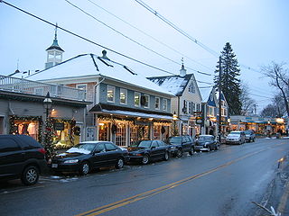
Kennebunkport is a census-designated place (CDP) consisting of the central village in the town of Kennebunkport in York County, Maine, United States. The population was 1,238 at the 2010 census, out of a total town population of 3,474. It is part of the Portland–South Portland–Biddeford, Maine Metropolitan Statistical Area.

Kittery is a census-designated place (CDP) consisting of the main village in the town of Kittery in York County, Maine, United States. The village is also known as Kittery Foreside. The population of the CDP was 4,562 at the 2010 census. It is part of the Portland–South Portland–Biddeford, Maine Metropolitan Statistical Area.

Steep Falls is a census-designated place (CDP) in the town of Standish in Cumberland County, Maine, United States. The population was 1,139 at the 2010 census. It is part of the Portland–South Portland–Biddeford, Maine Metropolitan Statistical Area. The town is part of Maine School Administrative District #6, which includes Bonny Eagle Middle and High Schools.

South Windham is a census-designated place (CDP) in the town of Windham in Cumberland County, Maine, United States. The population of the CDP was 1,374 at the 2010 census. Prior to 2010, South Windham was part of the Little Falls-South Windham census-designated place.

Freeport is a census-designated place (CDP) in the town of Freeport in Cumberland County, Maine, United States. The population was 1,485 at the 2010 census. It is part of the Portland–South Portland–Biddeford, Maine Metropolitan Statistical Area.

Gorham is a census-designated place (CDP) in the town of Gorham, in Cumberland County, Maine, United States. The population was 6,882 at the 2010 census. It is part of the Portland–South Portland–Biddeford, Maine Metropolitan Statistical Area.

Yarmouth is a census-designated place (CDP) in the town of Yarmouth in Cumberland County, Maine, United States. The population was 6,125 at the 2020 census. It is part of the Portland–South Portland–Biddeford, Maine Metropolitan Statistical Area.

Casco is a census-designated place (CDP) in the town of Casco in Cumberland County, Maine, United States. The population of the CDP was 587 at the 2010 census. It is part of the Portland–South Portland–Biddeford, Maine Metropolitan Statistical Area.

Falmouth is a census-designated place (CDP) within the town of Falmouth in Cumberland County, Maine, United States. The population was 1,855 at the 2010 census. It is part of the Portland–South Portland–Biddeford, Maine Metropolitan Statistical Area.

Gray is a census-designated place (CDP) within the town of Gray, in Cumberland County, Maine, United States. The population was 884 at the 2010 census., comprising 11.4% of the town's population of 7,761.

Little Falls is a census-designated place (CDP) in the town of Gorham in Cumberland County, Maine, United States. The population of the CDP was 708 at the 2010 census. Prior to 2010, Little Falls was part of the Little Falls-South Windham census-designated place.

Littlejohn Island is an island and census-designated place (CDP) in the town of Yarmouth in Cumberland County, Maine, United States. The population of the CDP was 118 at the 2010 census.

Standish, known locally as Standish Corner, is a census-designated place (CDP) in the town of Standish in Cumberland County, Maine, United States. The population was 469 at the 2010 census. It is part of the Portland–South Portland–Biddeford, Maine Metropolitan Statistical Area.


