
Casco is a town in Cumberland County, Maine, United States. Casco is included in the Lewiston-Auburn, Maine metropolitan New England city and town area. The population was 3,646 at the 2020 census. Casco includes the villages of Casco, South Casco and Cook Mills. The town borders the east shore of Sebago Lake, and is home to part of Sebago Lake State Park. Casco is part of the Portland–South Portland–Biddeford, Maine metropolitan statistical area. Casco is just under 30 miles (48 km) from downtown Portland.
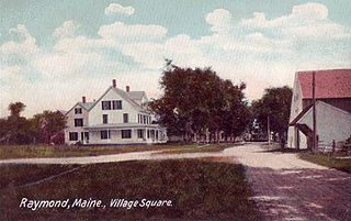
Raymond is a town in Cumberland County, Maine, United States. Raymond is included in the Lewiston-Auburn, Maine metropolitan New England city and town area. The population was 4,536 at the 2020 census. It is a summer recreation area and is part of the Portland–South Portland–Biddeford, Maine metropolitan statistical area. Raymond Neck is the landing for the ferry to the town of Frye Island in Sebago Lake. The Raymond school system is currently affiliated with the Windham school system in a district known as RSU 14.

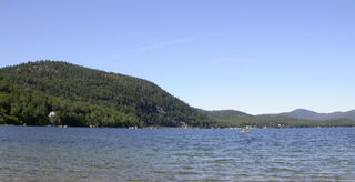
Sebago Lake (Sih-Bay-Goh) is the deepest and second-largest lake in the U.S. state of Maine. The lake is 316 feet (96 m) deep at its deepest point, with a mean depth of 101 feet (31 m). It is possible that Sebago is the deepest lake wholly contained within the entire New England region, although some sources say that Vermont's Lake Willoughby is slightly deeper. Along with Lake Champlain, Sebago is one of the only lakes in the area that do not consistently freeze solid during the winter months, with total ice cover occurring for only a short period of time every few winters. Sebago covers about 45 square miles (117 km2) in surface area, has a length of 14 miles (23 km) and has a shoreline length of roughly 105 miles (169 km). The surface is around 270 feet (82 m) above sea level, so the deep bottom is below the present sea level. It is in Cumberland County, and bordered by the towns of Casco, Naples, Raymond, Sebago, Standish and Windham. The seasonally occupied town of Frye Island is on an island in the lake. Sebago Lake and the surrounding area is known for its erratic and sudden changes in weather during all seasons, likely due to its proximity to the Atlantic Ocean and to Mt. Washington, a very notorious extreme weather hotspot. The name comes from the Abenaki sobagoo, meaning "it is the sea" or "it resembles the sea".
Newfound Lake is located in Grafton County, New Hampshire, United States. It is situated in the Lakes Region of central New Hampshire, in the towns of Alexandria, Bridgewater, Bristol, and Hebron. Its area of 4,451 acres (18.0 km2) places it behind only Lake Winnipesaukee and Squam Lake among lakes located entirely within New Hampshire, and fourth in the state overall, when Umbagog Lake on the Maine border is included.

The Sebasticook River is a 76-mile-long (122 km) river in the central part of Maine, in the United States. From its source in Dexter, the upper "Main Stream" section flows generally west and south 30 miles (48 km) to Great Moose Lake. From the outlet of the lake in Hartland, the Sebasticook flows 41 miles (66 km) south to the Kennebec River in Winslow.
Spednic Lake is a mesotrophic lake in the Chiputneticook Lakes chain along the Canada–United States border between the state of Maine and the province of New Brunswick that is best known for its bass fishing. Sometimes it is viewed as the headwaters of the St. Croix River, sometimes a lake further up the chain is considered the headwaters. The international border runs through the lake. A northeastern arm of the lake, located entirely in Canada, retains the name Palfrey Lake. Prior to dam construction that expanded Spednic Lake they were separate lakes, but now they are hydrologically and ecologically a single combined lake.
The Crooked River is a 58.0-mile-long (93.3 km) tributary of the Songo River in Maine. It is the longest of the tributaries of Sebago Lake, the outlet of which is the Presumpscot River, flowing to Casco Bay on the Atlantic Ocean.
The East Branch Mattawamkeag River is a tributary of the Mattawamkeag River in Aroostook County, Maine. From its source in Dudley, the river runs 36 miles (58 km) south and southeast to its confluence with the West Branch Mattawamkeag River in Haynesville, about 10 miles (16 km) west of the Canada–United States border.
The Harraseeket River is a 3.2-mile-long (5.1 km) tidal river in the town of Freeport within the U.S. state of Maine. It forms a northern arm of Casco Bay.

The Medomak River, historically known as the Muscongus River, is a 40-mile-long (64 km) river in Maine. From its source in Liberty, the river winds 32 miles (51 km) south to the head of its tidal river estuary in Waldoboro, then about 8 miles (13 km) south to Bremen. The river flows through Hockomock Channel into the head of Muscongus Bay. Medomak is Abenaki for "place (river) of many alewives".
The Sabattus River is an 11.4-mile-long (18.3 km) tributary of the Androscoggin River in Maine. It rises at the outlet of Sabattus Pond in the town of Sabattus and flows south into the town of Lisbon, reaching the Androscoggin just southeast of Lisbon Center and about 1.5 miles (2.4 km) upstream (northwest) of Lisbon Falls. Via the Androscoggin River, water from the Sabattus River flows to the Kennebec River at Merrymeeting Bay and ultimately to the Atlantic Ocean.
The Tenny River is a 1.0-mile-long (1.6 km) navigable stream connecting Crescent Lake with Panther Pond in the town of Raymond in the U.S. state of Maine. The river drops just one foot in elevation over its course, from 278 feet (85 m) above sea level at Crescent Lake to 277 feet (84 m) at Panther Pond, the outlet of which then drops another 10 feet (3.0 m) to Sebago Lake. The Tenny River is part of the Presumpscot River watershed, flowing to Casco Bay, an arm of the Atlantic Ocean.

Moose Pond is located in the towns of Bridgton, Denmark and Sweden, in the state of Maine. Camp Winona, a camp for boys, Camp Wyonegonic, a camp for girls, and Pleasant Mountain Ski Area, a ski resort, are located on the pond.

State Route 85 is an American road, part of Maine's system of numbered state highways, located in the southern central part of the state. It runs for eight miles (13 km), connecting U.S. Route 302 (US 302) and SR 35 in Raymond to SR 11 in Casco.
Panther Pond is a lake located in Raymond, Maine, in Cumberland County. Panther Pond is approximately 3 miles (4.8 km) long and 1 mile (1.6 km) wide. The deepest part of the lake is approximately 70 feet (21 m). Panther Pond is connected to two lakes. The first, the much larger Sebago Lake is connected by a run-out of Panther Pond named Panther Run. The connection between the two lakes are separated by a dam that is opened annually to let species of fish to flow through. The other lake, Crescent Lake, is connected to Panther Pond by the Tenny River.
Lovewell Pond is a sizable body of water located in southeastern Fryeburg, Maine. It has a moderately developed shoreline with approximately 75-80 buildings, not including approximately 35 others with access rights to the pond's shoreline.
Camp Agawam is a boys' camp located on Crescent Lake in Raymond, Maine, United States, and is one of the oldest summer camps for boys in the United States. The camp was founded in 1919 by Appleton A. Mason, and remained in the Mason family until 1985. The Boston Globe described the camp in 1988 as "an old camp with old ideas." However, in 2009, Senator Susan Collins described its program as "unique and exciting." It is noted for its award-winning charitable program, Main Idea, which enables underprivileged boys to attend the camp. The camp is run as a non-profit organization, directed by Erik Calhoun.
The Fish River chain of lakes is a series of five lakes in the North Maine Woods region of northern Maine, in a tributary stream to the Fish River. The lakes are an important northern Maine recreation area providing habitat for wildlife including rainbow smelt, brook trout, lake trout, and land-locked Atlantic salmon.
Thomas Pond is adjacent to U.S. Route 302 on the border of Raymond and Casco, Maine. The shoreline is heavily developed with residences and seasonal cabins, and there is a boat launching area near the highway where the pond overflows into Sebago Lake. White perch, chain pickerel, smallmouth bass, and largemouth bass thrive in the shallow portions of the pond; and land-locked Atlantic salmon use the deeper parts of the pond preying on rainbow smelt.
Hancock Brook is an east-bank tributary to the Saco River at Hiram, Maine. The brook originates in eastern Denmark and flows through a chain of ponds along the border between Hiram and Sebago. The narrow-gauge Bridgton and Saco River Railroad was built along the brook in 1882, and operated until 1941.

