
Victoria Island is a large island in the Arctic Archipelago that straddles the boundary between Nunavut and the Northwest Territories of Canada. It is the eighth largest island in the world, and at 217,291 km2 (83,897 sq mi) in area, it is Canada's second largest island. It is nearly double the size of Newfoundland (111,390 km2 [43,010 sq mi]), and is slightly larger than the island of Great Britain (209,331 km2 [80,823 sq mi]) but smaller than Honshu (225,800 km2 [87,200 sq mi]). The western third of the island lies in the Inuvik Region of the Northwest Territories; the remainder is part of Nunavut's Kitikmeot Region.

The Isle of Purbeck is a peninsula in Dorset, England. It is bordered by water on three sides: the English Channel to the south and east, where steep cliffs fall to the sea; and by the marshy lands of the River Frome and Poole Harbour to the north. Its western boundary is less well defined, with some medieval sources placing it at Flower's Barrow above Worbarrow Bay. John Hutchins, author of The History and Antiquities of the County of Dorset, defined Purbeck's western boundary as the Luckford Lake steam, which runs south from the Frome. According to writer and broadcaster Ralph Wightman, Purbeck "is only an island if you accept the barren heaths between Arish Mell and Wareham as cutting off this corner of Dorset as effectively as the sea." The most southerly point is St Alban's Head.

Purbeck was a local government district in Dorset, England. The district was named after the Isle of Purbeck, a peninsula that forms a large proportion of the district's area. However, it extended significantly further north and west than the traditional boundary of the Isle of Purbeck which is the River Frome. The district council was based in the town of Wareham, which is itself north of the Frome.
Gateholm or Gateholm Island is a small tidal island off the south west coast of Pembrokeshire, in the community of Marloes and St Brides, in the south west side of Wales, in the west of the UK, and about 8 miles (13 km) west of the port of Milford Haven. It is known for its Romano-British remains. Gateholm is owned by the National Trust as part of their Marloes Sands and Mere estate.

The Celtic Sea is the area of the Atlantic Ocean off the southern coast of Ireland bounded to the east by Saint George's Channel; other limits include the Bristol Channel, the English Channel, and the Bay of Biscay, as well as adjacent portions of Wales, Cornwall, and Brittany. The southern and western boundaries are delimited by the continental shelf, which drops away sharply. The Isles of Scilly are an archipelago of small islands in the sea.

The Virgin Islands National Park is an American national park preserving about 60% of the land area of Saint John in the United States Virgin Islands, as well as more than 5,500 acres of adjacent ocean, and nearly all of Hassel Island, just off the Charlotte Amalie, Saint Thomas harbor.

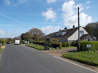
Niton is a village on the Isle of Wight, west of Ventnor, with a population of 2,082. It has two pubs, several churches, a pottery workshop/shop, a pharmacy, a busy volunteer-run library, a medical centre and two local shops including a post office. The post office includes a pub and café that serves as a local meeting place. The village also offers a primary school with a co-located pre-school and nursery.

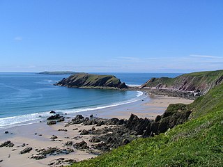
Godrevy is an area on the eastern side of St Ives Bay, west Cornwall, England, United Kingdom, which faces the Atlantic Ocean. It is popular with both the surfing community and walkers. It is part owned by the National Trust, and offshore on Godrevy Island is a lighthouse maintained by Trinity House which is said to be the inspiration for Virginia Woolf's novel To the Lighthouse. Godrevy lies within the Cornwall Area of Outstanding Natural Beauty (AONB) and the South West Coast Path runs around the whole promontory. There are several public car parks on the western side where the National Trust owns and operates a café.

Richmond is a suburb of Sheffield in South Yorkshire, England. It lies in the eastern part of the city.
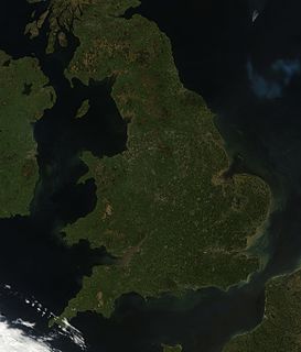
England comprises most of the central and southern two-thirds of the island of Great Britain, in addition to a number of small islands of which the largest is the Isle of Wight. England is bordered to the north by Scotland and to the west by Wales. It is closer to continental Europe than any other part of mainland Britain, divided from France only by a 33 km (21 mi) sea gap, the English Channel. The 50 km (31 mi) Channel Tunnel, near Folkestone, directly links England to mainland Europe. The English/French border is halfway along the tunnel.
Baynes Sound is the channel between Denman Island and Vancouver Island, British Columbia, Canada. The sound is a narrow western offshoot of the Strait of Georgia that separates Vancouver Island from the mainland of British Columbia. The area is actively harvested by the local oyster industry, as is apparent by an abundance of oyster farms. It produces 39% of the oysters and 55% of the manila clams farmed in British Columbia. The sound is 40 km (25 mi) long and is 3.5 km (2.2 mi) wide at its widest point, although the average width is less than 2 km (1.2 mi). The southern boundary lies around Chrome Island, a small island off Boyle Point, the southern tip of Denman. The northern boundary is less defined, but lies between Tree Island at the northern end of Denman and the Comox harbour. The sound is dotted with the small communities of Royston, Union Bay, Buckley Bay, Mud Bay, Fanny Bay, and Deep Bay on Vancouver Island. The crossing is served by the British Columbia Ferry Services Inc. ship MV Baynes Sound Connector, between Buckley Bay and Denman Island. Baynes Sound is named after British Rear Admiral Robert L. Baynes, who commanded the Pacific Squadron from 1857 to 1860. Baynes Sound is the home of Vancouver Island University Center for Shellfish Research's Deep Bay Marine Field Station.
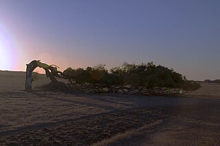
Greenough is a historical settlement situated in a floodplain 400 kilometres north of Perth, Western Australia and 24 kilometres south of Geraldton on the Brand Highway. The settlement's historical buildings are mostly built of local limestone and date to the second half of the 19th century. A sizeable collection of these are owned and managed by the National Trust of Australia. A remarkable feature of the Greenough Flats is its windswept trees, some of which are bent 90 degrees due to the prevailing coastal winds.
The South River is a 10-mile-long (16 km) tributary of the Chesapeake Bay in Anne Arundel County, Maryland in the United States. It lies south of the Severn River, east of the Patuxent River, and north of the West River and Rhode River, and drains to the Chesapeake Bay.
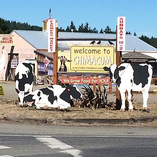
Chimacum is an unincorporated community in Jefferson County, Washington, United States, located in the center of the primary agricultural area of the eastern Olympic Peninsula. It was named after the Chimakum group of Indigenous Americans that lived there until the late 19th century but are now extinct as a distinct cultural group. Chimacum Creek is named after the Chimakum, a Native American people known to themselves as Aqokúlo, who lived on the northeastern portion of the Olympic Peninsula through the mid-19th century and whose economy, culture and religion were based on salmon fishing. Their primary settlements were on Port Townsend Bay, on the Quimper Peninsula, and Port Ludlow Bay to the south. According to tradition, the Chimakum were a remnant of a Quileute band who had been carried away in their canoes by a great flood through a passageway in the Olympic Mountains and deposited on the other side of the peninsula. In 1855 the Twana and Chimakum, along with the Klallam, signed the Point No Point Treaty, which established a reservation at the mouth of the Skokomish River near the southern end of Hood Canal. One of the Chimakum signatories of the treaty was Chief Kulkakhan, also known as General Pierce. After this, most Chimakum people merged into the S’Klallam and Skokomish tribes, where their descendants still live today.

Newtown River is a large natural inland harbour located on the Isle of Wight's northwestern coast, named after the nearby village of Newtown. It is sometimes also referred to as Newtown Creek.
Queen's Bower is a hamlet on the Isle of Wight, England that has effectively merged with Winford and Apse Heath to create a village. It is classed as part of Sandown, with the postcode PO36. It is in the civil parish of Newchurch, Isle of Wight. Transport is provided by Southern Vectis bus route 8 to Sandown, which stops at Hairpin Bend on Alverstone Road once every hour throughout the day, which is right on the perimeter of Borthwood Copse.
The Little Magothy River runs 2.5 miles (4.0 km) through Anne Arundel County in the U.S. state of Maryland. It is located southeast of the Magothy River, just outside its mouth and north of the Severn River.
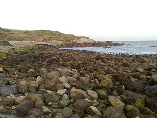
Watershoot Bay is a bay on the southernmost tip of the Isle of Wight, England. It lies 1+1⁄2 miles (2.4 km) to the south-west of the village of Niton. It faces south out into the English Channel, and is one of the smallest and remotest bays of the Isle of Wight with a rocky shoreline only around 500 feet (150 m) in length. It lies to the west of St. Catherine's Point lighthouse and is surrounded by a 170-acre area of undulating grassland and scrub owned by the National Trust and known as Knowles Farm.

Ringmore is a village and a civil parish located on the coast of Devon, England.The population taken at the 2011 census was 208.
