Surat Thani, often shortened to Surat, is the largest of the southern provinces (changwat) of Thailand. It lies on the western shore of the Gulf of Thailand. Surat Thani means "city of good people", a title given to the city by King Vajiravudh.

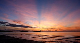
The Gulf of Thailand, also known as the Gulf of Siam, is a shallow inlet in the western part of the South China Sea, a marginal body of water in the western Pacific Ocean. The gulf is around 800 km (497 mi) long and up to 560 km (348 mi) wide, has a surface area of 320,000 km2 (123,553 sq mi) and is surrounded on the north, west and southwest by Thailand, on the northeast by Cambodia and Vietnam. The South China Sea is to the southeast.

Chumphon is a southern province (changwat) of Thailand on the Gulf of Thailand. Neighbouring provinces are Prachuap Khiri Khan, Surat Thani, and Ranong. To the west it borders the Burmese province of Tanintharyi.

Narathiwat is one of the southern provinces (changwat) of Thailand. Neighboring provinces are Yala and Pattani. To the south it borders the Malaysian state of Kelantan. The southern railway line ends in this province, which is one of the nation's four provinces that border Malaysia. The province features a range of cultures as well as natural resources, and is relatively fertile. Narathiwat is about 1,140 kilometers south of Bangkok and has an area of 4,475 square kilometers. Seventy-five percent of the area is jungle and mountains and has a tropical climate.

Surat Thani is a city in Amphoe Mueang Surat Thani, Surat Thani Province, southern Thailand. It lies 651 km south of Bangkok. It is the capital of Surat Thani Province. The city has a population of 128,179 (2009), and an area of 68.97 square kilometers. The city's population density is 1,858.47 inhabitants per km².

Ngāi Tahu, or Kāi Tahu, is the principal Māori iwi (tribe) of the southern region of New Zealand. Its takiwā is the largest in New Zealand, and extends from Blenheim, Mount Mahanga and Kahurangi Point in the north to Stewart Island in the south. The takiwā comprises 18 rūnanga corresponding to traditional settlements.

Chumphon is a town in southern Thailand, capital of the Chumphon Province and Mueang Chumphon District. The city is about 463 kilometers from Bangkok. As of 2005 it had a population of 33,522. The town covers the commune (tambon) Tha Taphao completely and parts of tambons Bang Mak, Wang Phai, Na Thung, Tak Daet, and Khun Krathing. Its main economic activity is agriculture.

Quảng Ngãi is a province in the South Central Coast region of Vietnam, on the coast of East Sea. It is located 883 kilometres (549 mi) south of Hanoi and 838 kilometres (521 mi) north of Hồ Chí Minh City.

Quảng Ngãi is a city in central Vietnam. It is the township of Quảng Ngãi Province. Quảng Ngãi City borders Tư Nghĩa District on the south, west and east and borders Sơn Tịnh District on the north. It has an area of 37.12 km² and population of 119,251 inhabitants.

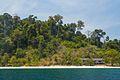
Ko Lanta Yai is in the Andaman Sea off the west coast of Thailand, between the Phi Phi Islands and the mainland. It is administratively part of Krabi Province, most of which is on the mainland. Together with neighboring Ko Lanta Noi which forms Ko Lanta archipelago and several other islands it forms the amphoe of Ko Lanta District. The island is 25 km (16 mi) long and 6 km (3.7 mi) wide, with an area of 81 km2 (31 sq mi), and a small portion of it belongs to the Mu Ko Lanta National Park. The area was designated as the 62nd national park of Thailand in 1990.

South Central Coast is one of the regions of Vietnam. It consists of the independent municipality of Đà Nẵng and seven other provinces. The two southern provinces Ninh Thuận and Bình Thuận are sometimes seen as part of the Southeast region.The Paracel Islands, and Spratly Islands, are also part of this region.
Su-ngai Kolok is a border town on the Malaysia-Thailand Border in Narathiwat Province, Thailand. It is one of the largest and most prosperous districts in Narathiwat Province. It is also one of the major economic centers in the southern part of Thailand. It is capital of the Su-ngai Kolok District. As of 2005, the town had a population of 38,612. Across the border is Rantau Panjang, Kelantan, Malaysia.

Ko Tarutao island is the largest island of Tarutao National Marine Park in Satun Province of Thailand, close to Malaysia border. The island is 26 km (16 mi) long and 11 km (7 mi) wide. It is one of the most unspoiled islands in Andaman Sea and in all of Thailand. The Malay word tertua or tarutao means old and primitive.

Su-ngai Kolok is a district (amphoe) of Narathiwat Province, southern Thailand.

Mu Ko Lanta National Park is a national park in the southern part of Krabi Province, Thailand, consisting of several islands. The two largest islands are Ko Lanta Noi and Ko Lanta Yai. Although both are inhabited, Ko Lanta Yai is the primary tourist destination. The park was established in 1990.

Yala railway station is in Sateng Sub-district, Yala City, Yala Province. It is a class 1 station, 1,038.744 km (645.4 mi) from Thon Buri railway station. It opened in November 1919 as part of the Southern Line Khlong Sai-Balo section. The railway extended to Su-ngai Kolok in September 1921 to connect to the Malaysian railways.

Sungai Golok railway station is a railway station in Sungai Golok Sub-district, Su-ngai Kolok District, Narathiwat. It is a class 1 railway station 1,142.993 km (710.2 mi) from Thon Buri railway station. Sungai Golok Station is the furthest railway station from Bangkok, and the terminus of the Southern Line.

Mu Ko Chumphon National Park(Thai: อุทยานแห่งชาติหมู่เกาะชุมพร, pronounced [mùː kɔ̀ʔ chùm.pʰɔ̄ːn]) is a national park of Thailand consisting of a group of islands in the Gulf of Thailand off the coast of, and part of, Chumphon Province, southern Thailand. Its old name was Had Sai Ree. It was renamed "Mu ko Chumphon" and established as a national park in 1989 by the forestry department. The area is about 323.76 square kilometres (125.00 sq mi). Mu Ko Chumphon National Park has many types of natural resources. Its forests, mostly tropical rainforest, are a type found only on the mountain and on large islands. They provide shelter and habitats for many living things.