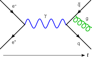
In theoretical physics, quantum field theory (QFT) is a theoretical framework that combines classical field theory, special relativity, and quantum mechanics and is used to construct physical models of subatomic particles and quasiparticles.
Phang Nga is one of the southern provinces (changwat) of Thailand, on the shore of the Andaman Sea to the west and Phang Nga Bay to the south. Neighboring provinces are Ranong, Surat Thani, and Krabi. To the south is the Phuket Province, connected by the Sarasin Bridge.

Ko Phi Phi Le or Ko Phi Phi Leh is an island of the Phi Phi Archipelago, in the Strait of Malacca. It is in Krabi Province of Thailand and is part of Hat Noppharat Thara–Mu Ko Phi Phi National Park

The Phi Phi Islands are an island group in Thailand, between the large island of Phuket and the Straits of Malacca coast of Thailand. The islands are administratively part of Krabi Province. Ko Phi Phi Don is the largest and most populated island of the group, although the beaches of the second largest island, Ko Phi Phi Le are visited by many people as well. The rest of the islands in the group, including Bida Nok, Bida Nai, and Bamboo Island, are not much more than large limestone rocks jutting out of the sea. The islands are reachable by speedboats or long-tail boats most often from Krabi town or from piers in Phuket Province.

Mu Ko Ang Thong is a marine national park in the Gulf of Thailand in Surat Thani Province. It covers 42 islands in a total area of 102 km2, of which about 50 km2 are land and the rest is water. The park was established on 12 November 1980. The northern tip of Ko Phaluai is also part of the marine park. There is a ranger station, bungalows, a shop, and a restaurant at Ao Phi Beach on Ko Wua Talap.
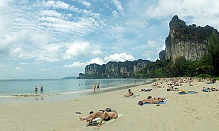
Railay, also known as Rai Leh, is a large peninsula between the city of Krabi and Ao Nang in Thailand. It is accessible only by boat due to high limestone cliffs cutting off mainland access. These cliffs attract rock climbers from all over the world, but the area is also popular due to its beautiful beaches and quiet relaxing atmosphere. Accommodation ranges from bungalows and medium-priced resorts in East Railay to a collection of luxury resorts focused on West Railay, though one, Rajavadee, spans both waterfronts and also has a beachfront restaurant at Ao Phra Nang. The four main areas of Railay consist of Phra Nang, West Railay, East Railay, and Ton Sai. Ton Sai caters to climbers and the backpacker set and is more rustic in character than the glitz of West Railay and the shops and restaurants of the East Railay boardwalk.

The Surin Islands is an archipelago of five islands in the Andaman Sea, 60 km from the Thai mainland. Administratively, the islands are part of Tambon Ko Phra Thong, Khura Buri District, in Phang Nga Province, Thailand.

Ko Lanta Yai is in the Andaman Sea off the west coast of Thailand, between the Phi Phi Islands and the mainland. It is administratively part of Krabi Province, most of which is on the mainland. Together with neighboring Ko Lanta Noi which forms Ko Lanta archipelago and several other islands it forms the amphoe of Ko Lanta District. The island is 25 km (16 mi) long and 6 km (3.7 mi) wide, with an area of 81 km2 (31 sq mi), and a small portion of it belongs to the Mu Ko Lanta National Park. The area was designated as the 62nd national park of Thailand in 1990.
Mukkawar Island is a small shore island of the Red Sea, at the northern entrance to Foul Bay in the Red Sea Governorate of Egypt.

Mu Ko Phetra is a marine national park in the Strait of Malacca off Thailand, covering mostly intact coastal line, open water, and about 30 islands of the southern part of Trang Province and the northern part of Satun Province. Established on 31 December 1984, it is the 49th national park and 14th marine national park of Thailand.
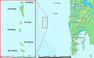
The Similan Islands is a group of islands in the Andaman Sea off the coast of, and part of, Phang Nga Province, southern Thailand. It is a national park, Mu Ko Similan, which was established in 1982 after a one-year assessment by the forestry department.

Ko Phra Thong is an island in Khura Buri district, Phang Nga Province, southern Thailand in the Andaman Sea. It has an area of 88 km² and is separated from the mainland by a seven metre deep canal. It is off the west coast of Thailand and the closest town is the port town of Khura Buri, on the mainland about 10 km east.
In physics, a gauge theory is a type of field theory in which the Lagrangian is invariant under certain Lie groups of local transformations.

Hat Noppharat Thara-Mu Ko Phi Phi National Park lies in the Ao Nang, Sai Thai, and Pak Nam Sub-districts of Amphoe Mueang Krabi, Krabi Province, Thailand. It is a marine national park. Established in 1983, it is an IUCN Category II protected area with coral reefs, and an area measuring 387.9 square kilometres (149.8 sq mi).
Mu Ko Siboya, also known as Ko Siboya Tambon, is a group of islands which is part of Nuea Khlong District in Krabi Province, Thailand. The Islands are located 15–30 kilometers south of Krabi town on the Andaman Sea.

Ko Phithak or Phithak Island is a small island in Thailand, in Chumphon Province on the eastern shore of the Gulf of Thailand. The island has an area of about 1.1392 km2 and there are about 42 households. Most of the local people are Buddhists who earn money by exporting seafood. Other sources of income include growing coconut trees, which explains why the island has many coconut trees. The residents make coconut juice to sell to tourists and to export.
Ko Mai Phai is a small island in Thailand, located between the Krabi coast and the Phi Phi Islands.
Ko Thap is an island in Krabi Province, Thailand. This island is a member of the Poda Archipelago, which is composed of Poda Island, Tub Island, Mor Island and Kai Island. Locals refer to Tab Island as Koh Tub.


