You can help expand this article with text translated from the corresponding article in German. (July 2010)Click [show] for important translation instructions.
|
| Koberg | |
|---|---|
| Highest point | |
| Elevation | 460.5 m (1,511 ft) |
| Geography | |
| Location | Hesse, Germany |
You can help expand this article with text translated from the corresponding article in German. (July 2010)Click [show] for important translation instructions.
|
| Koberg | |
|---|---|
| Highest point | |
| Elevation | 460.5 m (1,511 ft) |
| Geography | |
| Location | Hesse, Germany |
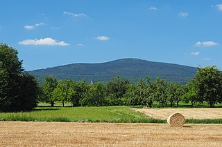
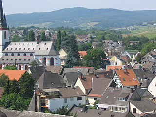
The Koberg is located in the eastern Hintertaunus. In the Taunus Nature Park, it rises directly south of Haintchen, a district of the municipality of Selters (Taunus). The Eisenbach stream flows around the hill to the east and north. Around 0.8 km to the south is the 461.8 m high Suterkopf.
The wooded Koberg is part of the Feldberg-Langhals-Pferdskopf-Scholle, which separates the Emsbachtal from the Weiltal. Together with the Suterkopf and the Blumenstück (445 m), it forms the last north-western mountains of this plateau.
The Koberg belongs to the Taunus main natural unit group (No. 30), in the main unit Östlicher Hintertaunus (302) to the Pferdskopf-Taunus natural area (302.6).

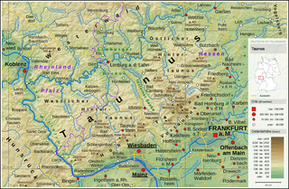
The Taunus is a mountain range in Hesse, Germany, located north west of Frankfurt and north of Wiesbaden. The tallest peak in the range is Großer Feldberg at 878 m; other notable peaks are Kleiner Feldberg and Altkönig.
Main-Taunus is a Kreis (district) in the middle of Hessen, Germany and is part of the Frankfurt/Rhine-Main Metropolitan Region as well as the Frankfurt urban area. Neighboring districts are Hochtaunuskreis, district-free Frankfurt, Groß-Gerau, district-free Wiesbaden, Rheingau-Taunus. It is the second most densely populated rural district in Germany.
Schmitten im Taunus is a municipality in the Hochtaunuskreis in Hessen, Germany.

Selters (Taunus) is a municipality with 8,000 inhabitants north of Bad Camberg in Limburg-Weilburg district in Hesse, Germany.

Aizkorri or Aitzgorri is a massif, the highest one of the Basque Autonomous Community (Spain) with 1,551 m AMSL at its highest point. The massif is formed by a crest of limestone summits aligned north-west to south-east all in a row at the south of the province of Gipuzkoa, namely Artzanburu, Andreaitz, Arbelaitz (1,513 m), Iraule (1,511 m), Aitxuri, Aketegi (1,549 m) and Aizkorri (1,528 m). Despite its slightly lower height, this summit is the most popular one. The Aizkorri massif is one of the most conspicuous geological formations on the Basque Mountains range.

Heidenrod is a municipality in the Rheingau-Taunus-Kreis in the Regierungsbezirk of Darmstadt in Hesse, Germany. Seat of municipal administration is to be found in the most populated municipal district, in Laufenselden.

This division of Germany into major natural regions takes account primarily of geomorphological, geological, hydrological, and pedological criteria in order to divide the country into large, physical units with a common geographical basis. Political boundaries play no part in this, apart from defining the national border.
The Gießen-Koblenz Lahn Valley is a bowl in western Hesse and eastern Rhineland-Palatinate in Germany that contains the lower course of the Lahn as well as the Limburg Basin. It falls within natural region no. 31 as defined by the BfN. It extends from Leun to the mouth of the Lahn into the river Rhine near Lahnstein. Despite its name it does not reach as far east as Gießen, but ends west of Wetzlar.

The Gladenbach Uplands, named after their central town of Gladenbach, is a range of hills up to 609 m high in the Rhine Massif in Germany, on the junction of the Rothaar Mountains, Westerwald (southwest), (Eastern) Hintertaunus and West Hesse Highlands in the east. It lies in Central Hesse within the districts of Marburg-Biedenkopf, Lahn-Dill and Gießen within the so-called Lahn-Dill-(Dietzhölze-) loop. Small parts of the Upper Lahn Valley in the northwest belong, together with the town of Bad Laasphe, also to the district of Siegen-Wittgenstein, North Rhine-Westphalia.
The Altkönig is the third highest mountain of the Taunus range in Hesse, Germany, reaching a height of 798.2 m above sea level (NHN).

The Steinkopf near Ober-Rosbach in the county of Wetteraukreis and Pfaffenwiesbach in the county of Hochtaunuskreis in the German state of Hesse is a hill, 518 m above sea level (NHN), in the eastern Taunus and the easternmost Taunus eminence over 300 m. It has an isolation of 10.170 km and a prominence of 173 m and is thus one of the five independent summits in the Taunus. The Steinkopf is a landmark visible from a long distance especially for the immediately adjacent region of Wetterau to the east.

The Nassau Nature Park is a 561.71 km² nature park in the southwestern Westerwald and northwestern Taunus in Rhineland-Palatinate. It was designated in November 1963 and expanded in 1979.
The High Taunus is the name of a major natural region unit in the Hessian Central Uplands range of the Taunus mountains and forms the area immediately around the main ridge of the Taunus. It should not be confused with the term Hochtaunus, in the sense used in the name of the county of Hochtaunuskreis which is only the eastern part of the Feldberg massif. The High Taunus separates the Anterior Taunus in the south from the Lower Taunus in the north and includes the majority of the highest mountains and hills of the Taunus. The eastern part of the natural region lies within the Taunus Nature Park and its western part in the Rhine-Taunus Nature Park.

The main ridge of the Taunus refers to a 75-kilometre-long ridgeline in the High Taunus mountain in Germany, whose geological core consists of veins of hard Taunus quartzite and which separates the steeply descending Anterior Taunus to the south from the more gradually descending upland of the Hintertaunus or Farther Taunus in the north. The watershed between the Upper Rhine and River Main to the south and the Middle Rhine tributaries of the Wisper and Lahn to the north, runs for long sections along the main ridge. Several of the river flowing southwards have broken through the rock of the Taunus ridge unit in several places so that the watershed is diverted a few kilometres to the north.
The Taunus Nature Park is a nature park in Central Germany with an area of 134,775 hectares (1347.75 km2) in the Central Upland range of the Taunus. It is one of two Hessian nature parks in the Taunus and the second largest nature park in Hesse.
The Hintertaunus is a natural region in the German Central Upland range of the Taunus, which rises to a height of 700.7 m above sea level (NHN) and lies north of the High Taunus (301). It extends as far as the river Rhine to the west, the river Lahn to the north and the Wetterau hills to the east. It is divided into the Eastern Hintertaunus, Idstein Basin (303) and Western Hintertaunus (304).
The Limburg Basin is one of the two large intramontane lowland areas within the Rhenish Massif in Germany, the other being the Middle Rhine Basin. It forms the central part of the natural region of the Gießen-Koblenz Lahn Valley between the Weilburg Lahn Valley Region and the Lower Lahn Valley on both sides of the Lahn around the town of Limburg.

The White Wall in the Taunus is a quartzite field on the Altkönig that was formed in the ice age as a result of frost weathering. It lies at a maximum elevation of 634 m above sea level (NHN) near Oberursel in the Hessian county of Hochtaunuskreis in Germany.
The Rheingau Mountains or Rheingau Hills form the westernmost section of the High Taunus and extend for 20 kilometres in a south-west to north-east direction between the Rhine valley near Lorch and Assmannshausen in the west and the Walluf valley near Schlangenbad in the east. The highest point is the 619-metre-high mountain of Kalte Herberge. The Rheinhöhenweg Trail on the right bank of the Rhine runs along the ridgeline of the mountains which are part of the main crest of the Taunus.
50°21′13″N8°19′00″E / 50.35361°N 8.31667°E
| | This Hesse location article is a stub. You can help Wikipedia by expanding it. |