Related Research Articles

Kisumu is the third-largest city in Kenya located in the Lake Victoria area in the former Nyanza Province. It is the second-largest city after Kampala in the Lake Victoria Basin. The city has a population of slightly over 600,000. The metro region, including Maseno and Ahero, has a population of 1,155,574 people according to the 2019 Kenya Population and Housing Census which was conducted by the Kenya National Bureau of Statistics.
Kakamega is a town in western Kenya lying about 30 km north of the Equator. It is the headquarters of Kakamega County that has a population of 1,867,579. The town has an urban population of 107,227.
Nyanza Province was one of Kenya's eight administrative provinces before the formation of the 47 counties under the 2010 constitution. Six counties were organised in the area of the former province.
Vihiga is a town in Kenya located on the eastern side of the Kakamega Forest.

Kisumu County is one of 47 counties in the Republic of Kenya. Its borders follow those of the original Kisumu District, one of the former administrative districts of the former Nyanza Province in western Kenya. Its headquarters is Kisumu City which is the third largest city in Kenya after the capital Nairobi and the coastal city of Mombasa. It has a population of 1,155,574. The land area of Kisumu County totals 2085.9 km2.

Kericho County is one of the 47 counties in Kenya. The county seats between longitude 35°02' and 35°40' East and between the equator and latitude 0°23' South with an altitude of about 2002m above sea level. It borders Uasin Gishu County to the North, Baringo County to the North-East, Nandi County to the North-West, Nakuru County to the East and Bomet County to the South, Kisumu County to the Northwest and Nyamira County to the West. It had a population of 901,777 and an area of 2,111 km². Its capital and largest town is Kericho.

Siaya County is one of the counties in the former Nyanza Province in western Kenya. It is bordered by Busia County to the north, Kakamega County, and Vihiga County to the northeast and Kisumu County to the southeast. It shares a water border with Homa Bay County which is located south of Siaya County. The total area of the county is approximately 2,496.1 km2. The county lies between latitude 0° 26' to 0° 18' north and longitude 33° 58' east and 34° 33' west. Siaya has been split up into six new districts (sub-counties). Under the 2010 Constitution, the role of the districts is still unclear as much of the administrative authority was transferred to the county. The capital is Siaya, town, although the largest town is Bondo.

Taita–Taveta County is a county in Kenya, located approximately 200 km northwest of Mombasa, and 360 km southeast of Nairobi, it has a port and major gateway to the United Republic of Tanzania through Taveta. The county headquarters are located in Mwatate. It is one of the six counties in the Coastal region of Kenya. Major towns include Voi, Taveta, Mwatate, and Wundanyi.

Local authorities in Kenya are the bodies controlling local governance in urban areas in Kenya.
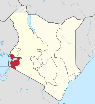
Homa Bay County is a county in the former Nyanza Province of Kenya. Its capital and largest town is Homa Bay. The county has a population of 1,131,950 and an area of 3,154.7 km2. Lake Victoria is a major source of livelihood for Homa Bay County. It has 40 wards, each represented by an MCA in the Homa Bay county assembly located in Homa Bay town, which is the county headquarters.
Londiani is a town in Kericho County, Kenya. It is 49 km from Kericho, which is about a 50-minute drive. As of 2009, it had a total population of 44,953.
Kisumu Rural Constituency was a former electoral constituency in Kenya. It was one of three constituencies of Kisumu District. The constituency was established for the 1963 elections. The constituency had eight wards, all of which elected councillors for Kisumu County Council.
Kisumu Town East is an electoral constituency in Kenya. It is one of seven constituencies of Kisumu County. The constituency was established for the 1997 elections, when the larger Kisumu Town Constituency was split into Kisumu Town West and East Constituencies. The constituency has six wards, all electing councillors for Kisumu municipality.
Kisumu Town West is an electoral constituency in Kenya. It is one of seven constituencies of Kisumu County. The constituency was established for the 1997 elections, when the larger Kisumu Town Constituency was split into Kisumu Town East and West Constituencies. The constituency has eleven wards, all electing councillors for Kisumu municipality.
Nyakach is an electoral constituency in Kenya. It is one of seven constituencies of Kisumu County. The constituency has five wards, all electing MCAs for the Kisumu County Assembly and has a population of 150,320 people based on the 2019 census report.
Nyando is an electoral constituency in Kenya. It is one of seven constituencies of Kisumu County.
Rabuor is a village belong to Kobura Ward, Kisumu County, Kenya.
Bunyore is a locality in the Vihiga County in the western province of Kenya. It is largely inhabited by Luhya, who speak the OLunyole dialect of the Luhya language. In the local language, the place is known as Ebunyore and its people as the Abanyore. It is divided into eight locations namely Central Bunyore, West Bunyore, South Bunyore, South-West Bunyore, East Bunyore, North Bunyore, North East Bunyore, and Wekhomo. Prior to 1990, Bunyore was under Kakamega District, divided into East and West Bunyore locations. As population increased, the former West Bunyore was split into Central, West, South and South West locations while the former East Bunyore was split into North, North East, Wekhomo and East Bunyore locations in order to better serve the people.
Local elections were held in Kenya on 4 March 2013 as part of the general elections. Voters elected governors and members of County Assemblies of the 47 counties created by the 2010 constitution.
Kondele is a district of the city of Kisumu, the third largest city in Kenya, and the second largest city, after Kampala, in the Lake Victoria Basin. Kondele is the most densely populated of the three satellite towns of Kisumu metropolitan region, the others being Maseno and Ahero. It is Kisumu City's most notable region and cultural identifier and one of the most densely populated regions in Kisumu County, Kenya. It lies on the A1 road that connects Kisumu and Vihiga. The town is administered by the Kondele County Assembly ward, an administrative ward which is part of the wards that represent Kisumu Central constituency in Kisumu county assembly. The ward is represented by the Kondele Member of County Assembly.
References
| | This Kenya location article is a stub. You can help Wikipedia by expanding it. |