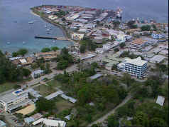
Victoria Island is a large island in the Canadian Arctic Archipelago that straddles the boundary between Nunavut and the Northwest Territories of Canada. It is the eighth largest island in the world, and at 217,291 km2 (83,897 sq mi) in area, it is Canada's second largest island. It is nearly double the size of Newfoundland (111,390 km2 [43,008 sq mi]), and is slightly larger than the island of Great Britain (209,331 km2 [80,823 sq mi]) but smaller than Honshu (225,800 km2 [87,182 sq mi]). It contains the world's largest island within an island within an island. The western third of the island belongs to the Inuvik Region in the Northwest Territories; the remainder is part of Nunavut's Kitikmeot Region.

The Pacific Time Zone (PT) is a time zone encompassing parts of western Canada, the western United States, and western Mexico. Places in this zone observe standard time by subtracting eight hours from Coordinated Universal Time (UTC−08:00). During daylight saving time, a time offset of UTC−07:00 is used.

U.S. Route 43 (US 43) is a 410-mile-long (660 km) north–south United States Highway in the East South Central States of Alabama and Tennessee. It travels from Prichard, Alabama to Columbia, Tennessee. The highway's southern terminus is in Prichard, at an intersection with US 90. Its northern terminus is in Columbia, Tennessee, at an intersection with US 31/US 412/US 412 Bus.

Murgash Glacier is the 3.4 km long and 3.2 km wide glacier on Greenwich Island in the South Shetland Islands, Antarctica situated southeast of Yakoruda Glacier, south of Teteven Glacier, southwest of Traub Glacier and west-northwest of Bravo Glacier. It is bounded by Lloyd Hill on the northwest, Tile Ridge on the east and Hebrizelm Hill on the southeast, and drains southwards into Kramolin Cove in McFarlane Strait between Yovkov Point and Kaspichan Point.
Wulfila Glacier is located on the southern slopes of Breznik Heights, Greenwich Island in the South Shetland Islands, Antarctica, south-southwest of Solis Glacier and west of Zheravna Glacier. It is bounded by Oborishte Ridge to the northwest, Nevlya Peak to the north, Terter Peak and Razgrad Peak to the northeast, and Ephraim Bluff to the southeast. The glacier extends 3 km in northwest-southeast direction and 2 km in northeast-southwest direction, draining southwestwards into McFarlane Strait between Ephraim Bluff and the base of Provadiya Hook.

Berkovitsa Glacier is a glacier on Livingston Island, Antarctica situated east of Etar Snowfield, south of Medven Glacier, west-northwest of Tundzha Glacier and north-northeast of Verila Glacier. It is bounded by the southeastern slopes of Oryahovo Heights and the northwestern slopes of Snow Peak. It extends 4km in southeast-northwest direction and 2.8km in northwest-southeast direction, and drains northeastwards into Hero Bay between Avitohol Point and Remetalk Point.
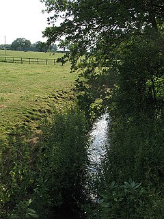
The River Croco is a small river in Cheshire in England. It starts as lowland field drainage west of Congleton, flows along the south edge of Holmes Chapel, and joins the River Dane at Middlewich. It is about 8 miles (13 km) long.
Galloway Road, also known as West 87th Avenue, is a north-south route through the western areas of suburban Miami-Dade County, Florida, from the Black Point area south of Cutler Bay almost to the Broward County line north of Miami Lakes. It exists in seven different unconnected segments that total 27.5 miles (44.3 km) in length, acting as connecting roads, neighborhood streets, and arterial routes. Approximately 9.5 miles (15.3 km) of Galloway Road, between Pinecrest and Doral, is designated as State Road 973.
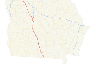
State Route 7 (SR 7) is a 216.0-mile-long (347.6 km) state highway that travels in a southeast-to-northwest orientation through portions of Lowndes, Cook, Tift, Turner, Crisp, Dooly, Houston, Peach, Crawford, Monroe, Lamar, Pike, and Spalding counties in the southern and central parts of the U.S. state of Georgia. The highway connects the Florida state line southeast of Lake Park to the Griffin area, via Valdosta, Tifton, Cordele, Perry, and Barnesville. The highway is concurrent with either US 41 or US 341 for its entire length, and closely parallels I-75 for much of its length.

State Route 17 (SR 17) is a 294-mile-long (473 km) state highway that travels south-to-north through portions of Chatham, Effingham, Screven, Jenkins, Burke, Jefferson, Warren, McDuffie, Wilkes, Elbert, Hart, Franklin, Stephens, Habersham, White, and Towns counties in the east-central and northeastern parts of the U.S. state of Georgia. The highway connects Interstate 16 (I-16) in Bloomingdale to the North Carolina state line, northwest of Hiawassee, via Millen, Louisville, Wrens, Thomson, Washington, Elberton, Royston, Toccoa, Clarkesville, and Hiawassee.
Highway 943 is a provincial highway in the northwest region of the Canadian province of Saskatchewan. It runs from the settlement of Meetoos, where it continues as Highway 698, to Highway 942 northwest of Big River. Highway 943 is about 69 km (43 mi) long.

Dalgopol Glacier is a 1.8 nautical miles long glacier draining the northwest slopes of Imeon Range on Smith Island in the South Shetland Islands, Antarctica. It is situated northeast of Vetrino Glacier and southwest of Kongur Glacier, and flows north of Mount Pisgah and northwest of Mezek Peak into Drake Passage. Bulgarian early mapping in 2009. The glacier is named after the town of Dalgopol in northeastern Bulgaria.
Vetrino Glacier is a 3.2 km long glacier on the northwest side of Imeon Range on Smith Island in the South Shetland Islands, Antarctica. It is situated northeast of Yablanitsa Glacier, southwest of Dalgopol Glacier and northwest of Ovech Glacier, drains the northwest slopes of Imeon Range north of Drinov Peak, northwest of Kostenets Saddle and west of Mount Pisgah, and flows northwestwards into Drake Passage both northeast and south of Gregory Point. The glacier is named after the town of Vetrino in northeastern Bulgaria.
Chuprene Glacier is a 2.1 nautical miles long glacier draining the northwest slopes of Imeon Range on Smith Island in the South Shetland Islands, Antarctica. It is situated northeast of Bistra Glacier, southwest of Yablanitsa Glacier and northwest of Krivodol Glacier, Pashuk Glacier and Rupite Glacier, and flows southwest of Drinov Peak and Popovo Saddle, and west of Slatina Peak and Varshets Saddle southwestward along the northwest slopes of Antim Peak and Evlogi Peak into Drake Passage south of Villagra Point and north of Garmen Point. Bulgarian early mapping in 2009. The glacier is named after the settlement of Chuprene in northwestern Bulgaria.

This is a list of the National Register of Historic Places listings in Northwest Philadelphia.

Ogoya Glacier is the 8 km long and 3 km wide glacier on Trinity Peninsula, Antarctic Peninsula. Situated west-northwest of Laclavère Plateau, northwest of Broad Valley and northeast of Sestrimo Glacier. Draining the northeast slopes of Morro del Paso Peak, the north side of Misty Pass and the northwest slopes of Dabnik Peak, and flowing northwards to enter Huon Bay in Bransfield Strait.

Kandla is a village in Saaremaa Parish, Saare County in western Estonia. It is located 21.4 kilometres (13.3 mi) by road northwest of Kuressaare, just to the northwest of Jõempa.

Ramorino Glacier is the 4.5 nautical miles long glacier situated northwest of upper Crosswell Glacier and southeast of Cervellati Glacier on the east slope of Sentinel Range in the Ellsworth Mountains, Antarctica. It flows northeastwards between Epperly Ridge and Shinn Ridge, and enters Crosswell Glacier northwest of Mount Segers. The feature was named by US-ACAN in 2006 after Maria Chiara Ramorino, manager of the Italian team that compiled and promulgated the SCAR Composite Gazetteer of Antarctica, 1998-2006.

The Mirrool Creek, a watercourse that is part of the Lachlan sub-catchment of the Murrumbidgee catchment within the Murray–Darling basin, is located in the Riverina region of New South Wales, Australia. The course of the Mirrool Creek is indefinite at various locations.