
The Herzegovina-Neretva Canton is one of 10 cantons of the Federation of Bosnia and Herzegovina in Bosnia and Herzegovina.
West Vračar or Zapadni Vračar, is a former urban neighborhood and municipality of Belgrade, the capital of Serbia. It was located in Belgrade's municipality of Savski Venac to which northern section it generally corresponds today.
In Bosnia and Herzegovina the smallest administrative unit is the municipality. Prior to the 1992–95 Bosnian War there were 109 municipalities in what was then Socialist Republic of Bosnia and Herzegovina. Ten of these formed the area of the capital Sarajevo.

Kareli is a district of Georgia, in the region of Shida Kartli. Some northern territories of the district are part of the self-proclaimed republic of South Ossetia and have not been under control of the Georgian government since 1992.

Hreša is a mountain village located near Sarajevo, capital of Bosnia and Herzegovina. Hreša is located in Istočni Stari Grad, municipality in City of East Sarajevo, Republika Srpska, Bosnia and Herzegovina. It was also known as Srpski Stari Grad, and was created from part of the pre-war municipality of Stari Grad. Hreša is the biggest place of Istočni Stari Grad.

Ciechomin is a village in the administrative district of Gmina Aleksandrów, within Piotrków County, Łódź Voivodeship, in central Poland. It lies approximately 4 kilometres (2 mi) east of Aleksandrów, 29 km (18 mi) south-east of Piotrków Trybunalski, and 69 km (43 mi) south-east of the regional capital Łódź.

Zijemlje is a village and the seat of Istočni Mostar municipality in Republika Srpska, Bosnia and Herzegovina.
Kamena is a village in Istočni Mostar municipality, Republika Srpska, Bosnia and Herzegovina.
Dąbrowa is a village in the administrative district of Gmina Koło, within Koło County, Greater Poland Voivodeship, in west-central Poland.
Gołubie-Wybudowanie is a village in the administrative district of Gmina Stężyca, within Kartuzy County, Pomeranian Voivodeship, in northern Poland. It lies approximately 6 kilometres (4 mi) east of Stężyca, 17 km (11 mi) south-west of Kartuzy, and 43 km (27 mi) west of the regional capital Gdańsk.
Mokko, Niger is a village and rural commune in Niger.
Tolkūnai (Varėna) is a village in Varėna district municipality, in Alytus County, in southeastern Lithuania. According to the 2001 census, the village has a population of 171 people.
Bulozi is a village in municipality of Istočni Stari Grad, Republika Srpska, Bosnia and Herzegovina.
Kumane is a village in municipality of Istočni Stari Grad, Republika Srpska, Bosnia and Herzegovina.
Jablanica (Maglaj) is a village in the municipality of Maglaj, Bosnia and Herzegovina.
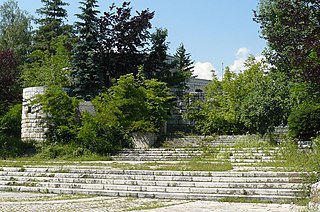
The Vraca Memorial Park is a park dedicated to the World War II victims in Sarajevo. It covers 78,000 square meters and mentions the names of over 11,000 men, women, and children killed during World War II.
Veselčani is a village in Municipality of Prilep.

Diocese of Duvno was a Latin Roman Catholic diocese in the area of present Bosnia and Herzegovina.

The ninth electoral unit of Republika Srpska is a parliamentary constituency used to elect members to the National Assembly of Republika Srpska since 2014. It consists of the Municipalities of Nevesinje, Kalinovik, Gacko, Foča, Novo Goražde, Čajniče, Rudo, Berkovići, Ljubinje, Bileća, Trebinje, Višegrad and Istočni Mostar.


