Russian(s) refers to anything related to Russia, including:
Walter Sisulu University (WSU) is a university of technology and science located in Mthatha, East London, Butterworth and Komani (Queenstown) in the Eastern Cape, South Africa, which came into existence on 1 July 2005 as a result of a merger between Border Technikon, Eastern Cape Technikon and the University of Transkei. The university is named after Walter Sisulu, a prominent figure in the struggle against apartheid.

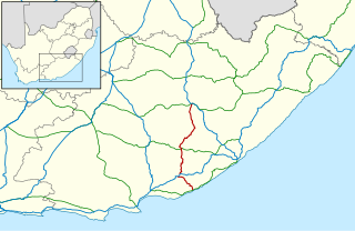
The R61 is a long provincial route in South Africa that connects Beaufort West with Port Shepstone via Graaff-Reinet, Komani, Mthatha and Port Edward.
The R67 is a provincial route in Eastern Cape, South Africa that connects Port Alfred with Komani via Grahamstown.
The R392 is a Regional Route in South Africa that connects Walaza with Komani via Sterkspruit, Lady Grey and Dordrecht.

Queenstown, is a town in the middle of the Eastern Cape Province of South Africa, roughly halfway between the smaller towns of Cathcart and Sterkstroom on the N6 National Route. The town was established in 1853 and is currently the commercial, administrative, and educational centre of the surrounding farming district.

The Chris Hani District Municipality is a landlocked district municipality situated in the centre of the Eastern Cape province of South Africa and is made up of eight local municipalities. Most of the communities are in rural areas. The landscape ranges from moist uplands and grassland hills to the arid Karoo scrubland.

Tarkastad is a Karoo semi-urban settlement situated on the banks of Tarka River in the Eastern Cape province of South Africa. Tarkastad is on a plain to the north of the Winterberg mountain range on the R61 between Cradock and Komani and only three hours from Gqeberha. The name Tarkastad is believed to come from the Khoi-Khoi word Traka or the Celtic word Tarka and the Afrikaans word Stad. The fact that the town is overlooked by Martha and Mary; two peaks which look like two women resting after a hard day's work, also lends to the name.

The N6 is a national route in South Africa that connects East London with Bloemfontein, via Komani and Maletswai. It runs roughly from north to south, connecting the N1 with the N2.
Ezibeleni is a township in the Eastern Cape Province of South Africa. It was established in the 1960s and officially recognised in 1974, when black South Africans were not allowed to live, but only to work, in the white-dominated Queenstown. In order to pursue the policy of separate development, the apartheid-era government of the time dictated that, due to its location on the map and the predominant Xhosa ethnicity of its people, Ezibeleni would belong to Transkei, one of ten fragmented batustans, or homelands, scattered across South Africa.
Bongolo Dam, is located on the Komani River, near Queenstown, Eastern Cape, South Africa. The dam has a capacity of 7,015,000 cubic metres (247,700,000 cu ft). The Bongolo Dam, about 5 kilometres (3.1 mi) from town on the Dordrecht road, is one of Queenstown's main sources of water, its main purpose is for industrial and municipal usage. The wall was begun in 1905 and was for years the largest concrete dam wall in South Africa. Incidentally the origin of the name Bongola has caused some controversy, but it is believed by some to have been derived from the Xhosa language word mbongolo meaning donkey, as these animals were extensively used in the construction of the dam.
The Komani River, is a river part of the Great Kei River system in the Eastern Cape, South Africa. It is a short river originating north of Queenstown and joining up with the Klaas Smits River, just south of the same town.
The Klaas Smits River is a river part of the Great Kei River system in the Eastern Cape, South Africa. It originates south of Molteno and flows through Sterkstroom, first southwards and then southeastwards before joining up with the Black Kei River. Presently the Klaas Smits River is part of the Mzimvubu to Keiskama Water Management Area.
Transvaal is a historical geographic term associated with land north of the Vaal River in South Africa. A number of states and administrative divisions have carried the name Transvaal.
Komani Psychiatric Hospital is a government funded psychiatric hospital and drug rehabilitation centre in Queenstown, Eastern Cape in South Africa.
The R410 is a Regional Route in South Africa that connects Komani with Khowa via Lady Frere and Cala.
This page is based on this
Wikipedia article Text is available under the
CC BY-SA 4.0 license; additional terms may apply.
Images, videos and audio are available under their respective licenses.
