
Henry Hudson was an English sea explorer and navigator during the early 17th century, best known for his explorations of present-day Canada and parts of the northeastern United States.

The Arctic Archipelago, also known as the Canadian Arctic Archipelago, is a group of islands north of the Canadian mainland.

Nordaustlandet is the second-largest island in the archipelago of Svalbard, Norway, with an area of 14,443 square kilometres (5,576 sq mi). It lies north east of Spitsbergen, separated by Hinlopen Strait. Much of Nordaustlandet lies under large ice caps, mainly Austfonna and Vestfonna, the remaining parts of the north being tundra inhabited by reindeer and walruses. The island is uninhabited and lies entirely within Nordaust-Svalbard Nature Reserve.
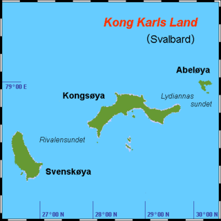
Kong Karls Land or King Charles Land is an island group in the Svalbard archipelago, in the Arctic Ocean. The island group covers an area of 342 km2 (132 sq mi) and is made up of the islands of Kongsøya, Svenskøya, Abel Island, Helgoland Island, and Tirpitzøya.
Lågøya is an island in Svalbard, Norway. It is situated north west of Nordaustlandet. The area is 103.5 km². The island has rarely been visited.

Bellsund is a 20-kilometer (12 mi) long sound on the west coast of Spitsbergen, part of the Svalbard archipelago of Norway. It is separated from Van Mijenfjorden by the islands of Akseløya and Mariaholmen. Bellsund is located south of Nordenskiöld Land and north of Wedel Jarlsberg Land.

Thousand Islands is a group of small islands south of Edgeøya. They form part of the Svalbard archipelago. The group consists of over forty islands and islets, including Brotskjer, Kulstadholmane, Utsira, Tufsen, Kong Ludvigøyane, Bölscheøya, Hornøya, Tiholmane, Meinickeøyane, Sletteøya, Schareholmane, Skråholmen, Brækmoholmane, Tareloppa, Vindholmen, and Menkeøyane.
Halvmåneøya is a small, uninhabited Norwegian island off the southeastern coast of Edgeøya, part of the Svalbard archipelago. Halvmåneøya, as part of Edgeøya, has been a nature preserve since 1973, and visitation is strictly regulated.

Heleysundet is a narrow sound between Kükenthaløya and Spitsbergen. It is known for its violent tidal races.
Tjuvfjorden is a 45 km long and up to 30 km wide fjord separating Edgeøya’s two southern promontories, Kvalpynten and Negerpynten.
Menkeøyane is a small Norwegian island group south of Halvmåneøya, an island off the southeast coast of Edgeøya. The group includes Havella, Alka, Gassen, Teisten, Islomen and Blåmåken. They comprise part of Thousand Islands. The islands are named after the German cartographer and historical geographer Heinrich Theodor Menke (1819–92). The islands appear on the Muscovy Company's map (1625), one of which is labeled Heling I.
Bölscheøya is an island southwest of Negerpynten, the southeastern point of Edgeøya. It is part of Thousand Islands. The island was named in 1868 by the German geographer August Petermann (1822–78) after the German journalist Carl Bölsche, father of the German writer and zoologist Wilhelm Bölsche (1843–93). The remains of a whaling station from the 17th century can be found on the island.
Meinickeøyane is an island group composed of two islets, Store Meinickeøya and Vesle Meinickeøya, that form part of Thousand Islands, an island group south of Edgeøya, part of the Svalbard archipelago. They were named after the German geographer Carl Eduard Meinicke (1803–76).
Lurøya is the largest island in Tiholmane, part of Thousand Islands, an island group south of Edgeøya.
Berentine Island is the southernmost island in Kong Ludvigøyane, part of Thousand Islands, an island group south of Edgeøya in Svalbard, Norway.
Bruhnsøya is a small island in Kong Ludvigøyane, an island group in Thousand Islands, an archipelago south of Edgeøya. The island is named after the German astronomer Carl Christian Bruhns (1830–81).
Russeholmane are the three outermost islets in Kong Ludvigøyane, part of Thousand Islands, an archipelago south of Edgeøya. Together with Ækongen they form Russebuholmane. They are named after a Russian trapper’s hut found on one of the islets.
Russeholmen is one of three islets that form part of Russeholmane, the westernmost group in Kong Ludvigøyane, part of Thousand Islands, an archipelago south of Edgeøya.


